
Today: Partly sunny, with a high near 36. Wind chill values as low as -5. Breezy, with a south wind 7 to 12 mph increasing to 13 to 18 mph in the afternoon. Winds could gust as high as 29 mph.
Tonight: Mostly cloudy, with a low around 18. West southwest wind 3 to 7 mph.
Tomorrow: Mostly sunny, with a high near 35. Breezy, with a northwest wind 5 to 10 mph increasing to 11 to 16 mph in the afternoon. Winds could gust as high as 24 mph.
Tom. Night: Mostly cloudy, with a low around 11. Northwest wind 5 to 10 mph becoming light west northwest after midnight.
Sunday: Mostly sunny, with a high near 33.
Monday: Sunny & breezy, with a high near 45.
Tuesday: Sunny, with a high near 45.
Thursday’s High in Atlantic was 21. Our Low this morning was -5 degrees. Last year on this date (Jan. 24th), the High in Atlantic was 37 and the Low was 33. The Record High was 66 in 1981, and the Record Low was -24 in 1894. Sunrise: 7:39. Sunset: 5:25.
Today: Mostly sunny & breezy. A high near 18. N/NW winds @ 5-15 mph w/gusts to near 20. Wind chill values as low as -10.
Tonight: Mostly clear. A low around 4. Winds S @ 5-10. Wind chill values as low as -5.
Tomorrow: Partly sunny & breezy. A high near 35. S winds 10-20 mph w/gusts to near 30.
Tom. Night: Mostly cloudy, with a low around 19. West northwest wind 5 to 10 mph.
Saturday: Partly sunny, with a high near 35.
Sunday: Mostly sunny, with a high near 32.
Monday: Sunny & breezy, with a high near 44.
Wednesday’s High in Atlantic was 36. Our Low this morning was 3 degrees. Last year on this date (Jan. 23rd), the High in Atlantic was 36 and the Low was 32. The Record High was 60 in 1981, and the Record Low was -24 in 1948. Sunrise: 7:40. Sunset: 5:24.
Today: Scattered flurries this morning, then a chance of snow. Cloudy, with a high near 33. S/SW winds 10-20 mph this morning becoming NW this afternoon. Wind chill values as low as zero. . New snow accumulation of less than a half inch possible.
Tonight: A slight chance of snow. Gradually becoming partly cloudy, with a low around 5. N/NW winds 10-20 mph. Wind chill values as low as -10.
Thursday: Mostly sunny, with a high near 18. N/NW winds 10-20 mph. Wind chill values as low as -10.
Thursday Night: Mostly clear, with a low around 2.
Friday: Partly sunny, with a high near 33. Breezy.
Friday Night: Mostly cloudy, with a low around 18.
Saturday: Partly sunny, with a high near 34.
Sunday: Partly sunny, with a high near 31.
Tuesday’s High (the 24-hour High) in Atlantic was 21 (that occurred at 4:30-a.m. today). The 24-hour Low was -13. Last year on this date (Jan. 22nd), the High in Atlantic was 33 and the Low was 27. The Record High was 60 in 1967, and the Record Low was -27 in 1930. Sunrise: 7:40. Sunset: 5:23.
Today: **EXTREME COLD WARNING IN EFFECT UNTIL NOON for dangerously cold wind chills as low as -35** Increasing clouds, with a high near 15. S/SW winds 10-15 mph this morning w/gusts to 30 mph this afternoon. Wind chill values as low as -25 to -35.
Tonight: Mostly cloudy, with a temperature rising to around 17 by 4am. S/SW winds 15-30 mph. Wind chill values as low as -10.
Wednesday: A 50% chance of snow. High near 32. SW winds 10-20 mph. Wind chill values as low as 5. New snow accumulation of less than a half inch possible.
Wednesday Night: Mostly cloudy, with a low around 9.
Thursday: Mostly sunny, with a high near 20.
Friday: Partly sunny, with a high near 29.
Saturday: Mostly cloudy, with a high near 33.
Monday’s High in Atlantic was 7. Our Low this morning was -16 (also the 24-hour Low). Last year on this date (Jan. 21st), the High in Atlantic was 27 and the Low was 6. The Record High was 58 in 1933, and the Record Low was -32 in 1976. Sunrise: 7:41. Sunset: 5:21.
TODAY (M.L.King Day): Partly-to-mostly cloudy w/a chance of flurries after noon. A high near 7. NW winds 15-25 mph this afternoon. Wind chill values as low as -20.
Tonight: A chance of flurries this evening, otherwise partly cloudy. Low around -13. NW winds 5-15 mph w/gusts to near 25. Wind chill values as low as -25. COLD WEATHER ADVISORY for very cold wind chills of -20 to -30 degrees are expected. The Advisory is in effect from 6-p.m. tonight until 9-a.m. Tuesday. Exposed skin can result in frostbite in as little as 30 minutes. Wear appropriate clothing (hat & gloves).
Tomorrow: Sunny, with a high near 13. W/SW winds 10-25 mph. Wind chill values as low as -25. COLD WEATHER ADVISORY in effect until 9-a.m.
Tom. Night: Mostly cloudy, with the temperature rising into the upper teens. S winds 10-25 mph.
Wednesday: Mostly cloudy w/a 30% chance of snow. High near 33. Wed. Night: Mostly Cloudy. Low 15.
Thursday: A 20% chance of snow after noon. Mostly cloudy. High near 26. Thu. Night: A 20% chance of snow. Low 8.
Friday: Partly sunny, with a high near 34.
Sunday’s High in Atlantic was 8. Our Low this morning was -7 (also the 24-hour Low). Last year on this date (Jan. 20th), the High in Atlantic was 6 and the Low was -20. The Record High was 64 in 1895, and the Record Low was -26 in 1962. Sunrise: 7:41. Sunset: 5:20.
Today: **COLD WEATHER ADVISORY UNTIL NOON**Sunny and cold, with a high near 7. NW winds 10-25 mph. Wind chill values as low as -25.
Sunday Night: Mostly clear, with a low around -5. Winds West at 5-10 mph. Wind chill values as low as -15.
M.L.King Day (Monday): **COLD WEATHER ADVISORY from 3-a.m. until Noon** Mostly sunny and cold, with a high near 8. W/NW winds 10-25 mph. Wind chill values as low as -20.
Monday Night: Mostly clear, with a low around -11. NW winds 10-20 mph.
Tuesday: Sunny, with a high near 15.
Tuesday Night: Mostly cloudy, with a low around 7.
Wednesday: Mostly cloudy, with a high near 34.
Wednesday Night: Mostly cloudy, with a low around 16.
Thursday: Partly sunny, with a high near 27.
Saturday’s High in Atlantic was 21. Our Low this morning was -7 (also the 24-hour Low). Last year on this date (Jan. 19th), the High in Atlantic was 4 and the Low was -18. The Record High was 56 in 1895, and the Record Low was -38 in 1892. Sunrise: 7:42. Sunset: 5:19.
Today: Mostly sunny, with a high near 18. Winds N @ 15-30 mph. Wind chill values as low as -10.
Tonight: Mostly cloudy. Low around -4. N/NW winds 10-25 mph. Wind chill values as low as -20.
Tomorrow: **Cold Weather Advisory in effect from 3-a.m. until Noon, for wind chill values of -20 to -35 degrees** Sunny and cold. High near 7. NW winds 10-25 mph.
Tom. Night: Mostly clear, with a low around -6.
M.L.King Day (Monday): Sunny and cold, with a high near 9.
Monday Night: Mostly clear, with a low around -9.
Tuesday: Sunny, with a high near 15.
Wednesday: Partly sunny, with a high near 34.
Friday’s High in Atlantic was 48. Our Low this morning (as of 7-a.m., & the 24-hour Low) was 9. Last year on this date (Jan. 18th), the High in Atlantic was 22 and the Low was -5. The Record High was 61 in 1951, and the Record Low was -28 in 1984. Sunrise: 7:43. Sunset: 5:18.
Today: Partly cloudy to cloudy & breezy, w/a chance of sprinkles late this afternoon. High near 47. Winds S/SW at 10-15 this morning becoming N/NW this afternoon w/gusts as high as 25 mph.
Tonight: Cloudy w/a chance of sprinkles or flurries this evening, then a chance of flurries. Gradually becoming partly cloudy, with a low around 7. N/NW winds 15-35 mph w/gusts to around 45 mph possible. Wind chill values as low as -5.
Tomorrow: Mostly sunny, cold & blustery. High near 17. N/NW winds 15-30 mph. Wind chill values as low as -15.
Tom. Night: Mostly cloudy, with a low around -4. N/NW @ 10-20 mph.
Sunday: Sunny, cold, & blustery with a high near 7. Bitterly cold wind chills of 15 below zero to 30 below zero are expected overnight and early mornings from Sunday through Tuesday morning.
Sunday Night: Mostly clear, with a low around -6.
M.L.King Day: Mostly sunny, cold & continued blustery, with a high near 8.
Monday Night: Mostly clear, with a low around -9.
Tuesday: Sunny, with a high near 14.
Thursday’s High in Atlantic was 46. The Low was 27. Last year on this date (Jan. 17th), the High in Atlantic was 21 and the Low was 4. The Record High was 57 in 1989, and the Record Low was -21 in 1984. Sunrise: 7:43. Sunset: 5:17.
Today: Sunny. A high near 41. NW winds 5-10 mph becoming southwest this afternoon w/gusts to around 20 mph.
Tonight: Partly cloudy. Low around 26. SW-S @ 10-25 mph.
Tomorrow: Increasingly cloudy. High near 43. S/Sw @ 10-20 becoming N/NW & gusting to near 25 mph.
Tom. Night: Mostly cloudy & windy, with a low around 9. NW @ 15-35 mph.
Saturday: Mostly sunny & windy, with a high near 18.
Sunday: Sunny, cold & blustery, with a high near 7.
M.L.King Day: Mostly sunny and cold, with a high near 7.
Wednesday’s High in Atlantic was 34. The Low was 8. Last year on this date (Jan. 16th), the High in Atlantic was 5 and the Low was -9. The Record High was 64 in 1990, and the Record Low was -25 in 2009. Sunrise: 7:44. Sunset: 5:16.
(Radio Iowa) – More bitter cold weather is predicted by this weekend, with high temperatures in single digits, and while the freezing forecast is hard on all of us, it’s particularly tough for Iowa’s oldest residents. Stephanie Humphries owns “Right at Home” operations in Cedar Rapids and Waterloo, offering in-home care to seniors and adults with disabilities who want to live independently. She says gauging an older person’s capabilities may involve nudging them to make a shift in thinking. “Do they have someone arranged to clear their sidewalks or driveways?” Humphries says. “Some of our older adults maybe still try to do those things themselves, but they really need to evaluate what their mobility is like and what their balance is like.”
Even if there hasn’t been snow, sidewalks can be slippery. If they’re venturing out, Humphries says seniors need to have good footwear for the weather, like shoes or boots with a solid rubber sole. “A lot of our older adults use walking devices to help them keep their balance,” she says. “There are attachments that you can get, just nice little gadgets that you can put on the bottoms of canes and walkers to help them navigate through the snowy and icy weather.” Older homes may need a little T-L-C in order to become more energy efficient during the frigid winters, and that costs money. Humphries says many Iowa communities have help available for seniors, someone who can come in and do minor jobs, often for free. 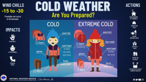
“There’s Aging Services through UnityPoint,” she says. “They’ve got a lot of different volunteers that can come in and help in the home, and then also can contract with individuals that, let’s say they’re retired contractors, or handy men, handy women, that can come in and do some renovations to the home.” When the weather’s especially wicked, it’s a good idea to check in on our elderly friends and loved ones, by phone, text, email or just dropping by. Still, how often should you do that to show you care, without being annoying? “It’s going to depend on your loved one, and what they’re contending with from a medical standpoint,” Humphries says, “but anywhere from one to three times a week, probably depending on, again, what their loved one’s living situation is like, and maybe their age, and abilities.”
She says it’s also a good idea to make sure they’re stocked up on all needed prescription medications and on non-perishable food items, just in case the weather turns really bad and you can’t stop by in person.


