
You can thank reserves built up at the end of last year for keeping Iowa in good shape water wise following a dry June. The areas impacted by drought have increased in the most recent report, but Tim Hall with the Iowa Department of Natural Resources says it could be a lot worse. “If you ignored the fall of 2015, we would be in a bit of jam right now. It’s been somewhat dry — especially in parts of the state — but I think we’re still benefiting from the really wet November and December we had, given the rainfall that’s fallen in this first half of the year,” Hall says.
The Iowa average streamflow index dropped below the normal line on July 4th. Hall says the level is tracked on a daily basis and it has been above normal since May of 2015. “That speaks more to how wet it has been recently than how dry it is now,” Hall says. “So that index has just now gotten down to the normal line…so it mostly tells us how wet it has been for quite awhile.” Parts of the state have moved into moderate drought conditions, but Hall is not worried.
“We’re a long ways away from being overly concerned,” he says. The moderate drought level is the first level, and Hall says it could easily turn around. “It’s a pretty short-term deal, because if you look a the long-term climate prediction information — there’s not long term drought predicted for that part of the state out through the end of September,” Hall explains. “So, even the climate folks are looking at this as a short-term impact.” Areas of the state have struggled with low water levels in the last few years appear to be doing okay now.
“Part of the state where we’ve been consistently concerned has been in the northwest corner of the state. And they have actually done pretty well precipitation wise this year,” Hall says. “So, if there was any part of the state where we would want to be particularly concerned it would be up there. But they’ve been running in the first half of the year much about normal for rainfall. So, they are in pretty good shape.” Hall says swings in weather pattern can always make a difference in the water situation.
“You’re always on that sort of razor’s edge between too wet and too dry. For quite awhile in the state we’ve been really running right down the middle where we want to be. And really, that’s where we are right now,” according to Hall. You can find out more about Iowa’s water trends at: www.iowadnr.gov/watersummaryupdate.
(Radio Iowa)
Today: areas of fog this morning; P/Cldy. High 85. NW @ 10-15.
Tonight: P/Cldy. Low 58.
Tomorrow: P/Cldy. High 84. E @ 5-10.
Sunday: P/Cldy. High 87.
Monday: P/Cldy w/isolated thundershowers. High near 90.
Thursday’s High in Atlantic was 83. Our 24-hour Low thru 7-a.m. today was 59. We received .15 of an inch of rain (15 one-hundredths) Thursday evening at the KJAN studios. Last year on this date, our High in Atlantic was 77 and the low was 51. The All-time Record High in Atlantic on this date was 102 in 1937. The Record Low was 42 in 1908.
352 AM CDT FRI JUL 8 2016
EARLY THIS MORNING…PARTLY CLOUDY. NORTHWEST WIND NEAR 5 MPH.
TODAY…SUNNY. HIGH IN THE MID 80S. NORTHWEST WIND 5 TO 10 MPH.
TONIGHT…PARTLY CLOUDY. LOW IN THE MID 60S. NORTHWEST WIND NEAR 5 MPH SHIFTING TO THE NORTHEAST AFTER MIDNIGHT.
SATURDAY…MOSTLY SUNNY. HIGH IN THE MID 80S. SOUTHEAST WIND 5 TO 10 MPH.
SUNDAY…MOSTLY SUNNY. HIGH IN THE UPPER 80S. SOUTH WIND 5 TO 15 MPH.
MONDAY…PARTLY SUNNY WITH A 20 PERCENT CHANCE OF THUNDERSTORMS. BREEZY. HIGH IN THE UPPER 80S.
SHELBY IA-HARRISON IA-POTTAWATTAMIE IA-
627 PM CDT THU JUL 7 2016
…SIGNIFICANT WEATHER ADVISORY FOR SOUTHERN SHELBY…SOUTHEASTERN HARRISON AND NORTHEASTERN POTTAWATTAMIE COUNTIES UNTIL 700 PM CDT…AT 627 PM CDT…DOPPLER RADAR WAS TRACKING A STRONG THUNDERSTORM NEAR PERSIA…OR 29 MILES WEST OF ATLANTIC…MOVING EAST AT 35 MPH. DIME SIZE HAIL AND WINDS IN EXCESS OF 30 MPH WILL BE POSSIBLE WITH THIS STORM.
LOCATIONS IMPACTED INCLUDE… AVOCA…WALNUT…SHELBY…MINDEN…PERSIA…TENNANT… PRAIRIE ROSE STATE PARK AND NISHNA BEND RECREATION AREA.
THIS INCLUDES THE FOLLOWING HIGHWAYS…
HIGHWAY 59 IN IOWA BETWEEN MILE MARKERS 61 AND 73.
INTERSTATE 80 IN IOWA BETWEEN MILE MARKERS 27 AND 48.
A SEVERE THUNDERSTORM WATCH REMAINS IN EFFECT UNTIL 1100 PM CDT FOR SOUTHWESTERN IOWA.
SHELBY IA-
629 PM CDT THU JUL 7 2016
…THE SEVERE THUNDERSTORM WARNING FOR NORTHEASTERN SHELBY COUNTY IS CANCELLED… THE STORM WHICH PROMPTED THE WARNING HAS WEAKENED BELOW SEVERE LIMITS…AND NO LONGER POSE AN IMMEDIATE THREAT TO LIFE OR PROPERTY. THEREFORE…THE WARNING HAS BEEN CANCELLED. HOWEVER SMALL HAIL…GUSTY WINDS AND HEAVY RAIN ARE STILL POSSIBLE WITH THIS THUNDERSTORM AS IT CONTINUES TO MOVE THROUGH NORTHEASTERN SHELBY COUNTY.
A SEVERE THUNDERSTORM WATCH REMAINS IN EFFECT UNTIL 1100 PM CDT FOR SOUTHWESTERN IOWA.
600 PM CDT THU JUL 7 2016
THE NATIONAL WEATHER SERVICE IN OMAHA HAS ISSUED A
* SEVERE THUNDERSTORM WARNING FOR…
NORTHERN SHELBY COUNTY IN SOUTHWESTERN IOWA…
* UNTIL 645 PM CDT
* AT 559 PM CDT…A SEVERE THUNDERSTORM WAS LOCATED WEST OF EARLING…OR 18 MILES SOUTH OF DENISON…MOVING EAST AT 35 MPH.
HAZARD…60 MPH WIND GUSTS AND QUARTER SIZE HAIL.
SOURCE…RADAR INDICATED.
IMPACT…HAIL DAMAGE TO VEHICLES IS EXPECTED. EXPECT WIND DAMAGE TO ROOFS…SIDING AND TREES.
* LOCATIONS IMPACTED INCLUDE…
HARLAN…EARLING…IRWIN…DEFIANCE…PANAMA…WESTPHALIA…
KIRKMAN AND MANTENO RECREATION AREA.
THIS INCLUDES HIGHWAY 59 IN IOWA BETWEEN MILE MARKERS 80 AND 89.
PRECAUTIONARY/PREPAREDNESS ACTIONS…
FOR YOUR PROTECTION MOVE TO AN INTERIOR ROOM ON THE LOWEST FLOOR OF A BUILDING.
SEVERE THUNDERSTORM WATCH OUTLINE UPDATE FOR WS 351
NWS STORM PREDICTION CENTER NORMAN OK
355 PM CDT THU JUL 7 2016

SEVERE THUNDERSTORM WATCH 351 IS IN EFFECT UNTIL 1100 PM CDT
FOR THE FOLLOWING LOCATIONS

IAC001-003-009-015-021-025-027-029-035-041-047-049-059-063-073-
077-079-081-085-091-093-109-119-121-129-133-137-141-143-147-149-
151-155-161-165-167-175-187-189-193-197-080400-
/O.NEW.KWNS.SV.A.0351.160707T2055Z-160708T0400Z/

IA
.    IOWA COUNTIES INCLUDED ARE

ADAIR                ADAMS               AUDUBON
BOONE                BUENA VISTA         CALHOUN
CARROLL              CASS                CHEROKEE
CLAY                 CRAWFORD            DALLAS
DICKINSON            EMMET               GREENE
GUTHRIE              HAMILTON            HANCOCK
HARRISON             HUMBOLDT            IDA
KOSSUTH              LYON                MADISON
MILLS                MONONA              MONTGOMERY
O`BRIEN              OSCEOLA             PALO ALTO
PLYMOUTH             POCAHONTAS          POTTAWATTAMIE
SAC                  SHELBY              SIOUX
UNION                WEBSTER             WINNEBAGO
WOODBURY             WRIGHT
Widespread damage to homes, businesses and crops was reported across western and northern Iowa after overnight thunderstorms brought heavy rain and strong winds approaching 70 miles an hour. Montgomery County emergency management coordinator Brian Hamman says severe storms rolled through Villisca at around 2 A-M. “I was out and followed the storms and entered the city of Villisca and found numerous tree limbs down,” Hamman says. “About the same time, the Villisca Fire Department was paged out to Forsman Farms, the chicken farm just southwest of town, for significant damage.”
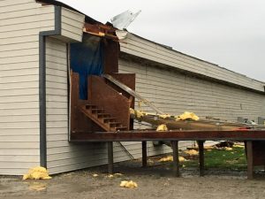
Forsman Farms damage (Brian Hamman – Montgomery EMA photos)
He says the damage at that facility is incredible. “The chicken plant at Forsman Farms sustained significant damage to pretty much every building, from minor roof damage to significant damage,” Hamman says. “The walkway has been blown off completely between two buildings and multiple garage doors were ripped out.”
In addition, Hamman says Villisca’s Municipal Power Plant sustained significant roof damage. “They’ve had the majority of their roof blown off,” he says. “They have a pitched roof on top of a flat roof and the majority of that pitch is off.”
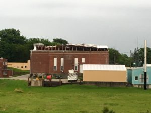
Villisca Power Plant
Downed trees and tree limbs dot the community and cleanup operations were underway Thursday morning. “The city of Villisca is taking care of all the tree branches that are down in the roadways and Forsman Farms has already contracted with a contractor to come out and make the repairs that are needed,” Hamman says. “Thankfully, it doesn’t sound like any of their chickens were affected and they still have electricity and are business as usual.”
(Radio Iowa)


