
Early this morning: Snow likely. Cloudy, with a steady temperature around 26. Total nighttime snow accumulation of less than a half inch possible.
Today: **WINTER WEATHER ADVISORY for mixed precipitation [Snow/freezing drizzle] continues until 6-p.m.**Snow likely, mainly before 2pm. Patchy blowing snow between 1pm and 3pm. Cloudy, with a temperature rising to near 26 by 11am, then falling to around 22 during the remainder of the day. N winds @ 10-20 mph w/gusts to near 30. Wind chill values as low as 10. New snow accumulation of less than one inch is expected.
Tonight: A slight chance of snow between midnight and 3am, then a chance of flurries. Mostly cloudy, with a low around 1. NW winds @ 15-30 mph. Wind chill values as low as -15.
Sunday: Partly sunny and cold, with a high near 10. NW winds 10-25 mph. Wind chill values as low as -20.
Sunday Night: Mostly cloudy, with a low around -6.
Washington’s Birthday: Snow likely, mainly before noon. Cloudy and cold, with a high near 8.
Monday Night: A 30% chance of snow, mainly before midnight. Cloudy, with a low around -13.
Tuesday: A 20% chance of snow. Mostly cloudy and cold, with a high near 0.
Friday’s High in Atlantic was 32. The Low was 16. We received .2″ (two-tenths of an inch) of snow Friday through early today, which melted into just .02″ (two one-hundredths) of an inch of liquid value. Last year on this date (Feb. 15th), the High in Atlantic was 41 and the Low was 19. The Record High was 72 in 1921, and the Record Low was -31 in 1905. Sunrise: 7:15. Sunset: 5:53.
(Radio Iowa) – Sitting in front of a roaring fire in the fireplace with your sweetheart might be the best option on this Valentine’s Day. National Weather Service Meteorologist Craig Cogil says another snowstorm will hit the state today (Friday). “We’re going to see winds increase quite quickly from the south by late morning into the afternoon, and that is likely to produce blowing snow, especially out in rural areas,” Cogil says. “With the winds from the south, it’s really going to impact those east-west roads with those snow crawlers going across the road, or maybe even some small drifts.” He says the winds and blowing snow are just part of the problem.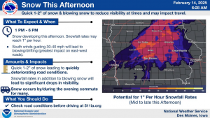
“It’s going to make travel a little hazardous all by itself. But then we’re also going to look at a brief period of moderate to possibly even heavy snow that moves quickly from southwest to northeast across Central Iowa during the afternoon hours,” he says. Cogil says we could see one to two inches of new snow which could also impact travel briefly during that time. The only good news from the storm is temperatures should lift out of the single digits. “With the south winds, we are going to see temperatures warm tomorrow. They should get up into the mid to upper 20s, maybe even some lower 30s down in southern Iowa, nothing real balmy, but certainly a little more normal than what we’re seeing now,” Cogil says. He says we could see another system move into the state Saturday with more snowfall. “Maybe two, three inches with that across the central part of the state. And then once that exits off on Saturday evening, we’re going to see a much colder air move into the state and likely remain for much of next week,” he says. Cogil says the snow contributes to the cold temperatures. 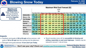
“With snow on the ground, especially, you know, during the night time, if your skies are clear and the winds are relatively light it really allows the heat to escape out, and so we really cool off colder than what you would normally get if you didn’t have that snow on the ground,” he says. “You know, it’s been the fortunate thing this winter is we haven’t seen a lot of snow on the ground, so it’s kept our temperatures relatively warm.” Cogil says it was inevitable that winter would push out the warmer weather. “It waited two and a half, or almost two and a half months to get here, but it’s here, and it’s going to let us know about it for the next week at least,” Cogil says.
Cogil says the next round of snow will likely be a little bit heavier than the light stuff we got earlier in the week. And he says we could even see it mixing in with a little bit of sleet or ice pellets.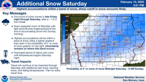
Today: Cloudy & windy w/a 60% chance of snow & patchy blowing snow. A high near 32. S winds 15-20 mph this morning, w/gusts to near 45 mph this afternoon. Wind chill values as low as -5. New snow accumulation of less than a half inch possible.
Tonight: A chance of freezing rain through midnight, then snow, possibly mixed with freezing rain. A low around 22. S/Se winds 10-20. Little or no ice accumulation expected. New snow accumulation of less than a half inch possible.
Tomorrow: A chance of snow and freezing rain in the morning, then snow & patchy blowing snow. High around 27 early with temps falling into the low 20’s during the day. N winds @ 10-20 w/gusts to near 30 mph. Wind chill values as low as 10. Little or no ice accumulation expected. New snow accumulation of 1 to 3 inches possible.
Tom. Night: Blustery, w/a slight chance of snow. Low around 0.
Sunday: Mostly sunny, cold & blustery, with a high near 9.
Washington’s Birthday: Snow likely, mainly before noon. A high near 4.
Tuesday: Mostly cloudy and cold, with a high near 1.
Thursday’s High in Atlantic was 16 (that was a 24-hour high, which occurred this morning). Our Low was -10. Last year on this date (Feb. 14th), the High in Atlantic was 59 and the Low was 20. The Record High was 68 in 1934, and the Record Low was -20 in 1936. Sunrise: 7:17. Sunset: 5:52.
Today: Sunny, with a high near 16. W/NW winds @ 5-10 this morning becoming S/SW this afternoon.Wind chill values as low as -20.
Tonight: Increasing clouds, with a low around 3. S winds 10-20. Wind chill values as low as -10.
Friday: Snow, mainly between 11am and 3pm. The snow could be heavy at times. Patchy blowing snow. A high near 30. S winds 15-35 mph. Wind chill values as low as -5. New snow accumulation of 1 to 2 inches possible.
Fri. Night: Snow likely after midnight. Low around 18. Winds S @ 5-15 mph w/gusts to near 25. New snow accumulation of less than a half inch possible.
Saturday: Snow likely, mainly before noon. Patchy blowing snow. A high near 29.
Sat.y Night: A 20% chance of snow after midnight.Blustery. A low around -5.
Sunday: Mostly sunny and cold, with a high near 7.
Sunday Night: Partly cloudy, with a low around -12.
Washington’s Birthday: Snow likely, mainly before noon. A high near 9.
Wednesday’s High in Atlantic was 12. Our Low this morning was -9. We received 1.2 inches of snow yesterday (for a total of 3 inches). The snow Wednesday melted into .15″ liquid precipitation. Last year on this date (Feb. 13th), the High in Atlantic was 54 and the Low was 20. The Record High was 63 in 1934, and the Record Low was -30 in 1905. Sunrise: 7:18. Sunset: 5:51.
(Radio Iowa) – While snow was finally falling across the state late Tuesday evening into Wednesday, it won’t make up for what State Climatologist Justin Glisan says is a snow drought. Glisten says Iowa is anywhere from 14 to 22, inches below average for this season, and January was about six inches below average. But the weather pattern could see February beat the snowfall average. “We’re in a weak La Nina winter, which generally if you look back at snowfall behavior for weak La Ninas, we generally see anywhere from four to six inches of above average snowfall in winter,” he says.
Glistan says February has shown that pattern recently. “You know, looking at recent Februarys, we’ve actually seen slightly slightly more snowfall. We’ve had more arctic air outbreaks, we’ve had more snowfall events. So there is a potential to get more snowfall in February,” Glisan says.
He says March also has the potential to bring more snow and catch up some on the winter total.
Today: **A WINTER STORM WARNING remains in effect until midnight** Snow will continue through late this afternoon. New snow accumulation of 3-5 inches is possible. High near 14. N/NE winds 10-20 mph. Wind chill values as low as -10.
Tonight: Cloudy to partly cloudy w/light snow or flurries ending. COLD WEATHER ADVISORY is in effect from midnight until 9-a.m. Thursday. Low around -10. Wind chill values as low as -20. New snow accumulation of less than a half inch possible.
Tomorrow: Sunny, with a high near 16. W/NW winds 5-10 becoming southerly. Wind chill values as low as -25.
Friday: Mostly cloudy & windy w/a 30% chance of snow, mainly after noon. High near 33.
Friday Night: A 50% chance of snow, mainly after midnight. Low around 16.
Saturday: A 40% chance of snow, mainly before noon. Blustery. A high near 29.
Sunday: Mostly sunny and cold, with a high near 9.
Tuesday’s High in Atlantic was 16. Our Low this morning was 4. 24-hour snowfall (ending at 7-a.m.) was 1.8-inches (a liquid value of .09″). Last year on this date (Feb. 12th), the High in Atlantic was 52 and the Low was 19. The Record High was 72 in 1990, and the Record Low was -24 in 1986 & 1988. Sunrise: 7:20. Sunset: 5:50.
(Radio Iowa) – Nearly two dozen Republicans in the Iowa House are co-sponsoring a bill that would ban chemical emissions for the purpose of changing the weather. A subcommittee hearing on the bill was packed with supporters who claimed the government and corporations are changing the weather. Robert Nazario of Hardin County urged lawmakers to take action.
“Geoengineering is real. Cloud seeding and chemtrails are real and have had a devastating effect on everyone,” he said. “This practice over our skies and nation must end.” Democratic Representative Ken Croken was the only person in the room to speak against the proposal. Croken says he hasn’t seen evidence these things are happening and he’s not sure how the state would enforce a ban when the source of the alleged emissions isn’t clear.
The two Republicans on the subcommittee agreed to advance the bill to the House Environmental Protection Committee.
Today: Mostly cloudy & blustery, with a high near 19. N/NE winds 15-25 mph. Wind chill values as low as -10.
Tonight: **WINTER WEATHER ADVISORY in effect at midnight & until 12-a.m. Thursday**Snow, mainly after midnight. Low around 6. NE winds 10-20 mph. Wind chill values as low as -5. New snow accumulation of 1 to 3 inches possible.
Tomorrow: Snow. High near 14. NE winds 10-25 mph. Wind chill values as low as -10. New snow accumulation of 3 to 5 inches possible.
Tom. Night: A 20% chance of snow before midnight. Low around -8.
Thursday: Sunny, with a high near 16.
Friday: A 20% chance of snow after noon. Mostly cloudy & breezy, with a high near 33.
Friday Night: Cloudy w/a 50% chance of snow after midnight. Low around 18.
Saturday: Cloudy & windy w/a 50% chance of snow. High near 30.
Monday’s High in Atlantic was 35. The Low was 3. Last year on this date (Feb. 11th), the High in Atlantic was 40 and the Low was 17. The Record High was 64 in 1931 & 1999, and the Record Low was -26 in 1899. Sunrise: 7:22. Sunset: 5:47.
Today: Partly cloudy-to-cloudy w/a slight chance of snow late this afternoon. High near 34. SE winds 5-10 mph. Wind chill values as low as 5.
Tonight: Cloudy w/a 50% chance of snow through midnight. Low around 5. N/NE winds 10-20 mph. Wind chill values as low as -10.
Tomorrow: Mostly cloudy & breezy. High near 18. N/NE winds 10-25 mph. Wind chill values as low as -15.
Tom. Night: Snow after midnight. Low around 4. NE @ 10-20 mph. New snow accumulation of around an inch possible.
Wednesday: Snow. High near 14.
Thursday: Sunny, with a high near 17.
Sunday’s High in Atlantic was 32. Our Low this morning, was 1. Last year on this date (Feb. 10th), the High in Atlantic was 41 and the Low was 20. The Record High was 72 in 1999, and the Record Low was -24 in 1905. Sunrise: 7:22. Sunset: 5:47.


