
Today: Sunny, with a high near 47. Southwest wind 5 to 10 mph.
Tonight: Increasing clouds, with a low around 28. S/SW wind 5 to 10 mph.
Monday: Partly sunny, with a high near 52. West wind 5 to 10 mph.
Monday Night: Partly cloudy, with a low around 28.
Tuesday: Mostly sunny, with a high near 57. S/SW winds 5 to 10 mph in the afternoon.
Tuesday Night: A 30% chance of rain after midnight. Low around 35.
Wednesday: Mostly sunny & breezy, with a high near 51.
Thursday: Sunny, with a high near 54.
Saturday’s High in Atlantic was 36. The Low was 11. Last year on this date (Feb. 23rd), the High in Atlantic was 56 & the Low was 15. The Record High was 65 in 2002. The Record Low was -22 in 1989. Sunrise: 7:04; Sunset: 6:03.
Today: Sunny, with a high near 32. SW winds 5-10. Wind chill values as low as -5.
Tonight: Partly cloudy, with a low around 19. Southwest wind 5 to 10 mph.
Tomorrow: Partly sunny, then gradually becoming sunny, with a high near 41. Southwest wind 5 to 10 mph.
Tom. Night: Mostly cloudy, with a low around 27.
Monday: Mostly sunny, with a high near 48.
Tuesday: Mostly sunny, with a high near 53.
Wednesday: Mostly sunny & breezy, with a high near 51.
Friday’s High in Atlantic was 20. The 24-hour Low was -18 (at 4:45-a.m. today we were at 12 degrees). Last year on this date (Feb. 22nd), the High in Atlantic was 66 and the Low was 24. The Record High was 71, in 2017, and the Record Low was -14 in 1894. Sunrise: 7:06. Sunset: 6:02.
(Radio Iowa) – Our furnaces are going to get a chance to slow down and going outside isn’t going to require multiple layers as we hit a warmup from the sub-zero temperatures and windchills this weekend. National Weather Service Meteorologist Dylan Dodson says the cold air that’s been sitting on the state is moving out. “That’s going to be kind of moving off to our east through the weekend, and then we’re going to kind of get that warmer slowly flow that kind of brings those warmer temperatures back up into us into next week,” he says. “So just kind of a change in air masses that’s going to be overhead that, you know, bringing some warmer air to us.” We are going from high temperatures that barely hit double digits, to well above seasonal highs.
“Saturday we’ll be working up into the 30s. And then by Sunday, we’ll be looking at, you know, 30s and 40s across the area for the highs,” Dodson says. “So temperatures really warming up into the weekend. And then as we get into next week, we could be looking at, you know, 40s and potentially 50s into early next week.” He expects the snow to diminish quite a bit as temperatures rise. “That should start to melt off. It’s tough to say, obviously, how quickly that’ll happen, because the snow will also work to cool those temperatures down as it melts. But yeah, as we start getting these warmer temperatures for more days, it’ll start melting off that snow, for sure,” he says. Dodson says as we head into the last week of February we are getting closer and closer to spring. 
“Normal temperatures as we get through the end of February and into the beginning of March, they really start, you know, climbing back up for around this time of year. You know, sun angles getting a little bit better or a little bit higher in the sky,” he says. “So we’re definitely starting to, going to start trending that way. You know, the cold is not over yet. I won’t say that we’re, we’re going straight to spring.” Dodson says the warm up is really going to feel balmy. “Yeah, when you’ve got a feels like overnight in the minus 20s, minus 30s, and then you go up to 40 to 50 degrees above zero, it’s going to feel warmer, for sure.”
Today: *Cold Weather Advisory for dangerously cold wind chills until 9-a.m.** Sunny, with a high near 16. SW winds 10-20. Wind chill values as low as -20.
Tonight: Mostly clear, with a low around 4. S/SW winds 10-20. Wind chill values as low as -10.
Tomorrow: Sunny, with a high near 30. SW winds 5-10 mph. Wind chill values as low as -10.
Tom. Night: Partly cloudy, with a low around 18.
Sunday: Mostly sunny, with a high near 40.
Sunday Night: Mostly cloudy, with a low around 29.
Monday: Mostly sunny, with a high near 49.
Monday Night: Partly cloudy, with a low around 31.
Tuesday: Sunny, with a high near 53.
Thursday’s High in Atlantic was 13. Our Low this morning was -18. Last year on this date (Feb. 21st), the High in Atlantic was 68 and the Low was 29. The Record High was 68, in 2024, and the Record Low was -19 in 1984. Sunrise: 7:07. Sunset: 6:00.
Today: Sunny and cold, with a high near 8. N/NW winds 5-10 mph. Wind chill values as low as -30. **EXTREME COLD WARNING IN EFFECT UNTIL 9-A.M.**
Tonight: Mostly clear, with a low around -15. Light and variable wind. **COLD WEATHER ADVISORY OVERNIGHT (FROM 12-A.M. FRIDAY UNTIL 9-A.M.)**
Friday: Sunny, with a high near 14. S/SW winds 10-20. Wind chill values as low as -20.
Friday Night: Mostly clear, with a low around 4.
Saturday: Sunny, with a high near 29.
Sunday: Mostly sunny, with a high near 39.
Monday: Mostly sunny, with a high near 47.
Wednesday’s High in Atlantic was 7. The Low was -13. We had a trace of snow (flurries/light snow) between 7 and 9-a.m. Last year on this date (Feb. 20th), the High in Atlantic was 65 and the Low was 18. The Record High was 65, in 1925 & 2024, and the Record Low was -19 in 1978. Sunrise: 7:08. Sunset: 5:59.
Today: **COLD WEATHER ADVISORY until Noon for dangerous wind chills as low as -30** Cloudy w/a slight chance of snow before 8am, then a chance of flurries thru 10am; Gradually becoming mostly sunny. A high near 3. Winds N/NW @ 10-20 mph. Wind chill values as low as -25.
Tonight: EXTREME COLD WARNING from 9-p.m. tonight until 9-a.m. Thursday**Mostly clear, with a low around -20. NW winds 5-10. Wind chill values as low as -30.
Tomorrow: Sunny and cold, with a high near 6. NW winds 5-10. Wind chill values as low as -35.
Thursday Night: Mostly clear, with a low around -17.
Friday: Sunny, with a high near 15.
Friday Night: Mostly clear, with a low around 4.
Saturday: Mostly sunny, with a high near 28.
Sunday: Mostly sunny, with a high near 40.
Tuesday’s High in Atlantic was 2. The Low was -13. Last year on this date (Feb. 19th), the High in Atlantic was 58 and the Low was 17. The Record High was 71, in 2017, and the Record Low was -22 in 1936. Sunrise: 7:09. Sunset: 5:58.
Today: **EXTREME COLD WARNING UNTIL NOON for -30 to -40 wind chills**Mostly cloudy and cold, with a high near 1. Wind chill values as low as -35. North northeast wind 10 mph.
Tonight: **COLD WEATHER ADVISORY from 6-p.m. until Noon on Wednesday** Cloudy w/a 20% chance of snow after midnight. Low around -8. Wind chill values as low as -25. North wind 10 mph.
Tomorrow: Mostly cloudy, then gradually becoming sunny. A high near 2. Wind chill values as low as -25. North northwest wind 10-20 mph.
Tom. Night: Mostly clear, with a low around -20. NW winds 5-10 mph.
Thursday: Sunny and cold, with a high near 6.
Friday: Sunny, with a high near 14.
Saturday: Mostly sunny, with a high near 29.
Monday’s High in Atlantic was 7. The Low was -15. We received 3.1 inches of snow at KJAN, Monday. The powdery snow melted into just .05″ liquid value. Last year on this date (Feb. 18th), the High in Atlantic was 48 and the Low was 15. The Record High was 67, in 2017, and the Record Low was -25 in 1978. Sunrise: 7:12. Sunset: 5:56.
Today (President’s Day: Cloudy w/snow. High near 6. N/NW winds becoming N/NE at 5-10 mph. Wind chill values as low as -10. New snow accumulation of around an inch possible.
Tonight: A slight chance of snow or flurries. A low around -13. EXTREME COLD WATCH in effect from midnight until 12-p.m. on Tuesday. N/NE winds 10 mph. Wind chill values as low as -30.
Tomorrow: EXTREME COLD WATCH until Noon. Cloudy w/a slight chance of light snow or flurries. A high near -1. NW winds 10-20 mph. Wind chill values as low as -30.
Tuesday Night: Cloudy, with a low around -9. N/NE winds 5 to 10 mph.
Wednesday: Partly sunny and cold, with a high near 2.
Wednesday Night: Mostly clear, with a low around -19.
Thursday: Sunny and cold, with a high near 4.
Sunday’s High in Atlantic was 12. The Low was -9. Last year on this date (Feb. 17th), the High in Atlantic was 34 and the Low was 8. The Record High was 71, in 2017, and the Record Low was -34 in 1958. Sunrise: 7:13. Sunset: 5:56.
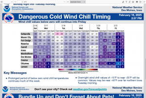
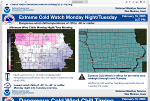
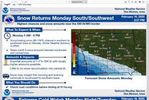
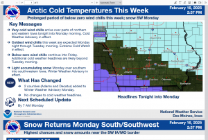
The Des Moines National Weather Service has updated the weather briefing concerning the following hazardous winter weather: Arctic cold temperatures and wind chills should be expected this week, along with snow on Monday over southwestern into southern Iowa. The cold weather will affect the entire State, while the snow will be focused over southwestern and southern Iowa, near the Missouri border. The next scheduled briefing will be available by 7 AM Monday.
Today: Mostly cloudy, cold & blustery with a high near 10. N/NW winds 10-25 mph. Wind chill values as low as -20.
Tonight: Mostly cloudy w/a 30% chance of snow. Low around -1. Wind chill values as low as -10. Little or no snow accumulation expected.
Monday (Washington’s Birthday): Snow likely, mainly before noon. Cloudy and cold, with a high near 8. N/NW winds 5-10. Wind chill values as low as -10. New snow accumulation of 1 to 2 inches possible.
Mon. Night: EXTREME COLD WATCH IN EFFECT from midnight, thru mid-day on Tuesday: Mostly cloudy, with a low around -13. Wind chill values -20 to -35 possible.
Tuesday: Mostly cloudy w/a slight chance of snow. A high near 0.
Tuesday Night: Mostly cloudy, with a low around -10.
Wednesday: Partly sunny and cold, with a high near 2.
Saturday’s High in Atlantic was 27. Our Low this morning, was 4. We had a trace of snowfall in Atlantic after 7-a.m., Saturday. Last year on this date (Feb. 16th), the High in Atlantic was 30 and the Low was 4. The Record High was 64, in 2017, and the Record Low was -33 in 1958. Sunrise: 7:14. Sunset: 5:54.


