
EARLY THIS MORNING…PARTLY CLOUDY WITH ISOLATED THUNDERSTORMS. AREAS OF FOG. SOUTHWEST WIND 5 TO 10 MPH. CHANCE OF THUNDERSTORMS 20 PERCENT.
TODAY…SUNNY. AREAS OF FOG THROUGH MID MORNING. HIGH IN THE MID 70S. WEST WIND AROUND 5 MPH SHIFTING TO THE SOUTHEAST UP TO 5 MPH IN THE AFTERNOON.
TONIGHT…PARTLY CLOUDY. A CHANCE OF SHOWERS AND ISOLATED THUNDERSTORMS OVERNIGHT. LOW IN THE MID 50S. EAST WIND NEAR 5 MPH. CHANCE OF PRECIPITATION 30 PERCENT.
THURSDAY…CLOUDY. A CHANCE OF THUNDERSTORMS IN THE MORNING… THEN THUNDERSTORMS IN THE AFTERNOON. HIGH IN THE LOWER 70S. SOUTHEAST WIND 5 TO 10 MPH. GUSTS UP TO 20 MPH IN THE AFTERNOON. CHANCE OF THUNDERSTORMS 80 PERCENT.
THURSDAY NIGHT…MOSTLY CLOUDY. THUNDERSTORMS LIKELY THROUGH MIDNIGHT. COLDER. LOW IN THE LOWER 40S. NORTHWEST WIND 10 TO 15 MPH WITH GUSTS TO AROUND 25 MPH. CHANCE OF THUNDERSTORMS 70 PERCENT.
FRIDAY…SUNNY…COOLER. HIGH IN THE LOWER 60S. NORTHWEST WIND AROUND 10 MPH. GUSTS UP TO 20 MPH IN THE MORNING.
FRIDAY NIGHT…MOSTLY CLEAR. LOW IN THE UPPER 30S.
Today: Mostly Cloudy w/scattered showers & thunderstorms. High 73. SE @ 10-20.
Tonight: Partly Cloudy to Cloudy w/showers ending. Low 57. S-W @ 10.
Tomorrow: P/Cldy to Cldy. High 72.
Thursday: Mo. Cldy w/showers & tstrms. High 72.
Friday: Isolated showers in the morning; Becoming P/Cldy. High 62.
Monday’s High in Atlantic was 77. Our 24-hour Low (ending today at 7-a.m.) was 46. Last year on this date, our High in Atlantic was 62 and the low was 36. The Record High in Atlantic on this date was 90 in 1938 & 2005. The Record Low was 20 in 1968.
345 AM CDT TUE OCT 4 2016
EARLY THIS MORNING…MOSTLY CLOUDY. WARMER. SOUTHEAST WIND 10 TO 15 MPH WITH GUSTS TO AROUND 25 MPH.
TODAY…PARTLY SUNNY. A CHANCE OF SHOWERS BEFORE NOON. THUNDERSTORMS IN THE AFTERNOON. BREEZY. HIGH IN THE MID 70S. SOUTH WIND 10 TO 20 MPH WITH GUSTS TO AROUND 30 MPH. CHANCE OF PRECIPITATION 90 PERCENT.
TONIGHT…THUNDERSTORMS THROUGH MIDNIGHT…THEN PARTLY CLOUDY WITH A CHANCE OF THUNDERSTORMS AFTER MIDNIGHT. LOW IN THE MID 50S. SOUTH WIND 5 TO 15 MPH WITH GUSTS TO AROUND 30 MPH. CHANCE OF THUNDERSTORMS NEAR 100 PERCENT.
WEDNESDAY…SUNNY. HIGH IN THE MID 70S. WEST WIND AROUND 5 MPH SHIFTING TO THE SOUTH IN THE AFTERNOON.
WEDNESDAY NIGHT…PARTLY CLOUDY THROUGH MIDNIGHT THEN BECOMING MOSTLY CLOUDY. A CHANCE OF SHOWERS AND ISOLATED THUNDERSTORMS. LOW IN THE MID 50S. EAST WIND NEAR 5 MPH. CHANCE OF PRECIPITATION 40 PERCENT.
THURSDAY…THUNDERSTORMS. HIGH IN THE LOWER 70S. EAST WIND 5 TO 15 MPH. CHANCE OF THUNDERSTORMS 90 PERCENT.
THURSDAY NIGHT…THUNDERSTORMS LIKELY THROUGH MIDNIGHT…THEN A SLIGHT CHANCE OF SHOWERS AFTER MIDNIGHT. COOLER. LOW IN THE MID 40S. CHANCE OF PRECIPITATION 70 PERCENT.
FRIDAY…PARTLY SUNNY. COOLER. HIGH IN THE UPPER 50S.
Shelby County Emergency Management Coordinator Bob Seivert said today (Monday), the Fire Danger Index in the County will be “High” this week (10/3-6), due to the dry harvest conditions. Seivert says that means extra precautions should be taken when planning an open burn.
The next update on the County Fire Danger Index will be on Thursday. 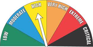
COUNTIES: CARROLL-AUDUBON-GUTHRIE-DALLAS-CASS-ADAIR-MADISON-ADAMS-UNION-
…AREAS OF DENSE FOG EARLY THIS MORNING…
FOR THE THIRD DAY IN A ROW…AREAS OF FOG HAVE DEVELOPED ACROSS
PORTIONS OF CENTRAL IOWA OVERNIGHT. SOME OF THE DENSER FOG BANKS WILL REDUCE VISIBILITY TO BELOW A QUARTER OF A MILE EARLY THIS MORNING…UNTIL DISSIPATING AFTER SUNRISE. DRIVERS SHOULD ALLOW EXTRA TIME FOR TRAVEL AND BE ALERT FOR RAPIDLY CHANGING
VISIBILITY.
Today: Area of morning fog; Partly Cloudy. High 76. SE @ 10-20.
Tonight: P/Cldy to Cloudy. Low 60. S @ 10.
Tomorrow: P/Cldy to Cldy w/scattered showers & thunderstorms. High 72. S @ 10-20.
Wednesday: P/Cldy to Cldy. High 72.
Thursday: Cldy w/shwrs & tstrms. High 68.
Sunday’s High in Atlantic was 75. Our low this morning (thru 7-a.m.) was 46. Last year on this date, the High in Atlantic was 64 and the Low was 35. The All-time Record High in Atlantic on Oct. 3rd was 95 in 1987. The Record Low was 23 in 2010.
AREA COUNTIES: CARROLL-GREENE-AUDUBON-
GUTHRIE-DALLAS-POLK-ADAIR-MADISON-UNION
…PATCHES OF DENSE FOG DEVELOPING AGAIN THIS MORNING…
ONCE AGAIN PATCHY DENSE FOG IS DEVELOPING ACROSS PARTS OF CENTRAL IOWA EARLY THIS MORNING…REDUCING VISIBILITY TO A QUARTER MILE OR LESS AT TIMES. DRIVERS SHOULD BE ALERT FOR RAPIDLY CHANGING VISIBILITY WHEN ENTERING FOG BANKS. CONDITIONS WILL IMPROVE RAPIDLY LATER THIS MORNING AFTER SUNRISE.
Today: Patchy fog before 11am. Otherwise, mostly cloudy, with a high near 71. Calm wind becoming east southeast around 5 mph in the afternoon.
Tonight: Partly cloudy, with a low around 55. Southeast wind 5 to 7 mph.
Monday: Mostly sunny, with a high near 78. Breezy, with a south southeast wind 7 to 16 mph, with gusts as high as 23 mph.
Monday Night: Partly cloudy, with a low around 61. Breezy, with a south southeast wind 11 to 16 mph, with gusts as high as 23 mph.
Tuesday: Showers and thunderstorms likely, mainly after 1pm. Mostly cloudy, with a high near 75. Breezy, with a south wind 15 to 20 mph, with gusts as high as 28 mph. Chance of precipitation is 60%. New rainfall amounts between a tenth and quarter of an inch, except higher amounts possible in thunderstorms.
Tuesday Night: Showers and thunderstorms. Low around 57. Chance of precipitation is 80%. New rainfall amounts between a half and three quarters of an inch possible.
Wednesday: A 30 percent chance of showers. Partly sunny, with a high near 73.
The month of September was warmer, cooler and wetter than average, in Atlantic. Weather stats compiled at the KJAN studios (The OFFICIAL National Weather Service reporting & record-keeping site for Atlantic), reveal the Average High temperature for the month was 80.3-degrees, or 3.9-degrees warmer than normal.
The Average Low temp for the month was 55.7, or 4.6-degrees cooler than normal. Rainfall for September amounted to 6.2-inches. That was 2.39-inches greater than the normal rainfall of 3.81-inches.
The warmest day for the month was Sept. 21st, at 91 degrees. The coolest days were on the 29th and 30th, when we bottomed out at 41. Looking ahead to October, on average, the High for the month is 64.1, while the average Low is 39. Rainfall in October typically amounted to 2.76 inches.
Today: Cloudy, with a high near 68. Calm wind becoming north around 6 mph in the morning.
Tonight: Areas of fog after 2am. Otherwise, mostly cloudy, with a low around 53. Calm wind.
Sunday: Patchy fog before 9am. Otherwise, partly sunny, with a high near 73. Calm wind becoming east southeast around 5 mph in the morning.
Sunday Night: Partly cloudy, with a low around 55. Southeast wind 3 to 5 mph.
Monday: Mostly sunny, with a high near 76. South southeast wind 6 to 14 mph.
Monday Night: Partly cloudy, with a low around 61.
Tuesday: A 40 percent chance of showers and thunderstorms. Mostly cloudy, with a high near 78. Breezy.


