
Here are storm incident & damage reports from the severe storms that passed through Iowa Friday (March 14th). Data collected from Storm Spotters, Emergency Management officials (EMA) and the public, as relayed to the National Weather Service Offices in Des Moines and Omaha. Some local reports are from KJAN (*as noted). You can view the full report from the Dsm NWS Office HERE. The Omaha NWS Office report can be found HERE.

IA DOT hoop bldg in Adair (Photo courtesy Terry Nichols in Adair)

620th S. of Memphis Rd. Cass County, IA (Mike Kennon photo, Cass Co EMA)
Today: Showers and thunderstorms likely, mainly after 5pm. Some of the storms could be severe. High near 74. S/SE winds 20-40 mph.
Tonight: A chance of showers and thunderstorms, mainly before midnight, then a slight chance of rain. Some of the storms could be severe. Low around 37. S winds @ 15-20 becoming west after midnight & gusting to around 30 mph. .
Tomorrow: A chance of rain before 9am, then a slight chance of snow between 9am and 1pm. Cloudy, with a temperature falling to around 38 by 8am. Winds W @ 25-40 mph. Little or no snow accumulation expected.
Tom. Night: Mostly cloudy, with a low around 23. Winds NW @ 15-30 mph.
Sunday: Sunny, with a high near 52.
Sunday Night: Mostly clear, with a low around 37.
Monday: Sunny, with a high near 74.
Tuesday: Mostly sunny, with a high near 77. Breezy.
Thursday’s High in Atlantic was a record breaking 78 degrees. The old record was 74 in 1938. Our Low was 29. Last year on this date (March 14), the High in Atlantic was 71 and the Low was 32. The Record High on this date was 79 in 2012. The Record Low was -11 in 1948 & 1975. Sunrise: 7:37; Sunset: 7:24.
(Radio Iowa) – Forecasters say there’s a rising risk of severe weather across a wide portion of Iowa tomorrow (Friday) afternoon and evening, along with a drastic downshift in temperatures that may bring snow on Saturday. Meteorologist Brian Pierce, at the National Weather Service office in Davenport, says it’s a large, fast-moving system. “The primary risk we’re looking at is the potential for widespread damaging winds,” Pierce says, “but given how the winds are changing with height in the atmosphere, we now cannot rule out the potential for tornadoes to be occurring as well.” Pierce warns Iowans to be “weather aware” tomorrow, especially between 5 and 11 P-M.
“Be paying attention to the weather that’s going on around you,” Pierce says, “and the fact that these storms are going to be moving at highway speeds means you will have less time to react as they approach you.” A powerful blizzard swept across Iowa last Wednesday, knocking out the lights to more than 20-thousand Iowa houses and bringing traffic to a standstill with whiteout conditions. Pierce says this approaching system may be even worse. “The center of the storm system, which is going to be going through western Iowa, is very strong, comparable to the one we saw about a week or so ago, possibly even stronger,” Pierce says, “and so because of that, it will be bringing up moisture into the area, and the winds aloft are also very strong as well.” 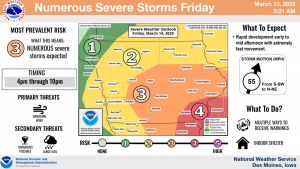
While most of Iowa can expect high temperatures in the 70s today and tomorrow, Pierce says this incoming storm will bring much colder weather behind it. Lows by Saturday night will be in the 20s, with snow possible. “The snowfall is probably going to be more or less the western half of Iowa, but we can’t rule out some flakes falling in eastern Iowa as well,” Pierce says. “As for amounts, eastern Iowa is probably an inch at the very worst. It may actually be no more than a dusting.” Any snow that falls won’t last long, as the forecast calls for much of Iowa to be in the 40s by Sunday and the 50s on Monday.
(Updated 4:30-a.m.)
Today: Sunny, with a high near 75. East wind 5 to 10 mph this morning becoming southerly this afternoon.
Tonight: Partly cloudy, with a low around 51. S/SE @ 10-20 w/gusts as high as 25 mph.
Friday: Showers and thunderstorms likely, mainly after 4pm. Otherwise mostly sunny & windy, with a high near 75. S/SE winds 20-40 mph. New rainfall amounts between a tenth and quarter of an inch, except higher amounts possible in thunderstorms.
Friday Night: A chance of showers and/or thunderstorms. A low around 36.
Saturday: A chance of rain before 4pm, then a slight chance of snow. A high near 45. W/NW winds 20-35 mph. Little or no snow accumulation expected.
Sunday: Sunny, with a high near 50.
Monday: Sunny, with a high near 71. Breezy.
Tuesday: Mostly sunny, with a high near 68. Breezy.
Wednesday’s High in Atlantic was 71. The Low was 24. Last year on this date (March 13), the High in Atlantic was 67 and the Low was 31. The Record High on this date was 74 in 1938. The Record Low was -21 in 1998. Sunrise: 7:37; Sunset: 7:23.
Today: Mostly sunny, with a high near 69. E/SE breeze at around 5 mph in the afternoon.
Tonight: Mostly cloudy early, then gradually becoming clear, with a low around 37. East wind 5 mph.
Tomorrow: Sunny, with a high near 75. E/SE winds 5-15 mph becoming S & gusting to near 20 mph.
Tom. Night: Partly cloudy & breezy, with a low around 52.
Friday: Cloudy & windy w/showers and possibly a thunderstorm after 1pm. High near 74. .
Friday Night: Rain. Low around 34.
Saturday: A chance of rain and/or snow. High near 44.
Saturday Night: Mostly cloudy, with a low around 22. Blustery.
Sunday: Sunny & breezy, with a high near 45.
Tuesday’s High in Atlantic was 58 degrees. Our Low was 24. Last year on this date (March 12th), the High in Atlantic was 74 and the Low was 41. The Record High for March 12th was 74 in 2024. The Record Low was -22 in 1948. Sunrise: 7:39. Sunset: 7:22.
Today: Sunny, with a high near 55. North northeast wind 10 to 25 mph.
Tonight: Mostly clear, with a low around 33. East northeast wind 5 to 10 mph.
Wednesday: Mostly sunny, with a high near 68. East wind @ around 5 mph.
Thursday: Sunny, with a high near 73.
Friday: A 60% chance of showers & possible thunderstorms, otherwise mostly sunny & windy, w/a high near 75.
Saturday: Partly sunny & windy, w/a 30% chance of rain before 1pm. A high near 48.
Monday’s High in Atlantic broke a record set in 1986, when we topped-out at 78 degrees. The old record high was 76. Our Low was 25. Last year on this date (March 11th), the High in Atlantic was 61 and the Low was 17. The Record High for March 11th was 76 in 2021. The Record Low was -8 in 1948. Sunrise: 7:41. Sunset: 7:21.
(Radio Iowa) – Moderate drought conditions expanded slightly last month in central and eastern Iowa, according to the state’s latest Water Summary Update. Jessica Reese McIntyre, an environmental specialist with the Iowa D-N-R, says she’ll be watching closely for worsening drought conditions, but she adds, winter is typically the driest time of the year in Iowa.
McIntyre says, “In the month of February, we saw another month of below-average precipitation, just as we did in January.” The state’s average snowfall in February was four-point-eight inches, nearly two inches below normal. “While this could raise concerns about potential drought conditions worsening, it’s still winter,” she says, “and winter is when we receive the least amount of precipitation across the state, and also, the ground is still frozen.”
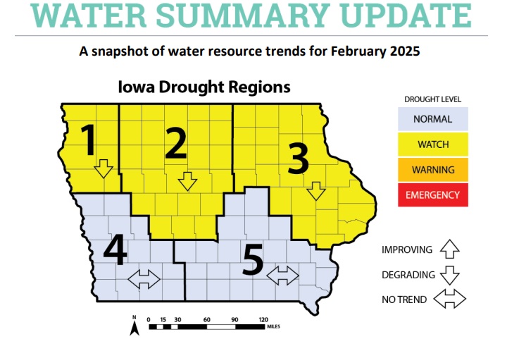
Iowa DNR graphic
The National Weather Service forecast for March indicates a slight chance for above-average precipitation in the eastern half of Iowa and average precipitation in the western half.
Today: Sunny & windy, with a high near 75. **RED FLAG WARNING for critical fire weather conditions, from Noon until 8-p.m.** Winds S/SW @ 10-20 mph w/gusts to near 30 mph.
Tonight: Clear, with a low around 32. W/SW winds 10-20. shifting to the N after midnight.
Tomorrow: Sunny & breezy, with a high near 54. N/NW winds 10-25 mph.
Tom. Night: Partly cloudy, with a low around 33. East wind 5 to 10 mph.
Wednesday: Mostly sunny, with a high near 67.
Thursday: Sunny, with a high near 73.
Friday: A 40% chance of showers after 1pm, otherwise mostly sunny & windy, with a high near 74.
Sunday’s High in Atlantic was 63. The Low was 21. Last year on this date (March 10th), the High in Atlantic was 47 and the Low was 17. The Record High for March 10th was 76 in 1986. The Record Low was -10 in 1912. Sunrise: 7:45. Sunset: 7:19.
Today: Sunny, with a high near 61. Light west wind becoming west southwest 5 to 15 mph in the morning. Winds could gust as high as 20 mph.
Tonight: Clear, with a low around 32. Southwest wind 5 to 10 mph.
Monday: Sunny & breezy, with a high near 74. **FIRE WEATHER WATCH for elevated fire weather conditions**S/SW winds 5-10 mph in the morning, gusting to near 30 in the afternoon.
Monday Night: Mostly clear, with a low around 32. SW winds becoming N/NW @ 10-20.
Tuesday: Mostly sunny, with a high near 51. Winds N @ 10-20 mph.
Tuesday Night: Partly cloudy, with a low around 33.
Wednesday: Mostly sunny, with a high near 64.
Thursday: Sunny, with a high near 72.
Saturday’s High in Atlantic was 51. The Low was 21. Last year on this date (March 9th), the High in Atlantic was 38 and the Low was 21. The Record High for March 9th was 76 in 1986. The Record Low was -12 in 1982. Sunrise: 7:45. Sunset: 7:18.
Today: Sunny, with a high near 49. West southwest winds 8 to 11 mph.
Tonight: Mostly clear, with a low around 24. West wind 3 to 7 mph.
Tomorrow: Sunny, with a high near 59. Light west wind becoming southwest @ 6 to 11 mph in the morning.
Monday: Sunny & breezy, with a high near 72. Breezy, with a light southwest wind increasing to 12 to 17 mph in the morning. Winds could gust as high as 24 mph.
Tuesday: Mostly sunny, with a high near 53.
Wednesday: Mostly sunny, with a high near 63.
Friday’s High in Atlantic was 37. The Low was 19. Last year on this date (March 8th), the High in Atlantic was 58 and the Low was 30. The Record High for March 8th was 78 in 2000. The Record Low was -11 in 1982. Sunrise: 6:45. Sunset: 6:17.


