
(Radio Iowa) – Blizzard conditions have shut down roadways and travel is not recommended in many areas of western and northwestern Iowa this afternoon. D-O-T Winter Operations Director Craig Bargfrede says a large area is impacted. “If you draw a line basically from just north of Council Bluffs, kind of in the Missouri Valley area, and then do a diagonal up through Carroll Fort Dodge Mason City, pretty much that area, along that line and just north of that line. Interstate 29 is closed in both directions between Sergeant Bluff and Missouri Valley.
Bargfrede says they are working on getting some of the vehicles there removed as there are power lines down on the interstate. He says electric crews can’t get in to work on the power lines until they get cars out of the way. Bargfrede says there are a lot of semis and other cars that have blocked roads as the storm blew through. “We didn’t close the roads, the roads closed themselves due to incidents and vehicles and trucks basically getting stuck and stranded in those areas,” he says. Bargfrede says they have NOT pulled any crews off the roadways.
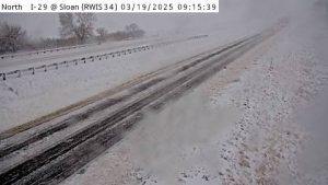
IA DOT traffic cam I-29 near Sloan
“We’re continuing to plow and trying to get in there as best we can and at least free those vehicles,” Bargfrede says. “There are some towing bans in place up in that same area. So, what that means if the vehicle is down in the right of way, not in the traveled portion of the highway, it’s probably going to remain there until conditions have improved.” He says the snow missed much of the rest of the state as it curled up north.
“Get into the Des Moines and on into like, say, Iowa City, Coralville, Cedar Rapids area, into the Quad Cities. Conditions are are much better, still seeing wind, still seeing some off and on showers in that area, but not the snow. It’s pretty dramatic drop off from where we’re seeing the significant snow till there’s basically nothing other than wet payment,” Bargfrede says.
Bargfrede says crews will keep working as long as needed to clear the roadways.
(Radio Iowa) – The last day of winter is going out with a blizzard. Forecasters say a storm system will drop up to a foot of snow across a long stretch of Iowa today (Wednesday), from the southwest to north-central Iowa, with winds gusting up to 65 miles an hour. National Weather Service meteorologist Rod Donavon says some areas are seeing rain showers this morning, but that will change over to snow across the state’s northwestern half. “That trend will continue throughout the day today, as we do have a band of heavy snow that we are expecting to develop basically from near Mason City, it’s going to be pretty close to the Fort Dodge area, out by Algona, off to the southwest towards Denison.” The blizzard warning covers 34 counties through tonight and Donavon says white-out conditions are possible which could make driving very dangerous.
“We are looking at a snow band anywhere from six-to-ten, even eight-to-12 inches through that region,” Donavon says. “In addition, we are expecting extremely strong winds to develop today. We’re expecting wind gusts of 55 to 65 miles per hour. Anywhere within that heavy snow band, travel is going to become impossible at some point today, with multiple roads becoming closed through that region.” More foul weather could be headed our way, though Donavon says it’s continuing to evolve.
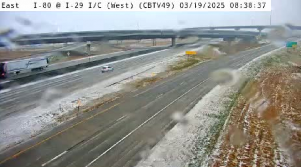
Iowa DOT camera screenshot: I-80: CB – I-80 @ West I-29 Interchange (West) (49) as of 8:38-a.m. March 19th
“We’re still monitoring this one storm system coming through around Friday/Friday night that may bring another round,” he says. “Right now, we have rain in the forecast, but we could see some gusty winds with that, maybe a brief transition to snow on the backside of that, but otherwise, we’re going to get back a little bit more normal, with highs within that snow band lingering in the 40s.”
By the weekend, forecasters say high temps may be back in the 50s.
Today: WINTER WEATHER ADVISORY from 7-a.m. until 10-p.m.* HIGH WIND WARNING from 7-a.m. until 7-p.m.*Rain and snow, possibly mixed with sleet, becoming all snow this noon. Some thunder is also possible. Widespread blowing snow, mainly after 5pm. Temperature falling to around 32 by 4pm. Winds N @ 30-60 mph. New snow and sleet accumulation of 1 to 3 inches possible.
Tonight: A 30% chance of snow, mainly before 8pm. Widespread blowing snow, mainly before 7pm. Cloudy to partly cloudy. Low around 22. N/NW winds 30-50 decreasing after midnight. New snow accumulation of less than a half inch possible.
Tomorrow: Sunny, with a high near 47. NW winds becoming W/SW @ 10-20 mph. o.
Tom. Night: Partly cloudy, with a low around 33. South winds 15-25 mph.
Friday: Partly sunny & breezy w/a slight chance of rain after 1pm. A high near 54.
Friday Night: Partly cloudy, with a low around 24.
Saturday: Mostly sunny, with a high near 59.
Tuesday’s High in Atlantic was 78. The Low was 37. We had received just a trace of rain at KJAN early this morning. Last year on this date (3/19) the High in Atlantic was 39 & the Low was 21. The Record High was 81 in 2012. The Record Low was -1 in 1893. Sunrise: 7:27; Sunset: 7:30.
(Radio Iowa) – Forecasters say travel could be difficult if not impossible across Iowa’s northwestern third tomorrow (Wednesday). Blizzard conditions are in the forecast for some 30 counties with winds gusting up to 65 miles an hour and heavy snow of up to twelve inches in some areas. National Weather Service meteorologist Alexis Jimenez says the storm front will start moving into Iowa late tonight and early tomorrow.
“We’re expecting that precipitation to come in after about one o’clock in the morning,” Jimenez says. “That’s going to be primarily rain and thunderstorms in the southeastern half of the state, and maybe some thunderstorms mixing in more on the north side, where there’s going to be snow, so that means ‘thunder-snow’ for those that like that.” A major temperature shift is coming to the region, as highs today are forecast mostly in the 60s and 70s across Iowa, but the approaching storm system will bring in very cold air. 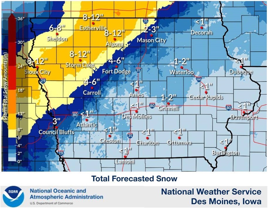
“Rain will gradually transition to all snow as we get into Wednesday morning especially,” Jimenez says, “and with those winds up to about 65 miles per hour, especially up there in northern Iowa, you can have some blizzard conditions pretty likely up there and white-out conditions are likely with that.”
Some areas may see snowfall at the rate of two inches per hour. Coincidentally, tomorrow’s the last full day of winter.
Today: Mostly sunny, with a high near 75. E/NE winds 10-20 this morning shifting to the south this afternoon.
Tonight: Mostly cloudy & windy, w/a 60% chance of showers & thunderstorms after midnight. Low around 33. S-N/NE @ 15-35 mph.
Tomorrow: Winter Storm Watch in effect from 7-a.m. through 10-p.m. Snow, possibly mixed with rain, becoming all snow after 4pm. Some thunder is also possible. High around 37, with the temperature falling during the afternoon. HIGH WIND WARNING from 7-a.m. until 7-p.m. Winds N @ 30-60 mph. New snow accumulation of less than one inch is expected.
Tom. Night: A slight chance of snow. Low around 20. N/NW winds 25-40 mph. decreasing after midnight.
Thursday: Sunny, with a high near 48. NW-W/SW @ 10.
Thursday Night: Mostly cloudy, with a low around 35.
Friday: A 30 percent chance of rain after 1pm. Mostly cloudy, with a high near 57.
Monday’s High in Atlantic was 80. The Low was 39. Last year on this date (3/18) the High in Atlantic was 38 & the Low was 14. The Record High was 84 in 1894. The Record Low was -11 in 1906. Sunrise: 7:29; Sunset: 7:29.
(Radio Iowa) – The first day of spring is Thursday and many Iowans may have snow on the ground when the new season arrives. Forecasters predict drastic changes in the weather this week, as today’s (Monday) high temperatures are expected mostly in the 60s and 70s. Meteorologist Brad Small, at the National Weather Service, says open burning is strongly discouraged across a wide area of Iowa. “With warm temperatures today, breezy conditions, low humidities and drying grasses still are going to result in conditions favorable for fires to spread pretty quickly,” Small says, “so we have a Red Flag Warning in effect for much of central and southern Iowa due to critical fire weather conditions.”
The final days of winter, however, may look radically different, as some four-dozen Iowa counties are under a Winter Storm Watch for tomorrow (Tuesday) night and Wednesday. “We’re looking at the potential for moderate to heavy snowfall accumulations, and that snow will be combined with very strong winds. Winds could gust to 50 miles per hour more,” Small says. “We’re back to the potential for a blizzard and travel to be hazardous, if not impossible at times. It looks like it may be a fairly impactful storm.”
Snowfall could range from two to eight inches, and it won’t be around long, as Small says highs on Thursday should be back in the 40s and 50s.
(UPDATED) Today: **RED FLAG WARNING from 11-a.m. until 8-p.m.**Sunny & windy, with a high near 77. S/SW winds 15-30 mph.
Tonight: Partly cloudy, with a low around 45. S/SW winds becoming N/NE @ 5-15 mph w/gusts to around 25.
Tomorrow: Mostly sunny, with a high near 76. East winds 10 to 15 mph becoming S/SW w/gust to 20 mph.
Tom. Night: A slight chance of showers & thunderstorms. Low around 38. E/SE @ 15-40 mph becoming N/NE. **WINTER STORM WATCH 4-A.M. WED. UNTIL 1-A.M. THURSDAY**
Wednesday: **Winter Storm Watch**Snow, possibly mixed with rain, becoming all snow after 1pm. Some thunder is also possible. Very windy w/areas of blowing snow after noon. High near 40.
Wed.: Partly cloudy w/patchy blowing snow. Low around 21.
Thursday: Sunny, with a high near 50.
Sunday’s High in Atlantic was 51. The Low was 21. Last year on this date (3/17) the High in Atlantic was 53 & the Low was 24. The Record High was 84 in 2015. The Record Low was -4 in 1900. Sunrise: 7:31; Sunset: 7:27.
Today: Sunny, with a high near 50. N/NW winds 10-25 mph. Wind chill values as low as 10 early.
Tonight: Mostly clear, with a low around 36. South winds 15-20 mph.
Monday: Sunny & breezy, with a high near 77. S/SW winds 15-25 mph.
Monday Night: Partly cloudy, with a low around 45.
Tuesday: Mostly sunny, with a high near 74. S/SE winds @ 10-20 mph becoming SW in the afternoon.
Tue. Night: Windy w/a chance of rain before 1am, then rain and snow. Low around 29. Windy.
Wednesday: Windy. Snow, possibly mixed with rain before 1pm, then a chance of snow. High near 40.
Thursday: Sunny, with a high near 49.
Saturday’s High in Atlantic was 38. Our Low this morning, 22. Last year on this date (3/16) the High in Atlantic was 56 & the Low was 34. The Record High was 79 in 2003. The Record Low was 0 in 1944. Sunrise: 7:32; Sunset: 7:26.
(Atlantic, Iowa) – Severe storms that raced across Nebraska and Iowa late Friday afternoon and night pummeled some area with damaging winds and hail. Here in Cass County, the damage reports started coming in at around 5:15-p.m., when a large roof was ripped-off of a shed or outbuilding and landed on 620th Street near Memphis Road, south of Atlantic. Winds at the time gusted to near 70 miles per hour (mph). Cass County Emergency Management Coordinator Mike Kennon reported 620 was completely blocked by the debris. The road was partially re-opened about an hour later.
A semi was toppled onto its side while on an off-ramp from I-80 westbound at mile marker (mm) 54, in Cass County. Unknown if there were any injures. Another semi was blown-off the road east of Manilla, in Crawford County. The driver was said to have been okay. And, an empty cattle hauling tractor-trailer was blown-over near Lytton, in Calhoun County.
In Adair, an Iowa Department of Transportation hoop-style building used to store sand and salt was ripped to shreds. A large plastic, empty water storage container was tossed into the air and landed near the business.

Guthrie Center, IA (Photo via the Iowa Storm Chasing Network’s Facebook page)
In Guthrie Center, the roofs of some buildings in the downtown area were torn-off by severe thunderstorm winds. A large tree was blown over onto a house near the Des Moines International Airport, Friday evening. Power poles were snapped-off in Carroll County, near Maple River.
In Montgomery County, firefighters from Red Oak, Grant and Elliott were dispatched just before 5-p.m., Friday, to the 1500 block of M Avenue, for a report of downed powerlines and a ditch fire that was spreading quickly due to the storm winds. Fire crews were able to contain the fire and stop it from spreading to some near by structures. MidAmerican Utilities responded to the scene to restore the powerlines. No injuries were reported.

Red Oak FD Facebook page photo
Scattered incidents of hail ranging in size from small marbles to as big as ping-pong balls, were reported as well. Quarter-size hail was reported to have fallen in or near Brayton. Ping-pong ball-size hail occurred in Adair and near Ames.
You can view the full storm incident and damage reports through links to the Omaha and Des Moines National Weather Service Offices, on the “Severe Storm report” story on the Weather page at kjan.com. (Here are some photo’s we’ve received):

IA DOT hoop bldg in Adair (Photo courtesy Terry Nichols in Adair)

620th S. of Memphis Rd. Cass County, IA (Mike Kennon photo, Cass Co EMA)

Near Manilla (From our sister station KDSN)
Today: Mostly cloudy & windy w/a slight chance of rain this morning. A nearly steady temperature around 44. Winds W @ 21-25 mph, with gusts as high as 34 mph.
Tonight: Mostly cloudy early, then gradually becoming mostly clear. Low around 24. N/NW winds 13-18 mph, with gusts as high as 29 mph.
Sunday: Sunny, with a high near 51. North northwest wind 8-10 mph. with gusts as high as 18 mph.
Sunday Night: Mostly clear, with a low around 33. South wind 5 to 14 mph, with gusts as high as 22 mph.
Monday: Sunny, with a high near 73. Breezy, winds S/SW @ 14-20 mph/ Gusts as high as 26 mph.
Tuesday: Mostly sunny & breezy, with a high near 75. Breezy.
Tue. Night: A chance of rain through midnight, then a rain-snow mix. Windy. Low around 29. Chance of precipitation is 60%.
Wednesday: A 70% chance of snow. Windy. High around 39.
Friday’s High in Atlantic was 75. Our Low this morning, 37. We received .04″ Friday. Last year on this date (3/15/) the High in Atlantic was 50 & the Low was 35. The Record High was 78 in 2012. The Record Low was -12 in 1975. Sunrise: 7:34; Sunset: 7:25.


