
Baseball Camps for Atlantic Little League have been cancelled for today (4/19)
The entire state is under the threat for severe thunderstorms later today (Wednesday). National Weather Service Meteorologist Cory Martin says the system is expected to enter western Iowa late this afternoon and push east through the evening and into the early overnight hours. “All modes of severe weather are possible including large hail, strong wind gusts, and also the possibility of a few tornadoes,” Martin said.
The biggest tornado threat appears to be over west-central and southwest Iowa, according to Martin. Heavy rain is also likely. “It remains to be seen if it’s going to lead to any flash flooding concerns. It looks like the storms will be moving at a decent clip. That would alleviate any threat for flash flooding, but it’s something that we’ll monitor,” Martin said.
Dry and cooler conditions are expected for the remainder of the work week and into the weekend.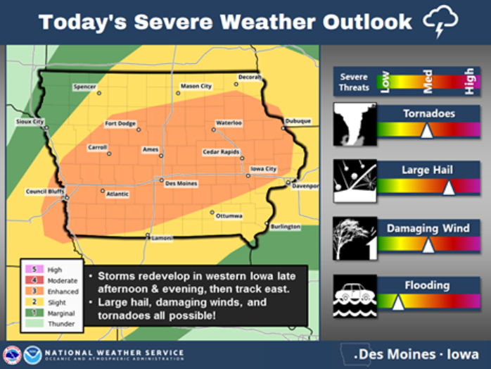
(Radio Iowa)
AREA COUNTIES: Audubon-Guthrie-Dallas-Cass-Adair-Madison-Adams-Union-Taylor-Ringgold-934 AM CDT Wed Apr 19 2017
…FLASH FLOOD WATCH IS CANCELLED...
The Flash Flood Watch for portions of central Iowa, south central Iowa, southeast Iowa, southwest Iowa, and west central Iowa has been cancelled. Rainfall last night was lighter and less widespread than expected. Thus the flash flood threat has
diminished. Local minor flooding is possible later today into tonight due to additional thunderstorms. Widespread flash flooding is not expected however.
Today: FLASH FLOOD WATCH until 1-a.m. Thursday; Scattered showers & thunderstorms. High 70. SE @ 15-25.
Tonight: Scattered shwrs & tstrms. Low 48. S-NW @ 10-15.
Tomorrow: P/Cldy. High 62. NW @ 10-20.
Friday: P/Cldy High 62.
Saturday: P/Cldy to Cldy. High around 62.
Tuesday’s High in Atlantic was 67. Our Low this morning (as of 5:15-a.m.) was 52. We have also received .35” of an inch of rain from yesterday (.19”) and early this morning (.16”) at the KJAN studios. Last year on this date, the High in Atlantic was 62 and the low was 44. The Record High in Atlantic on this date was 87 in 1908, 1946 & 1987. The Record Low was 15 in 1988.
ANAMOSA, Iowa (AP) – The National Weather has confirmed that a tornado destroyed and damaged buildings in a rural part of eastern Iowa’s Jones County.
The service rated Saturday night’s twister at EF1 with winds estimated at 100 mph. The twister touched down about 4 miles northeast of Anamosa and ran 3 miles east. It flattened or damaged farm buildings at two locations before lifting. No injuries were reported.
The first corn seeds got into the ground last week, but weather has kept most farmers out of the fields. The U-S-D-A’s week crop report says there were just three days suitable for fieldwork last week thanks to wet weather. Soil temperatures that are warm enough for planting have also been an issue. But there were some farmers who pulled the planter into the field — and two percent of the new crop is now in the ground. The crop report says this year’s start is five days behind last year and three days behind the five-year average for corn planting.
(Radio Iowa)
Today: P/Cldy to Cldy w/scattered shwrs & tstrms. High 73. S @ 10-20.
Tonight: Scattered shwrs & tstrms. Low 57. NE @ 5-10.
Tomorrow: Scatt. Shwrs & tstrms. High 74. SE @ 10-20.
Thursday: Mo. Cldy High 60.
Friday: Mo. Cldy. High 62.
Monday’s High in Atlantic was 73. Our 24-hour Low was 41. Last year on this date, the High in Atlantic was 64 and the low was 44. The Record High in Atlantic on this date was 89 in 1948. The Record Low was 17 in 1905.
Recent rainfall events have dampened the fields and grassland areas to the point where the Shelby County Emergency Management Agency has reduced the field and grassland fire danger index from High to LOW.
Even though the fire danger rating is Low, you are asked to call-in and report your burning projects to Shelby County Dispatch at 712-755-2124, and, notify your local Fire Chief.
Today: P/Cldy to Cldy. High 72. E @ 5-10.
Tonight: Scattered shwrs & tstrms possible late. Low 57. SE @ 5-10.
Tomorrow: Scatt. Shwrs & tstrms. High 70. S-NW @ 10-15.
Wednesday: Shwrs & tstrms. High 65.
Thursdsay: P/Cldy. High 60.
Sunday’s High in Atlantic was 73. Our Low this morning 42. Last year on this date, the High in Atlantic was 76 and the low was 57. The Record High in Atlantic on this date was 85 in 2004. The Record Low was 11 in 1907.


