
Today: Cloudy this morning w/scattered light rain; Becoming P/Sunny. High 61. NW @ 15-25.
Tonight: P/Cldy. Low 36. NW @ 5-15.
Tomorrow: P/Cldy. High 61. E @ 5-10.
Saturday: P/Cldy High 63.
Sunday: P/Cldy. High 68.
Wednesday’s High in Atlantic was 78. Our Low this morning (as of 5:30-a.m.) was 48. We have also received a total of .17” of an inch of rain yesterday and last night, here at the KJAN studios. Last year on this date, the High in Atlantic was 58 and the low was 49. The Record High in Atlantic on this date was 90 in 1902. The Record Low was 18 in 1956.
Officials with the National Weather Service say a Storm Chaser reported a tornado on the ground about two-miles southwest of Carroll, Wednesday night. The event that took place at around 8-p.m., resulted in downed trees, and damage to some outbuildings. About four-minutes later, the Carroll County 9-1-1 Dispatch Center received reports the roof and doors were blown off a machine shed two-miles south/southeast of Carroll.
Just before 8-p.m., a trained storm spotter reported a tornado caused damage in the Carroll County town of Halbur, including downed power lines and an overturned camper. Power poles also were toppled near Randall in Hamilton County, which is northeast of Carroll.
Nickel-to quarter-size hail was reported in the Shelby County town of Panama, at around 7:40-p.m., Wednesday. Penny-sized (3/4″) hail fell four-miles southwest of Missouri Valley at around 7:14-p.m.
And, 60-mile per hour winds were reported just northwest of Scranton, in Greene County, a little after 8:30-p.m., along with pea-size hail and water ponding in the streets. There were no immediate reports of injuries associated with the storms.
The National Weather Service has cancelled the Tornado Watch for Audubon and Carroll Counties. The watch remains in effect until 10-p.m for Adair Adams Cass Guthrie and Taylor Counties.
THE NATIONAL WEATHER SERVICE HAS CANCELLED TORNADO WATCH 148 FOR THE FOLLOWING AREAS:
IN IOWA THIS CANCELS 6 COUNTIES…..
IN SOUTHWEST IOWA
FREMONT HARRISON MILLS
POTTAWATTAMIE SHELBY
IN WEST CENTRAL IOWA
MONONA
845 PM CDT WED APR 19 2017
The National Weather Service in Des Moines has issued a
* Severe Thunderstorm Warning for…
Central Cass County in southwestern Iowa…
Adair County in southwestern Iowa…
* Until 930 PM CDT.
* At 845 PM CDT, a severe thunderstorm was located 8 miles southeast
of Atlantic, moving northeast at 40 mph.
HAZARD…60 mph wind gusts and quarter size hail.
SOURCE…Radar indicated.
IMPACT…Hail damage to vehicles is expected. Expect wind damage
to roofs, siding, and trees.
* Locations impacted include…
Greenfield, Anita, Adair, Fontanelle, Lewis, Massena, Cumberland,
Bridgewater, Wiota, Lake Anita State Park, Greenfield Municipal
Airport, Nodaway Park, Cold Springs State Park and Anita Municipal
Airport.
This includes Interstate 80 between mile markers 71 and 85.
PRECAUTIONARY/PREPAREDNESS ACTIONS…
Remain alert for a possible tornado! Tornadoes can develop quickly
from severe thunderstorms. If you spot a tornado go at once into the
basement or small central room in a sturdy structure.
For your protection move to an interior room on the lowest floor of a
building.
814 PM CDT WED APR 19 2017
The National Weather Service in Des Moines has issued a
* Severe Thunderstorm Warning for…
Southwestern Greene County in west central Iowa…
Guthrie County in west central Iowa…
Audubon County in west central Iowa…
Southeastern Carroll County in west central Iowa…
* Until 900 PM CDT.
* At 814 PM CDT, a severe thunderstorm was located 7 miles north of
Audubon, moving east at 45 mph.
HAZARD…60 mph wind gusts and quarter size hail.
SOURCE…Radar indicated.
IMPACT…Hail damage to vehicles is expected. Expect wind damage
to roofs, siding, and trees.
* Locations impacted include…
Jefferson, Audubon, Guthrie Center, Coon Rapids, Panora, Lake
Panorama, Exira, Elk Horn, Scranton, Bayard, Kimballton, Bagley,
Dedham, Yale, Jamaica, Brayton, Gray, Jefferson Municipal Airport,
Lakin Slough Game Management Area and Audubon County Airport.
PRECAUTIONARY/PREPAREDNESS ACTIONS…
Remain alert for a possible tornado! Tornadoes can develop quickly
from severe thunderstorms. If you spot a tornado go at once into the
basement or small central room in a sturdy structure.
For your protection move to an interior room on the lowest floor of a
building.
723 PM CDT WED APR 19 2017
THE NATIONAL WEATHER SERVICE HAS EXTENDED TORNADO WATCH 148 TO INCLUDE THE FOLLOWING AREAS UNTIL 10 PM CDT THIS EVENING IN IOWA THIS WATCH INCLUDES 3 COUNTIES IN WEST CENTRAL IOWA: CARROLL CRAWFORD GREENE
THIS INCLUDES THE CITIES OF CARROLL, DENISON, AND JEFFERSON.
* PRIMARY THREATS INCLUDE…
A FEW TORNADOES LIKELY.
SCATTERED LARGE HAIL AND ISOLATED VERY LARGE HAIL EVENTS TO 2.5 INCHES IN DIAMETER LIKELY. ISOLATED DAMAGING WIND GUSTS TO 70 MPH POSSIBLE.
TORNADO WATCH 148 REMAINS VALID UNTIL 10 PM CDT THIS EVENING FOR THE FOLLOWING AREAS: ADAIR ADAMS AUDUBON CARROLL CASS CRAWFORD FREMONT GREENE GUTHRIE HARRISON MILLS MONONA MONTGOMERY PAGE POTTAWATTAMIE SHELBY TAYLOR
Severe Thunderstorm Warning
National Weather Service Omaha/Valley Nebraska
728 PM CDT WED APR 19 2017
The National Weather Service in Omaha has issued a
* Severe Thunderstorm Warning for…
Northeastern Harrison County in southwestern Iowa…
Shelby County in southwestern Iowa…
* Until 800 PM CDT
* At 728 PM CDT, a severe thunderstorm was located 9 miles northeast
of Logan, or 25 miles southwest of Denison, moving east at 35 mph.
HAZARD…60 mph wind gusts and quarter size hail.
SOURCE…Radar indicated.
IMPACT…Hail damage to vehicles is expected. Expect wind damage
to roofs, siding, and trees.
* Locations impacted include…
Harlan, Earling, Irwin, Defiance, Woodbine, Panama, Portsmouth,
Westphalia, Kirkman and Schaben Park.
This includes Highway 59 IN Iowa between mile markers 80 and 89.
PRECAUTIONARY/PREPAREDNESS ACTIONS…
For your protection move to an interior room on the lowest floor of a
building.
The National Weather Service has issued Tornado Watch #148 in effect until 10-p.m. for the following area Counties ADAIR ADAMS AUDUBON CASS FREMONT GUTHRIE HARRISON MILLS MONONA MONTGOMERY PAGE POTTAWATTAMIE SHELBY TAYLOR.
The Primary threats include a few likely tornadoes, scattered large hail, and isolated very large hail events to 2.5-inches in diameter. Isolated damaging wind gusts of up to 70-mph are also possible. 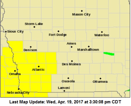
Tornado probability:
2 or more tornadoes = 60%
1 or more strong tornadoes (F-2 to F-5) = 20%
10 or more severe wind events + 20%
1 or more wind events exceeding 75 mph = 10%
10 or more severe hail events = 60%
1 or more hail events (>2″) = 60%
hail/wind events = 90%


