
(Radio Iowa) – A statewide tornado drill was held at 10 a-m today (Wednesday) as part of Severe Weather Awareness Week. National Weather Service meteorologist Peter Rogers says if you weren’t able to participate this is an excellent opportunity to review your safety procedures and ensure you’re prepared. Rogers says we often talk about having an emergency kit on hand in the winter, but it’s also important in spring and summer as well. “What would you do if you happen to need to be at your home for multiple days, if you got cut off, or, God forbid, if you actually had to evacuate your home? What kind of what kind of belongings would you want to bring with you?,” he says.
“Obviously, food and water comes to the top of the mind, but then there’s a lot of other additional things that you’re probably going to want to have.” Rogers says it’s also important to coordinate with family members so you know each other’s whereabouts if a storm hits. “Figure out where people are, what they need to do, where they need to go, and so those are all things that, again, would be a great thing to be discussing at this time of the year, before we get into the heart of severe weather season,” he says. 
Rogers says plan now and you can avoid a lot of confusion and concern if severe weather does hit your home or neighborhood.
Today: Mostly sunny, with a high near 65. Calm wind becoming southwest 5 to 10 mph this afternoon.
Tonight: Mostly cloudy w/a 40%chance of rain through midnight, then a chance of showers and thunderstorms. Low around 44. Winds S @ 10-20 mph. New rainfall amounts of less than a tenth of an inch, except higher amounts possible in thunderstorms.
Tomorrow: A 40% chance of showers and thunderstorms, otherwise mostly sunny. High near 70. S/SE winds 5-10 mph. New rainfall amounts between a quarter and half of an inch possible.
Tom. Night: A 40% chance of showers and thunderstorms; Partly cloudy, with a low around 54.
Friday: Sunny & windy, with a high near 79.
Saturday: Showers and possibly a thunderstorm. Breezy. High near 64.
Sunday: A 50% chance of rain. Breezy & cooler. A high near 47.
Tuesday’s High in Atlantic was 61. The Low was 22. Last year on this date (3/26) the High in Atlantic was 64 & the Low was 29. The Record High was 91 in 1907. The Record Low was 5 in 1894. Sunrise: 7:15; Sunset: 7:37.
Today: Mostly sunny, with a high near 61. Northwest winds 10-25 mph.
Tonight: Mostly clear, with a low around 32. Northwest wind 5 to 10.
Tomorrow: Sunny, with a high near 63. Winds westerly at 5 to 10 mph in the morning.
Tom. Night: A slight chance of rain after midnight. Low around 42.
Thursday: A chance of showers, with thunderstorms also possible, late. Otherwise mostly sunny. A high near 73.
Thursday Night: A 30% chance of rain and thunderstorms. Low around 55.
Friday: Sunny & windy, with a high near 79.
Monday’s High in Atlantic was 56. The Low was 23. Last year on this date (3/25) the High in Atlantic was 48 & the Low was 34. The Record High was 83 in 1967. The Record Low was -2 in 1974. Sunrise: 7:17; Sunset: 7:36.
Today: Mostly cloudy, with a high near 58. Light west wind becoming southwest 5 to 10 mph this morning.
Tonight: Cloudy during the early evening, then gradual clearing, with a low around 36.
Tomorrow: Mostly sunny, with a high near 63. W/NW winds @ 10-15 in the morning, gusting to near 25 in the afternoon.
Tom. Night: Mostly clear, with a low around 32. NW winds @ 10-20 mph.
Wednesday: Mostly sunny, with a high near 62.
Wed. Night: A 20% chance of rain after midnight. Mostly cloudy, with a low around 42.
Thursday: Partly sunny w/a 30% chance of showers & thunderstorms. A high near 69.
Sunday’s High in Atlantic was 55. The Low was 25. We received .02″ rain Sunday morning at KJAN. Last year on this date (3/24) the High in Atlantic was 36 & the Low was 20. The Record High was 86 in 1910. The Record Low was 4 in 1974. Sunrise: 7:19; Sunset: 7:36.
Today: Cloudy through mid-morning w/a slight chance of rain; Gradually become mostly clear. Windy. High near 56. W/NW winds 15-30 w/afternoon gusts to near 40 mph.
Tonight: Mostly clear & blustery, with a low around 30. W/NW @ 15-30 decreasing to around 10 mph after midnight.
Monday: Partly sunny, with a high near 58. West wind 5 to 10 mph.
Mon. Night: Mostly cloudy, with a low around 36.
Tuesday: Mostly sunny, with a high near 65. Breezy.
Tue. Night: Mostly clear, with a low around 33.
Wednesday: Sunny, with a high near 63.
Wed. Night: Mostly cloudy, with a low around 42.
Saturday’s High in Atlantic was 64. The Low was 18. Last year on this date (3/23) the High in Atlantic was 38 & the Low was 21. The Record High was 86 in 1910. The Record Low was -6 in 1912. Sunrise: 7:21; Sunset: 7:34.
Today: Partly cloudy to cloudy & breezy. A high near 63. S/SE winds at 15-25 mph. .
Tonight: Mostly cloudy with isolated showers after midnight. Low around 40. Winds S @ 15-30 mph.
Tomorrow: Mostly sunny & windy. A high near 56. W/NW winds 15-40 mph. .
Tom. Night: Mostly clear & blustery, with a low around 30. W/NW winds 15-30 mph.
Monday: Mostly sunny, with a high near 58.
Monday Night: Mostly cloudy, with a low around 36.
Tuesday: Mostly sunny & breezy, with a high near 60.
Tuesday Night: Mostly clear, with a low around 33.
Friday’s High in Atlantic was 58. The Low this morning was 19. Last year on this date (3/22) the High in Atlantic was 52 & the Low was 24. The Record High was 88 in 1938. The Record Low was -7 in 1960. Sunrise: 7:22; Sunset: 7:33.
(Radio Iowa) – The blizzard this week saw thousands of people left without electricity and trigger a big response from the state’s largest utility company. MidAmerican spokesman Geoff Greenwood says they had some 97 utility crews and another 61 tree crews who responded. “When we have such a large response, it’s kind of an orchestra, and we do have a conductor who is overseeing all of the operations, but then we have people in the field as well who are coordinating with our control center,” Greenwood says. He says they also have field coordinators who help get crews in place. “Making sure that they’re at the right location, making sure that lines are not energized so we can work safely on those lines, and then making sure that they’ve got the right equipment and personnel,” he says. “And then once we get that repair, we coordinate back with the control room to let them know that circuit is okay to turn back on again, and then that’s what the control room coordinates as well.”
Greenwood says the crews work long hours in tough situations, so it’s important to get them in the right place. “We are also making sure that they are getting breaks and that they’re getting food water and rest and just making sure that everybody is working safely and is okay,” he says. Greenwood says they brought in several crews from other states to help with this response.
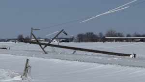
Northwest Iowa Power Cooperative Facebook page photo (3-20-25)
“In situations where we have crews coming in from outside of our service area, we are making sure that they are briefed on the situation, that they know where to go and what needs to be assessed and repaired, and then we’re making sure that they have adequate food and water resources and that they’ve also got a place to sleep,” Greenwood says.
He says crews from Illinois, Indiana, Kansas, Missouri, Michigan, Nebraska, and Wisconsin came to Iowa to help with this storm.
Today: Partly sunny & windy w/a slight chance of showers and thunderstorms after 5pm. A High near 56. S/SW winds at 15-35 mph this morning becoming W/NW this afternoon.
Tonight: Mostly cloudy w/a slight chance of showers and thunderstorms this evening. Gradually becoming mostly clear. Low around 25. NW winds 10-25 mph becoming light and variable after midnight.
Tomorrow: Increasing clouds. Breezy. A high near 60. S/SE winds becoming southerly @ 15-25 mph.
Tom. Night: Mo. cloudy & breezy w/a 20% chance of rain after midnight. Low around 38. S/SE winds 15-25 mph.
Sunday: Sunny & windy, with a high near 57.
Sunday Night: Mostly clear & windy, with a low around 29.
Monday: Mostly sunny, with a high near 57.
Thursday’s High in Atlantic was 49. The Low was 19. Last year on this date (3/21) the High in Atlantic was 44 & the Low was 23. The Record High was 80 in 1938. The Record Low was -7 in 1906. Sunrise: 7:24; Sunset: 7:32.
(Radio Iowa) – Iowans who parked outside during Wednesday’s heavy thunderstorms (and for that matter, storms that occurred the week before) are finding their vehicles now look like they’ve been dunked in mud. National Weather Service meteorologist Alexis Jimenez says those brown smudges and polka-dots have far-away origins, thanks to the winds of the massive storm, which topped off above 70 miles an hour.
“With it being so powerful, it pulls up a lot of air from the south,” Jimenez says, “and usually we think about moisture coming from the south, but also it brought in some of the dust and dirt from places like New Mexico and Texas all the way up into the Midwest.” There’s plenty of grit and sand in the gunk, too, which she says came from the deserts of the southwestern U-S. “Truly, it is just how powerful the winds were with that system,” Jimenez says. “The moisture in the air just moved this way from the south and that dirt just continued to get lofted higher up. And as you go higher up in the air, the winds get faster, so it can travel a lot farther, and then once the rain started to form, it’s sort of just taking all that dirt out of the sky.”
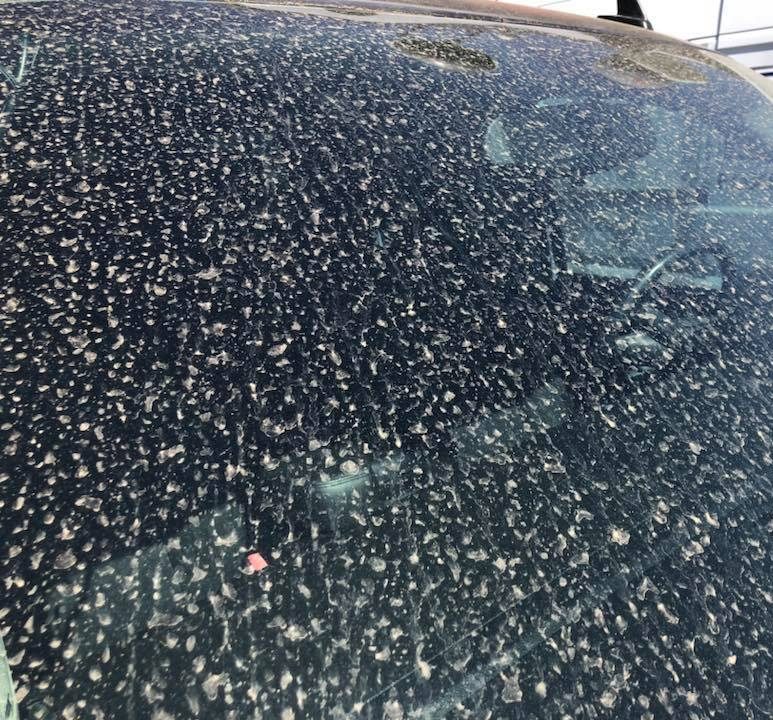
The effects of a “Mud rain”
With sunny skies and highs back in the 40s and 50s, Iowa car washes should likely brace for a business boost.
Today: Sunny, with a high near 46. Northwest wind 10 to 15 mph becoming west southwest this afternoon.
Tonight: Increasing clouds, with a low around 33. S/SW @ winds 10 to 20 mph, with gusts near 30 mph.
Tomorrow: Partly sunny & breezy w/a slight chance of rain late in the afternoon. A high near 55. S/SW winds 15-30 mph becoming N/NW in the afternoon.
Tom. Night: Mostly clear, with a low around 25. W/NW @ 10-25 becoming light after midnight.
Saturday: Mostly sunny & breezy, with a high near 60.
Sat. Night: Mostly cloudy & breezy w/a 40% chance of rain after midnight. A low around 39.
Sunday: A slight chance of rain, otherwise mostly sunny & windy, with a high near 55.
Wednesday’s High in Atlantic was 37. The Low was 19. We had received .2″ of sleet/ice Wednesday, in Atlantic (at KJAN), along with .3″ of snow. The total amount of precipitation (Rain/Sleet/Snow) had a liquid value of .13″. Last year on this date (3/20) the High in Atlantic was 66 & the Low was 30. The Record High was 79 in 1976. The Record Low was -14 in 1923. Sunrise: 7:26; Sunset: 7:31.


