
(Atlantic, Iowa) – March weather data for Atlantic (Compiled here at KJAN – the official National Weather Service reporting site), shows we were nearly 10-degrees warmer than the normal average for a monthly high, and right on target for the Low. Precipitation on the other hand, was significantly less than what we should expect.
Looking at the date: The Average High in Atlantic last month was 57. The Average Low was 26. Precipitation (Rain and/or melted snow), amounted to just 1.44-inches. Normally we would expect to realize 2.38-inches of combined precipitation. Total snowfall was 6.5-inches. Most of that fell March 4th. It didn’t stick around long, as highs quickly warmed from the mid-20’s into the upper 70’s.
Looking ahead, we find the High temperature for the month of April in Atlantic, is 62 degrees, while the average Low is 50. Precipitation typically amounts to 3.43-inches.
Check back with us during the first week of Mayl, 2025, to see how our actual weather data compared to the historical averages.
Today: Cloudy windy w/a 40% chance of showers, mainly later this afternoon. High near 55. SE winds 15-40 mph.
Tonight: Showers and thunderstorms. Low around 45. SE winds @ 20-40 mph decreasing after midnight. New rainfall amounts between a half and three quarters of an inch possible.
Tomorrow: A chance of showers and thunderstorms through mid-day; becoming mostly sunny. Windy. A high near 62. Winds S @ 15-25 in the morning becoming westerly in the afternoon, & gusting to around 30 mph. New precipitation amounts of less than a tenth of an inch, except higher amounts possible in thunderstorms.
Thursday: Partly sunny, with a high near 56.
Friday: A 30% chance of rain, mainly after 1pm. Mostly cloudy, with a high near 56.
Monday’s High in Atlantic was 54. Our Low this morning was 33. Last year on this date (4/1), the High in Atlantic was 60 and the Low was 37. The Record High on April 1st was 87 in 2012. The Record Low was 12 in 1924. Sunrise: 7:06; Sunset: 7:44.
(Radio Iowa) – After parts of Iowa saw near-record high temperatures in the 70s and 80s on Friday, the weekend wrapped up with snow in some areas on Sunday afternoon. Meteorologist Andrew Ansorge at the National Weather Service in Johnston, says snowfall amounts weren’t deep. “We saw a two-inch report over towards Fort Dodge,” Ansorge says, “and down here in Des Moines, we had a third of an inch at the airport.” He suggests Iowans keep a close eye on the forecast.
“We’re looking at another round of storms moving through the state Tuesday night into Wednesday,” Ansorge says, “and with that, the chance for large hail and damaging wind gusts.” 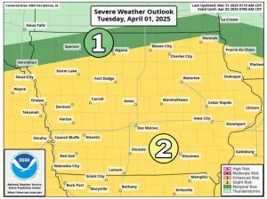
The forecast calls for partly sunny skies Thursday and Friday with the possibility of rain returning on Saturday.
Today: Mostly sunny, with a high near 51. North winds 5 to 10 mph.
Tonight: Increasing clouds. A low around 33. NE winds becoming E/SE @ 5-15, w/gusts to near 20 mph.
Tomorrow: A 40% chance of rain. High near 56. SE winds 15-30 mph gusting to near 40.
Tom. Night: Rain and possibly a thunderstorm. Low around 45. Winds SE @ 15-35 mph.
Wednesday: A chance of rain or thunderstorms through mid-day; Becoming mostly sunny & windy. High 62.
Wednesday Night: Mostly clear & breezy, with a low around 31.
Thursday: Partly sunny, with a high near 55.
Sunday’s High in Atlantic was 39. Our Low this morning was 33. Last year on this date (3/31), the High in Atlantic was 57 and the Low was 34. The Record High on March 31st was 87 in 1968. The Record Low was 8 in 1964. Sunrise: 7:07; Sunset: 7:43.
Today: Cloudy & breezy w/a slight chance of rain showers, mixing with snow after 2pm, then gradually ending. A high near 40. Winds NW @ 15-30 mph.
Tonight: Mostly cloudy & blustery, with a low around 29. N/NW winds 10-25 mph.
Tomorrow: Mostly sunny, with a high near 51. North wind 5 to 10 mph.
Tuesday: Cloudy & windy w/a 50% chance of rain. High near 55.
Wednesday: Partly sunny & windy w/a 40% chance of rain and thunderstorms. High near 63.
Thursday: Mostly sunny, with a high near 57.
Saturday’s High in Atlantic was 64. Our Low this morning (as of 5:30-a.m.) was 36. We had received .12″ rain at KJAN since 7-a.m. Saturday. Last year on this date (3/30), the High in Atlantic was 68 and the Low was 34. The Record High on March 30th was 90 in 1986. The Record Low was 5 in 1969. Sunrise: 7:09; Sunset: 7:42.
Today: Cloudy with 60% chance of showers & possible thunderstorms. A high near 67. S/SE winds 9-14 mph with gusts as high as 22. New rainfall amounts of less than a tenth of an inch, except higher amounts possible in thunderstorms.
Tonight: Showers & possible thunderstorms. Low around 37. E/SE Winds becoming W/NW @ 9-14. New rainfall amounts between a quarter and half of an inch are possible.
Sunday: Cloudy & breezy w/a 40% chance of showers. Steady temperature around 39. N/NW winds 15-20 mph with gusts as high as 28.
Sun. Night: Mostly cloudy & blustery, with a low around 29.
Monday: Mostly sunny, with a high near 50.
Tuesday: Mo. cloudy & windy w/a 50% chance of rain. A high near 58.
Friday’s High in Atlantic was 79. The Low was 55. Last year on this date (3/29), the High in Atlantic was 65 and the Low was 21. The Record High on March 29th was 84 in 1910 & 1986. The Record Low was 11 in 1898. Sunrise: 7:10; Sunset: 7:40.
(Radio Iowa) – Severe Weather Awareness Week is wrapping up with a reminder on how to stay safe during flooding. National Weather Service meteorologist Peter Rogers says flood deaths can be avoided.
Rogers says it does not take much water to carry a car or truck off a roadway.

Radio Iowa file photo
He says there are two types of flooding.
Rogers says flooding is another reason they advise you to make up an emergency kit that you have ready to go if you are suddenly forced out of your home.
(Radio Iowa) – This is Severe Weather Awareness Week, and National Weather Service meteorologist Peter Rogers says it is important to know what is happening when a thunderstorm warning is issued. Rogers says there are a couple of factors that go into those warnings. “Hail that is the size of a quarter or larger, which is about the diameter of a quarter. And wind gusts that are at 58 miles an hour or higher,” he says. He says the speed of the wind is key.
“That’s generally when you start to see branches about the size of your wrist starting to break off. And obviously, the stronger the wind, the more potential damage and destruction you can see,” Rogers says. “On the hail side, an inch in diameter, that is when you start to see potential impacts to roofing material or you vehicle being dented. Those are king of those baselines when we start to issue thunderstorm warnings.” Rogers says straight line winds, including derechos, have become more common in the Midwest. “In our eyes at the Weather Service, whether the wind is spinning or moving in a straight line, if it is strong enough to start breaking things we want people to be paying attention, ” he says.

File photo from the July, 2024 derecho that toppled an 80,000-bushel grain bin in Luxemburg, Iowa (Photo by Luxemburg Fire Dep’t)
And take the same proactive action, again with regards to whether it is a tornado or not.” Rogers says its important to heed the warnings for thunderstorms and be prepared to react.
Near-record high temperatures and breezy winds from the southwest gusting 30 to 40 mph will produce elevated fire weather conditions today. Burning is discouraged.
Today: Sunny & windy. A high near 83. S/SW winds 15-40 mph.
Tonight: Partly cloudy to cloudy & windy w/a 30% chance of showers & thunderstorms after midnight. Low around 53. S/SW winds 15-30, decreasing after midnight to around 10-15 mph. New rainfall amounts of less than a tenth of an inch, except higher amounts possible in thunderstorms.
Tomorrow: An 80% chance of showers & thunderstorms. High near 64. SE winds 10-25 mph. New rainfall amounts between a tenth and quarter of an inch, except higher amounts possible in thunderstorms.
Tom. Night: Showers & thunderstorms likely. Low around 36. New rainfall amounts between a quarter and half of an inch possible.
Sunday: A 50% chance of showers & thunderstorms. Breezy. A high near 46.
Monday: Mostly sunny, with a high near 49.
Tuesday: Mostly cloudy & windy w/a 40% chance of rain. A high near 53.
Thursday’s High in Atlantic was 71. The Low was 50. Last year on this date (3/27) the High in Atlantic was 38 & the Low was 19. The Record High was 85 in 1895. The Record Low was 6 in 1894. Sunrise: 7:11; Sunset: 7:39.
Today: A 30% chance of showers, otherwise mostly sunny. A high near 74. Winds S @ 10-20 mph.
Tonight: A 30% chance of showers and thunderstorms; Partly cloudy. Low around 56. E/SE winds @ 10-30 mph.
Tomorrow: Sunny & windy. High near 81. S/SW winds @ 15-35 mph.
Tom. Night: A slight chance of showers & thunderstorms. Low around 52. S/SW @ 15-30 mph. .
Saturday: A chance of showers & thunderstorms.High near 64.
Sat. Night: Showers likely and possibly a thunderstorm. Low around 34.
Sunday: A 50% chance of rain. Breezy High near 44.
Monday: Partly sunny, with a high near 48.
Wednesday’s High in Atlantic was 65. The Low was 22. We received .32″ rain this morning, in Atlantic (As of 7-a.m./24-hour total). Last year on this date (3/27) the High in Atlantic was 30 & the Low was 19. The Record High was 88 in 1907. The Record Low was -2 in 1955. Sunrise: 7:13; Sunset: 7:39.


