
Today: Sunny & breezy, with a high near 74. Winds South @ 10-20 mph w/gusts to around 30.
Tonight: Partly cloudy w/a slight chance of showers & thunderstorms after midnight. Low around 55.
Tomorrow: A 30% chance of showers & thunderstorms, otherwise partly sunny & breezy. High near 79. Winds S @ 15-30.
Tom. Night: P/Cldy w/a 50% chance of showers & thunderstorms. Low around 47. New rainfall amounts between a tenth and quarter of an inch, except higher amounts possible in thunderstorms.
Friday: Mostly cloudy & breezy w/a slight chance of showers. High near 59.
Friday Night: Mostly cloudy, with a low around 37.
Saturday: Mostly sunny, with a high near 59.
Saturday Night: Partly cloudy, with a low around 38.
Sunday: Partly sunny & breezy w/a 50% chance of showers. A high near 56.
Tuesday’s High in Atlantic was 64. Our Low this morning was 29. Last year on April 16th, the High in Atlantic was 75 and the Low was 50. The Record High was 88 in 1898. The Record Low was 19 in 1988. Sunrise: 6:39; Sunset: 8:01.
Today: Sunny & breezy with a high near 61. Winds NW @ 10-15 w/gusts to near 25 mph.
Tonight: Clear, with a low around 36. Northwest wind 5 to 10 mph becoming calm.
Tomorrow: Mostly sunny & breezy. A high near 72. Winds S @ 15-25.
Tom. Night: A slight chance of showers & thunderstorms, otherwise partly cloudy & breezy. Low around 52.
Thursday: A 50% chance of showers & thunderstorms, otherwise partly sunny & breezy. High near 80.
Thursday Night: A 40% chance of showers & thunderstorms. Low around 50.
Friday: Partly sunny & breezy, with a high near 64.
Monday’s High in Atlantic was 60. The Low was 35. Last year on April 15th, the High in Atlantic was 81 and the Low was 49. The Record High was 84 in 1920. The Record Low was 17 in 1926 & 1962. Sunrise: 6:40; Sunset: 8:00.
Today: Partly sunny & windy. A high near 58. NW winds 20-35 mph.
Tonight: Mostly clear & windy. A low around 35. NW @ 15-35 mph.
Tomorrow: Sunny & breezy. A high near 61. NW @ 10-30 mph.
Tom. Night: Mostly clear, with a low around 36.
Wednesday: Mostly sunny & breezy. A high near 71.
Wed. Night: P/Cldy & breezy w/a slight chance of showers & thunderstorms late. Low around 50.
Thursday: P/Sunny & breezy w/a 40% chance of showers & thunderstorms. A high near 78.
Sunday’s High in Atlantic was 82. The Low was 46. Last year on April 14th, the High in Atlantic was 88 and the Low was 49. The Record High was 89 in 2003. The Record Low was 11 in 1907. Sunrise: 6:42; Sunset: 7:59.
Today: Partly sunny & breezy. High near 80. South winds 10-15 mph becoming NW this afternoon & gusting to 25 mph.
Tonight: Mostly cloudy & windy. Low around 43. Winds NW 15-to near 40 mph.
Tomorrow: Mostly cloudy early, then gradually becoming sunny. High 60. NW @ 25-40 mph.
Tom. Night: Mostly clear & windy. Low around 35. NW winds 15-35 mph.
Tuesday: Sunny & breezy, with a high near 62.
Tuesday Night: Mostly clear, with a low around 38.
Wednesday: A 20% chance of showers, otherwise mostly sunny & breezy, with a high near 69.
Saturday’s High in Atlantic was 74. The Low was 43. Last year on April 13th, the High in Atlantic was 84 and the Low was 44. The Record High was 88 in 2006. The Record Low was 11 in 1950. Sunrise: 6:44; Sunset: 7:58.
Today: Mostly sunny, with a high near 73. South wind 9 to 14 mph increasing to 20 to 25 in the afternoon with gust as high as 34.
Tonight: Partly cloudy, with a low around 53. Breezy, with south winds @ 15-18 with gust as high as 28.
Tomorrow: Partly sunny & windy, with a high near 80. South winds 10-20 becoming northwest in the afternoon with gusts to near 26 mph.
Tom. Night: Mostly cloudy & windy, with a low around 44. Northwest 17-22 mph, gust as high as 34.
Monday: Mostly sunny & windy, with a high near 59. Northwest wind 21 to 26 mph, gust as high as 34.
Monday Night: Mostly clear & windy, with a low around 36.
Tuesday: Sunny with a high near 62.
Tuesday Night: Mostly clear, with a low around 39.
Wednesday: 30% chance of showers after 1pm. Partly Sunny, with a high near 71 and breezy.
Friday’s High in Atlantic was 64. The Low was 32. Last year on April 12th, the High in Atlantic was 67 and the Low was 32. The Record High was 86 in 1916. The Record Low was 13 in 1957. Sunrise: 6:45; Sunset: 7:57.
(Radio Iowa) – The latest Drought Monitor report shows improvement in most areas of the state thanks to above-normal precipitation in March. The D-N-R’s Jessica Reese McIntyre says western, and central and northwest Iowa got he most rain. She says northwest Iowa in particular had areas of severe drought. “That was completely removed with the rain that fell, the precipitation that northwest Iowa saw, and so that’s very encouraging,” she say. Mcintyre says there wasn’t much change in the southeast and southwest areas of the state. “They are just kind of floating along. There was a little bit of improvement in southwest Iowa, but for the most part, they are kind of holding to where they were,” McIntyre says.
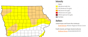
Iowa Drought Monitor map (released 4-10-25)
The eastern side of the state has the largest area of drought. “Unfortunately, northeast Iowa did not see a whole lot of improvement. They’re still in the d1 classification, which is moderate drought,” McIntyre says. McIntyre says the overall picture is pretty good right now. “We are in a significantly better position than we were this time last year, as far as drought is concerned, because we didn’t bust out of that really long record drought until the end of May, early June,” she says.
McIntyre says we are getting into our wettest months and if that holds true this year, we could see more of the dry conditions go away.
Today: Sunny, with a high near 61. North wind 5 to 20 mph.
Tonight: Mostly clear, with a low around 39. Winds S/SE @ 5-10.
Tomorrow: Mostly sunny & windy, with a high near 72. Winds S @ 10-20 w/afternoon gusts to near 35 mph.
Tom. Night: Mostly cloudy & breezy, with a low around 54. Winds S @ 15-30 mph.
Sunday: Partly sunny, with a high near 78.
Sunday Night: Mostly cloudy & breezy, with a low around 45.
Monday: Mostly sunny & windy, with a high near 59.
Monday Night: Mostly clear & breezy, with a low around 35.
Tuesday: Sunny, with a high near 62.
Today: A slight chance of showers or sprinkles, otherwise mostly sunny & windy, with a high near 64. N/NW winds 10-20 w/gusts to near 35 mph.
Tonight: Partly cloudy & breezy, with a low around 36. Winds N @ 15-30 decreasing to around 5-10 mph overnight.
Tomorrow: Sunny, with a high near 63. North wind 5 to 10 mph.
Tom. Night: Mostly clear, with a low around 38.
Saturday: Mostly sunny & windy, with a high near 71.
Sunday: Partly sunny, with a high near 79.
Monday: Mostly sunny & windy, with a high near 61.
Wednesday’s High in Atlantic was 74. The Low was 33. Last year on this date (4/10) the High in Atlantic was 74, and the Low was 30. The Record High on this date was 94 in 1930. The Record Low was 17 in 1989. Sunrise: 6:48; Sunset: 7:54.
Today: A slight (10%) chance of showers or sprinkles this morning, otherwise mostly sunny & breezy, with a high near 70. South winds becoming N/NW @ 10-25 mph.
Tonight: Mostly clear, with a low around 41. West wind 5 to 10 mph.
Tomorrow: A 20% chance of showers before 3pm, otherwise mostly sunny & windy. A high near 63. NW winds 10-20 mph gusting to near 30 in the afternoon.
Tom. Night: Partly cloudy & breezy. Low around 37. Winds N @ 10-25 mph will be decreasing after midnight.
Friday: Sunny, with a high near 62.
Friday Night: Mostly clear, with a low around 38.
Saturday: Sunny & windy, with a high near 70.
Tuesday’s High in Atlantic was 57. The Low was 18. Last year on this date (4/9) the High in Atlantic was 67, and the Low was 30. The Record High on this date was 85 in 1977. The Record Low was 14 in 2016. Sunrise: 6:50; Sunset: 7:53.
Today: Sunny, with a high near 57. S/SE winds 10-20 mph.
Tonight: Mostly cloudy w/a slight chance of showers after midnight. Low around 41. S/SE @ 10-20 mph.
Tomorrow: Partly sunny & breezy w/a slight chance of showers early. High near 68. S-N/NW @ 5-15 mph gusting to around 20 mph.
Tom. Night: Partly cloudy, with a low around 42.
Thursday: Mostly sunny & windy, w/a slight chance of showers after 1pm. A high near 64.
Thursday Night: Partly cloudy, with a low around 35.
Friday: Sunny, with a high near 62.
Monday’s High in Atlantic was 47. The Low was 18. Last year on this date (4/8) the High in Atlantic was 65, and the Low was 34. The Record High on this date was 89 in 1931. The Record Low was 14 in 2016. Sunrise: 6:52; Sunset: 7:52.


