
Atlantic (KJAN), .2”
Atlantic (7.1 miles N/NE), .17″
Elk Horn, .21”
Anita, Audubon, & Cumberland, .3” each
Clarinda & Corning, 35”
Creston & Guthrie Center, .5”
Cromwell (Union County), .29”
Emerson & Oakland, .2”
Greenfield, .4”
Griswold & Red Oak, .25”
Harlan,.31”
Massena, .16”
Missouri Valley, .26”
Shenandoah, .15”
Wiota,.32”
Today: Partly sunny to sunny. A high near 69. West winds 10-20 becoming south southwest in the afternoon.
Tonight: A 40% chance of showers & thunderstorms after midnight. Low around 49. S/SE @ 10-20 mph.
Tomorrow: A 30% chance of showers & thunderstorms, otherwise partly sunny. A high near 75. S @10-20 mph. o
Tom. Night: A slight chance of showers after midnight, otherwise mostly clear, with a low around 48.
Wednesday: Partly sunny w/a 50% chance of showers & thunderstorms after 1pm. A high near 74.
Wednesday Night: Showers likely and possibly a thunderstorm. Low around 53.
Thursday: Showers and possibly a thunderstorm. High near 72.
Sunday’s High in Atlantic was 49 and the Low was 43. We received .2″ (two-tenths) of an inch of rain, Sunday. Last year on April 21st, the High in Atlantic was 62 and the Low was 26. The Record High was 88 in 1980. The Record Low was 16 in 1907. Sunrise: 6:31; Sunset: 8:07.
(Omaha, NE) – The National Weather Service has revised an earlier statement, with regard to what was initially described as a record-breaking wide tornado that occurred Thursday evening in parts of Fremont and Page Counties. Officials said two powerful, long-lived supercells tracked across eastern Nebraska and southwest Iowa during the afternoon and evening hours
of April 17. The storms produced widespread damaging hail up to 4 inches in diameter, wind gusts greater than 80 mph, and multiple tornadoes.
Their latest report said “Approximately 8:13 pm on Thursday, April 17, 2025, a tornado formed 3 miles southwest of Tabor. The tornado stirred up copious amounts of dust and dirt from recently plowed agricultural field. The tornado moved southeast across mainly agricultural fields until cross U.S. 275, producing EF-0 damage to roofs and farm outbuildings just south of 130th Street, reaching a width of about 1/4 mile. Based on video, the tornado weakened briefly east of U.S. 275 until it crossed 280th Avenue, where it again reached a width of about 1/4 mile and strengthened again before crossing
290th Avenue, producing EF-0 damage to trees and flipping irrigation pivots. The tornado continued until about the intersection of 300th Avenue and 140th Street where it dissipated.”
With regard to the Fremont-Page County tornado, the Weather Service said that “At approximately 8:32 PM CDT, a tornado formed southeast of Randolph, IA. The first sign of damage was snapped tree limbs near Lake Shawtee WMA (Wildlife Management Area). As the tornado progressed eastward, continued tree damage was observed along with the damage of small outdoor farm buildings and house roofs. A concentrated area of the most extensive damage was observed south of Imogene, IA. 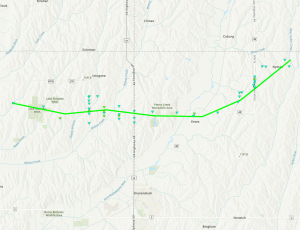

Destroyed outbuilding just north of Essex, west of D Ave.
NWS Damage Survey photo
In this area, damage included snapped wooden power poles, minor damage to homes, and the continued damage of outdoor buildings and trees. The width of damage also reached its peak, approximately 1,971 yards (a little more than 1.1.miles) in this area. The tornado tracked just north of Essex, IA, with more wooden power poles snapped and farm outdoor building damage. After sliding north of Essex, IA, the tornado tracked northeast towards Nyman, IA. Similar damage, including trees, outdoor buildings, and wooden power poles were observed along this stretch. The tornado lifted just east at Nyman, IA at approximately 9:08 PM CDT.
Their previous statement said the tornado near Essex Thursday night was rated as an EF-1, with estimated peak winds of as much as 110 mph, with a maximum width at its peak, of 3,130.6 yards (1.78 miles) (which would have broken a record set in 1950). It was on the ground for nearly 20-miles (19.72).
The track of the twister, its rating and time on the ground did not change in the latest assessment.
Today: Showers, w/widespread heavy rainfall. Breezy. A High near 49. E/NE winds 10-20 w/gusts to near 3o mph. New precipitation amounts between three quarters and one inch possible.
Tonight: Showers & possible thunderstorms. Breezy. Low around 41. N/NW winds 15-30 mph becoming W/NW after midnight. New precipitation amounts between a quarter and half of an inch possible.
Tomorrow: Cloudy through mid morning, then gradual clearing, with a high near 66. W/NW winds @ 10-20 mph.
Tom. Night: A chance of showers & thunderstorms. Low around 48.
Tuesday: A 40% chance of showers & thunderstorms. High near 74. S-W winds 10-20 mph.
Tuesday Night: Mostly clear, with a low around 47.
Wednesday: A 40% chance of showers, mainly after 1pm. High near 73.
Saturday’s High in Atlantic was 59 and the Low was 36. Last year on April 20th, the High in Atlantic was 52 and the Low was 26. The Record High was 90 in 1902. The Record Low was 18 in 1956. Sunrise: 6:33; Sunset: 8:05.
Today: Mostly cloudy, then gradually becoming sunny, with a high near 58. North northeast wind 5 to 15mph.
Tonight: Increasing clouds, with a low around 39. East northeast wind 5 to 10 mph.
Tomorrow: Cloudy & breezy w/rain, mainly after 8-a.m. High near 51. Winds E @ 10-20 mph w/gusts to around 25. New precipitation amounts between a half and three quarters of an inch possible.
Tom. Night: Showers and possibly a thunderstorm. Low around 40. NE winds 15-25 shifting to the NW after midnight. New precipitation amounts between a quarter and half of an inch possible.
Monday: Mostly sunny & breezy, with a high near 66. W/NW winds 10-20 mph.
Tuesday: A chance of showers & afternoon thunderstorms, otherwise mostly sunny, with a high near 74.
Friday’s High in Atlantic was 55 and the Low was 37. We received a Trace of rain in the form of drizzle/mist. Last year on April 19th, the High in Atlantic was 57 and the Low was 29. The Record High was 87 in 1908, 1946 & 1987. The Record Low was 15 in 1988. Sunrise: 6:34; Sunset: 8:04.
(Radio Iowa) – Damage is being assessed in southwest Iowa’s Page and Fremont counties after a tornado touched down Thursday night. Page County emergency management coordinator Jill Harvey says the storm veered north of the town of Essex. “Thankfully, it did not hit directly in Essex,” Harvey says. “They had some minor power outages here in town, but there are several structures damaged around the area.” Harvey says officials were concerned for a time that the tornado would strike Shenandoah, but fortunately, it steered away. She’s asking Essex residents to avoid leaving their homes, for now, and for gawkers to keep out.
“We do have quite a few trees covering roads,” Harvey says. “You may come across roads that are blocked. Due to the damage and debris across roads and downed power lines, we are requesting that people stay out of the area. If you happen to be around Essex, please use extreme caution. There are power lines down.” Despite the damage, Harvey says no injuries were reported in the county. National Weather Service survey teams are expected to fan out across the region to inspect the damage. Iowa Agriculture Secretary Mike Naig says he expects the farming community to take a heavy hit from the storms. “While some towns may have been sparred, like Essex,” Naig says, “everybody was really watching last night, and hoping for the best there. We know that there have been farms that have been damaged.”
Aside from the tornado damage, Naig says reports of large hail in parts of the state are also concerning. “Just incredible hail size and hail damage,” Naig says. “Not just in southwest Iowa, but we did see some reports even up in northeast (Iowa), where there were some systems that got built up, and you’re hearing about one inch and two inch hail sizes — and that can do a heck of a lot of damage, as we all well know.” Thursday’s storms struck in the wake of last year’s horrific tornado outbreaks, including the May 21st twister that hit Greenfield. Though rebuilding efforts continue in Greenfield, Naig says some producers are still coping with storm damage.”There’s been an incredible amount of work that’s been done,” Naig says. “A lot of homes rebuilt, some farm places that are on their way, but a lot of people that are not yet in their homes. It’s a year ago that it happened. It’s a good reminder that, hey, there’s been a ton of progress made, with the community rallying together — the communities, not just Greenfield. But, boy, we’re a long ways from being totally recovered.”
Naig says it’s “just the reality, unfortunately, of spring, particularly in Iowa.”
Atlantic (KJAN), 1.14”
Atlantic, 7.1 miles N/NE, .28”
Adair, .55”
Anita, 1.1”
Audubon, .4”
Creston, .61”
Elk Horn, .1”
Glenwood, 1.2″
Greenfield, 1.35”
Guthrie Center, .6”
Harlan, .4” ; KNOD in Harlan reported just. .05″
Kirkman, .04″
Manning, .01″
Massena, .04-to .05″ (2 reports)
Missouri Valley, .07-to .15″ (2 reports)
Oakland. .5”
Pacific Junction, .42″
Persia, .29″
Red Oak, .74”
Today: Mostly cloudy, then gradually becoming sunny, with a high near 58. North northeast wind 8 to 13 mph
Tonight: Increasing clouds, with a low around 39. East northeast wind 5 to 9 mph.
Tomorrow: Showers, mainly after 8am. High near 51. Chance of precipitation is 90%. New precipitation amounts between a half and three quarters of an inch possible.
Tom. Night: Showers and possibly a thunderstorm. Low around 40. Breezy. New precipitation amounts between a quarter and half of an inch possible.
Monday: Mostly sunny, with a high near 66. West northwest wind around 11 mph, with gusts as high as 20 mph.
Mon. Night: A 30 percent chance of showers after 1am. Mostly clear, with a low around 48. New precipitation amounts of less than a tenth of an inch possible.
Tuesday: A chance of showers, with thunderstorms also possible after 1pm. Mostly sunny, with a high near 74. Chance of precipitation is 40%.
Wednesday: A 40 percent chance of showers. Mostly sunny, with a high near 73.
Thursday’s High in Atlantic was 77. The Low was 47. We received 1.14″ of rain Thursday night. Last year on April 18th, the High in Atlantic was 57 and the Low was 28. The Record High was 89 in 1948. The Record Low was 17 in 1985. Sunrise: 6:36; Sunset: 8:03.
(Reports relayed to the National Weather Service offices in Omaha/Valley, NE, & in Des Moines):
10:58-p.m. Quarter-size hail fell near Thayer, in Union County.
10:49-p.m. Dime-to-quarter size hail fell in Afton (Union County).
10:22-p.m. Thunderstorm wind damage 3 miles SE of Kent in Union County. Damage to farm buildings, trees & power lines. 6 power poles broken in the area.
10:21-p.m. 5 miles E. of Lenox (Taylor County): Thunderstorm winds estimated at 76 mph; lots of blowing dust (Trained spotter report)
10:8-p.m. Thunderstorm winds gusted up to 61 mph on the north side of Lenox.
9:53-p.m. 1 inch (diameter) hail in Corning (Adams County) – – Trained spotter report
9:49-p.m. 1 inch hail 4 miles W/SW of Corning – Spotter report
9:04-p.m. A personal weather station 5 miles SE of Coburg (Page County) registered a wind gust of 86 mph.
8:50-p.m. 3 miles W/NW of Essex (Page County): Golfball to Baseball-size hail (2.75″ diameter) reported by Emergency Management
8:48-p.m. 4 miles W. of Essex: Power poles snapped, trees and shed material strewn over roadway.
8:50-p.m. 3 miles W/NW of Essex (Page County): Tornado reported at Pierce Creek Recreation Area. (Emg. Mgmt); Golfball to baseball-size hail reported 3 miles W/NW of Essex.
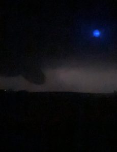
Funnel cloud near Lyman at around 8:35-p.m. (Photo courtesy Zach Ploen)
8:32-p.m. 6 miles E/SE of Oakland (Pott. County): Possible report of a tornado between Griswold and Oakland, from trained spotter.
8:27-p.m. 5 miles SW of Randolph (Fremont County): Tornado confirmed by video feed
8:22-p.m. Lewis, IA Quarter-sized hail (1″ dia) reported by Fire/Rescue personnel
8:21-p.m. 3 miles S. of Tabor (Fremont County): Storm chaser reported a tornado
8:16-p.m. 4 miles N. of Thurman (Fremont Co.): golf-ball size hail (1.75″) observed by a trained storm spotter
7:44-p.m. 2 miles NW of McClelland (Pott. County): reports of hail estimated at 4-inches in diameter (softball size)


