
DUBUQUE, Iowa (AP) — Much of Iowa and Nebraska are bracing for another wintry blast overnight into the weekend, with parts of eastern Iowa already under a winter storm warning. The National Weather Service says a winter storm is expected to drop as much as 8 inches of snow in east-central Iowa, including the cities of Dubuque, Cedar Rapids, Iowa City, Muscatine and Davenport. The weather service says snow will start falling by late Thursday afternoon, continuing throughout the day Friday. Most of Iowa is under a winter weather advisory, where 2 to 5 inches of snow is expected.
The weather service has placed most of Nebraska under a hazardous weather outlook for Thursday night into Friday, with 1 to 3 inches of snow expected, as the storm system moves southeast across the state.
Today: P/Cloudy to Cldy w/scattered flurries. High 28. S-N @ 10.
Tonight: Cloudy w/light snow. Low 18. N @ 5-10.
Tomorrow: Cloudy w/light snow, mainly in the morning (1-2” total). High 18. N @ 10-15.
Saturday: Cloudy w/light snow. High 16.
Sunday: P/Cldy. High 25.
Wednesday’s High in Atlantic was 18. Our 24-hour Low was 4. Last year on this date our High was 18 and the Low was 3. The record High in Atlantic on this date was 62 in 1954, and the Low was -34 in 1971.
A Winter Weather Advisory is in effect from 9-p.m. (tonight, 2/8) until 9-a.m. Friday, for the following area Counties in the KJAN listening area: Guthrie-Dallas-Carroll and Crawford.
Snow is expected to redevelop across much of northern Iowa this afternoon and spread slowly southward into central Iowa Thursday night and early Friday morning. In addition, northeast winds will increase late tonight into early Friday morning with
patchy blowing and drifting snow expected, especially in rural, open areas.
Total snow accumulations of 1 to 4 inches are expected.
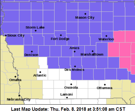
Winter Weather Advisory for counties shaded in purple.
Plan on slippery road conditions, including during the morning commute on Friday. Be prepared for reduced visibilities at times.
The National Weather Service has issued a Winter Weather Advisory for parts of the KJAN listening area, effective from 9-p.m. Thursday to 9-a.m. Friday. The Advisory includes Crawford-Carroll-and Dallas Counties in our area. –
Total snow accumulations of 2 to 5 inches are expected.
Plan on slippery road conditions including during the Friday morning commute. Be prepared for reduced visibilities and hazardous travel conditions at times. Take it
slow in the snow!.
A Winter Weather Advisory for snow means periods of snow will cause primarily travel difficulties. Be prepared for snow covered roads and limited visibilities, and use caution while driving. The latest road conditions for the state you are calling from can
be obtained by calling 5 1 1.
Today: P/Cloudy. High 20. W/NW @ 10-15.
Tonight: Cloudy. Low 8. V @ 5-10.
Tomorrow: Mo. Cloudy w/flurries. High 28. SE @ 10-15.
Friday: Cloudy w/snow, especially in the morning. High 22.
Saturday: Mo. Cloudy w/light snow. High 18.
Tuesday’s High in Atlantic was 10. We received .1” snow yesterday. Our 24-hour Low (ending at 7-a.m. Today) will be/was -13 (at 5:30 it was 7 degrees). Last year on this date our High was 34 and the Low was 13. The record High in Atlantic on this date was 64 in 1987, and the Low was -30 in 1905.
Adams-Union-Taylor-Ringgold
...WINTER WEATHER ADVISORY IN EFFECT UNTIL MIDNIGHT CST TONIGHT...

* WHAT...Snow expected. Total snow accumulations of 1 to 3 inches
  are expected with highest accumulations near the Missouri border.
* WHERE...Far Southern Iowa.
* WHEN...Until midnight CST tonight.
* ADDITIONAL DETAILS...Plan on slippery road conditions. Be
  prepared for reduced visibilities at times.

PRECAUTIONARY/PREPAREDNESS ACTIONS...
A Winter Weather Advisory for snow means periods of snow will
cause primarily travel difficulties. Be prepared for snow covered
roads and limited visibilities, and use caution while driving.
The latest road conditions for the state you are calling from can
be obtained by calling 5 1 1.
Pottawattamie-Mills-Montgomery-Fremont-Page
...WINTER WEATHER ADVISORY IN EFFECT UNTIL 9 PM CST THIS
EVENING...

* WHAT...Snow expected. Total snow accumulations of 1 to 3
  inches are expected.
* WHERE...Portions of east central and southeast Nebraska and
  southwest Iowa.
* WHEN...Until 9 PM CST this evening.
* ADDITIONAL DETAILS...Plan on slippery road conditions,
  including during the evening commute. Be prepared for reduced
  visibilities at times.
The National Weather Service is offering free, Storm Spotter Training classes in the KJAN listening area. They are open to the public. Each training class is an hour and a half. Participants from neighboring counties are encouraged to attend.
 Classes will be held as follows:
Additional information and Storm Spotter Resources are available at: http://www.weather.gov/dmx/ stormspotting (A Calendar is in the Spotter Training tab at the bottom of the page).
The National Weather Service says another round of snow looks to develop late this afternoon over western Iowa and will transition east during the evening hours. Generally 1 to 2 inches of light snow is anticipated along and south of Interstate 80 to the Missouri border, with a few locations possibly receiving nearly 3 inches over the far south. This snow will impact the evening commute over much of central Iowa. Even though it’s only 1 to 2 inches, it’ll be enough to cover the roads and cause them to be very slick.
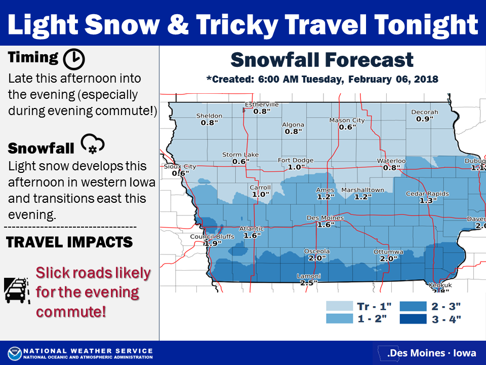 Motorists are asked to “Please, take it slow in the snow!!!” Additional light snow is forecast Thursday evening into Friday morning with even another round of snow possible on Saturday.
Today: P/Cloudy to Cldy w/snow developing this afternoon. High 13. SE @ 10.
Tonight: Light snow. (1-2” new accum. Possible) Low 8. V @ 5-10.
Tomorrow: P/Cloudy. High 20. W @ 5-10.
Thursday: Mo. Cloudy. High 28.
Friday: Mo. Cloudy w/light snow. High 23.
Monday’s High in Atlantic was 15. Our Low this morning was -13. We received 3 inches of snow Monday, which melted into .53″ liquid value. Last year on this date our High was 48 and the Low was 30. The record High in Atlantic on this date was 54 in 1966, and the Low was -27 in 1982.


