
Today: Areas of fog possible this morning; P/Cldy to Cldy. High 42. N @ 10-15.
Tonight: P/Cldy. Low 10. N @ 15-25.
Tomorrow: P/Cloudy. High 28. NW @ 10-15.
Saturday: Mo. Cldy. High 38.
Sunday: P/Cloudy. High near 48.
Wednesday’s High in Atlantic was 44. Our Low was 32. Last year on this date our High was 47 and the Low was 25. The record High in Atlantic on this date was 72 in 1921, the Low was -31 in 1905.
Today: Areas of fog possible this moring; Partly cloudy. High 45. SW @ 10-20.
Tonight: P/Cldy. Low 30. S @ 5-10.
Tomorrow: Mostly Cloudy. High 42. N @ 10-15.
Friday: P/Cldy. High 28.
Saturday: Cloudy. High near 40.
Tuesday’s High in Atlantic was 38. Our Low was 15. Last year on this date our High was 49 and the Low was 25. The record High in Atlantic on this date was 68 in 1934, the Low was -20 in 1936.
Today: Partly cloudy to cloudy. High around 33. S @ 10-15.
Tonight: P/Cldy. Low 25. S @ 5-10.
Tomorrow: P/Cldy. High 45. SW @ 10-20.
Thursday: Mostly cloudy w/a chance of light rain. High 40.
Friday: Cloudy. High 29.
Monday’s High in Atlantic was 19. (Temps rose overnight and by 5-a.m. today it was 20 degrees). Our Low was 1. Last year on this date our High was 49 and the Low was 23. The record High in Atlantic on this date was 63 in 1934, the Low was -30 in 1905.
Today: Partly cloudy. High around 21. NE @ 5-10.
Tonight: P/Cldy. Low 10. SE @ 5-10.
Tomorrow: P/Cldy. High 33. S @ 10-15.
Wednesday: P/Cldy. High 45.
Thursday: Cloudy w/a chance of light rain or snow. High 38.
Sunday’s High in Atlantic was 22. Our Low this morning (as of 5-a.m.) was -2. Last year on this date our High was 47 and the Low was 21. The record High in Atlantic on this date was 72 in 1990, the Low was -24 in 1986 & 1988.
Today: Cloudy through mid morning, then gradual clearing, with a high near 23. Wind chill values as low as -10. West wind 5 to 10 mph.
Tonight: Mostly clear, with a low around 1. Wind chill values as low as -10. Calm wind becoming east northeast around 6 mph after midnight.
Monday: Mostly sunny, with a high near 19. Wind chill values as low as -10. East wind 6 to 10 mph.
Tuesday: Partly sunny, with a high near 33. South southwest wind 7 to 13 mph.
Wednesday: Sunny, with a high near 40.
Thursday: Partly sunny, with a high near 34.
Saturday’s High in Atlantic was 11. Our Low this morning was 1. We received six-tenths (.6”) of an inch of snow overnight. Last year on this date our High was 54 and the Low was 34. The record High in Atlantic on this date was 64 in 1951 & 1999, and the Low was -26 in 1899.
Today: Mostly cloudy w/a 20% chance of snow. High around 14. N @ 5-10.
Tonight: Mo. Cloudy w/a 30% chance of snow. Low 3. N @ 5-10. (1/2” new snow total)
Tomorrow: Partly Cloudy. High 25. W/SW @ 5-10.
Tom. Night: Mostly clear. Low 0
Monday: Mo. Sunny. High 23.
Tuesday: Cloudy w/a chance of snow showers. High 27.
Friday’s High in Atlantic was 14. Our Low this morning was 1. We received 2.8 inches of snow at the KJAN studios. The snow melted into .14″ of liquid precipitation. Last year on this date our High was56 and the Low was 30. The record High in Atlantic on this date was 72 in 1999, and the Low was -24 in 1905.
The National Weather Service says after some Iowa locations received over half a foot of snow overnight into early this morning, more snow is coming to the state tonight. Around 1″ to 4″ of snow is expected along and south of Interstate-80, with the highest totals falling over southern Iowa. The snow will begin in western Iowa around 4-pm today and spread eastward throughout the evening hours, making it to the Des Moines metro around 6- to 8-pm.
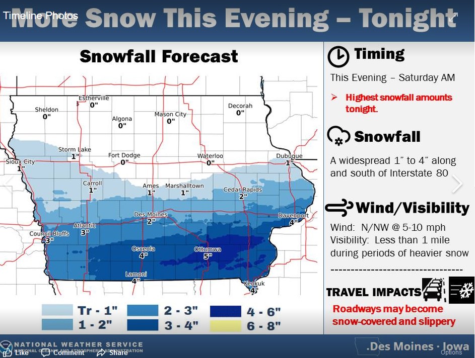 The snow is expected to last through the overnight hours, with most accumulation occurring between midnight- and 6-am Saturday. By noon Saturday, much of the snow should be east of our area. Hazardous travel is possible, so be prepared to slow down as roadways may be snow-covered and slippery.
Today: Mostly cloudy w/light snow or flurries (1/2” or less). High around 17. N @ 15-25.
Tonight: Cloudy w/light snow. Low 5. N @ 5-10.
Tomorrow: Cloudy w/light snow, mainly in the morning (1” total). High 13. N @ 10-15.
Sunday: Partly Cloudy. High 25.
Monday: P/Cldy. High 30.
Thursday’s High in Atlantic was 25. Our 24-hour Low was 2. As of 5-a.m. in Atlantic, we received .9” snow at the KJAN studios. Last year on this date our High was 32 and the Low was 8. The record High in Atlantic on this date was 59 in 1954, 2000 & 2009, and the Low was -36 in 1975.
The National Weather Service has cancelled a Winter Weather Advisory and Winter Storm Warning for much of the area mentioned Thursday, with the exception of Carroll and Greene Counties, where a Winter Weather Advisory remains in effect until 6-a.m.
The National Weather Service has updated its list of counties in Iowa that under a Winter Weather Advisory. In the KJAN listening area, Carroll County (Which was under a Winter Weather Advisory), was upgraded to a Winter Storm Warning. The warning is in effect from 3-p.m. today until 9-a.m. Friday. Persons in the warned area can expect heavy snow, with accumulations for 4-to 7-inches, along with northerly winds of 15-to 25-miles per hour, which will create difficult driving conditions, including during the commute Friday morning.
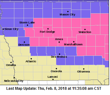
Counties in purple are under a Winter Weather Advisory; Counties in Pink are in a Winter Storm Warning.
Counties that remain under a Winter Weather Advisory from 9-p.m. tonight until 9-a.m. Friday, include Audubon-Crawford-Guthrie and Dallas, in our listening area. Snow of 2-to 4-inches can be expected, along with northwest winds of 15-to 25-miles per hour, which can create blowing and drifting of snow. Plan on slippery road conditions and reduced visibilities at times.


