
Today: Partly cloudy. High 44. NW @ 10-15.
Tonight: Mostly clear. Low 18. NW @ 5.
Tomorrow: P/Cldy. High 42. NW @ 10.
Wednesday: P/Cldy. High near 60.
Thursday: Mo. Cldy. High 52.
Sunday’s High in Atlantic was 39. Our Low this morning, 29 (as of 5:25-a.m.). We received a trace of snowfall Sunday morning, in Atlantic. Last year on this date our High was 38 and the Low was 24. The record High in Atlantic on this date was 74 in 1938. The Record Low was -21, in 1998.
Today: Cloudy w/a 60% chance of snow, mainly before 10am. High near 41. N/NE wind 5 to 10 mph. New snow accumulation of less than a half inch possible.
Tonight: Cloudy to partly cloudy, with a low around 24. North northwest wind around 10 mph.
Monday: Sunny, with a high near 45. Northwest wind 10-20 mph.
Monday Night: Partly cloudy, with a low around 20. North wind around 10 mph.
Tuesday: Sunny, with a high near 39.
Tuesday Night: Mostly clear, with a low around 19.
Wednesday: Sunny, with a high near 54.
Wednesday Night: Mostly clear, with a low around 33.
Saturday’s High in Atlantic was 49. Snow began at around 6-a.m. Our Low this morning was 30. Last Year on this date, the High in Atlantic was 30 and the Low was 20. The Record High in Atlantic on this date was 69 in 1900, and the Record Low was -22 in 1948.
Today: P/Cldy to Cldy w/a 30% chance of afternoon showers. High 47. SE @ 5-10.
Tonight: Cloudy w/rain changing to snow. Low 31. NE @ 5-10.
Tomorrow: Cldy w/snow-rain mix. High 37. N @ 5-10. (1-2” snow possible, total)
Sunday night: P/Cldy. Low 23.
Monday: Mostly Sunny. High 41.
Tuesday: Mo. Sunny. High 42.
Wednesday: Mo. Sunny. High 51.
Friday’s High in Atlantic was 45. Our Low was 24. Last year on this date our High was 28 and the Low was 15. The record High in Atlantic on this date was 75 in 2015. The Record Low was -8, in 1948.
The National Weather Service says a winter system is likely to bring snow to portions of Iowa Saturday evening through Sunday morning. Confidence in the timing of this event is high. However, confidence is low to medium regarding the location of potential higher amounts of snow. At this time, it appears 1 to 2 inches of snow will in an area roughly along and south of Interstate 80, with around 1 inch falling across the rest of our area.
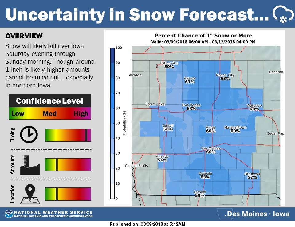 There is a chance, however, that higher totals of snow may fall across northern Iowa. In this scenario, most of the snow will fall overnight Saturday, leading to potentially slippery roads and hazardous travel Saturday night into Sunday morning. Keep it tuned here today as we will have a more accurate and higher confidence forecast by this afternoon. For next week, quiet weather conditions and above normal temperatures are expected. By next Thursday and Friday, highs in the 50s and even 60s is possible! Again, check back throughout today and this weekend, for forecast updates.
Today: P/Cldy to Cldy. High 42. SE @ 10-15.
Tonight: Mo. cloudy. Low 30. SE @ 5-10.
Tomorrow: Cldy w/light rain mainly during the afternoon. High 45. SE @ 10-20,
Sunday: Mostly cloudy w/light snow or flurries in the morning. High 36
Monday: P/Cldy. High 42.
Thursday’s High in Atlantic was 37. Our Low (thru 5-a.m. today) was 14 (at 5-a.m., it was 27). Last year on this date our High was 49 and the Low was 15. The record High in Atlantic on this date was 76 in 1986. The Record Low was -10, in 1912.
Today: Partly sunny. High 38. NW @ 10-15.
Tonight: Partly cloudy. Low 20. SE @ 5.
Tomorrow: P/Cldy. High 42. SE @ 10-15.
Saturday: Mostly cloudy w/light rain late. High 45
Sunday: Mostly cloudy w/light snow or flurries. High 36.
Wednesday’s High in Atlantic was 30. Our Low this morning was 14. We received a Trace of snow yesterday, in Atlantic, with some occasional flurries. Last year on this date our High was 55 and the Low was 29. The record High in Atlantic on this date was 76 in 1986. The Record Low was -12, in 1982.
Today: Partly cloudy to cloudy w/a chance of flurries this afternoon. High 35. NW @ 10-20.
Tonight: Decreasing clouds. Low 15. NW @ 10-20.
Tomorrow: P/Cloudy. High 39. Winds variable @ 5-10.
Friday: Mostly cloudy. High around 42
Saturday: Mostly cloudy w/a chance of light rain late. High near 45.
Tuesday’s High in Atlantic was 32. Our this morning (as of 5-a.m.) was 19. We received four-tenths of an inch of snowfall Tuesday (.4″), for a total of 1.1 inches. The powdery snow amount to just a Trace of precipitation. Last year on this date, the High was 56 and the Low was 27. The All-Time record High in Atlantic on this date was 78, in 2000. The Record Low was -11 in 1982.
The Shelby County Emergency Management Agency, in conjunction with Fire Chiefs in Shelby County, has begun to issue their bi-weekly, local outdoor fire danger updates. The updates will continue until ground conditions improve. As of Monday, the Fire Danger in Shelby County was “Low.” The next update will be on Thursday.
Today: **Winter Weather Advisory for snow & blowing snow**
Light snow or flurries. High 33. W-NW @ 15-30. (Less than 1/2” new snow expected)
Tonight: P/Cldy to Cldy. Low 24. NW @ 10-20.
Tomorrow: P/Cloudy to Cldy. High 35. NW @ 10-20.
Thursday: P/Cldy. High around 40
Friday: Mostly cloudy. High near 42.
Monday’s High in Atlantic was 47. Our Low this morning was 25. We received seven-tenths of an inch (.7″) of snow thru 7-a.m. today. Yesterday, we also received .04” inch of rain and/or drizzle. Total precipitation (melted snow and rain), was .10″ Last year on this date our High was 76 and the Low was 35. The record High in Atlantic on this date was 76 in 2017. The Record Low was -20, in 1960.
Monona-Harrison-Shelby-Pottawattamie Counties…A WINTER WEATHER ADVISORY REMAINS IN EFFECT UNTIL 6 PM TODAY…
Snow and blowing snow. Winds gusting as high as 50 mph will cause whiteout conditions in blowing snow. Additional snow accumulations up to 2 inches are expected.
Sac-Crawford-Carroll-Audubon-Guthrie-Cass Counties…A WINTER WEATHER ADVISORY REMAINS IN EFFECT UNTIL 3 PM TODAY.
Snow expected. Additional snow accumulations of 1 to 3 inches. Winds will become northwest and strengthen later today with areas of blowing snow, especially in the heavier snow squalls.
Plan on slippery road conditions, including during the morning commute on Tuesday. Be prepared for reduced visibilities, down to a mile or less at times.
PRECAUTIONARY/PREPAREDNESS ACTIONS…
A Winter Weather Advisory for snow means periods of snow will cause primarily travel difficulties. Be prepared for snow covered roads and limited visibilities, and use caution while driving.
The latest road conditions for the state you are calling from can be obtained by calling 5 1 1.


