
(These are 24-hour rainfall reports to the NWS, ending at 7-a.m. today [5/1]).
Atlantic (KJAN), .22″
Atlantic (7.1 miles N/NE), .27″
Creston (8.3 miles W/NW), .09″
Council Bluffs, .34″
Dunlap, .30″
Earling (2.4 miles SE), .31″
Elk Horn, .18″
Hastings (Mills County), .12″
Massena, .19″
Missouri Valley, .25″
New Market, .02″
Persia, .52″
Sac City, .40″
Schleswig, .13″
Thurman, .16″
Woodbine, .12″
Other (Unofficial rainfall amounts contributed to the media)
Audubon, .15”
Avoca, .40”
Glenwood, .05”
Lenox, .35”
Marne,.30”
Neola, .50”
Oakland, .20”
Shenandoah, .03”
Stanton, .04”
Today: Mostly cloudy & breezy, w/a 50% chance of showers & thunderstorms. A high near 66. W/NW winds 10-25 mph this afternoon.
Tonight: Partly cloudy, with a low around 44. N/NW @ 10-20.
Tomorrow: Partly sunny w/a 40% chance of showers & thunderstorms. High near 61. N/NW @ 10-20 mph.
Tom. Night: Mostly clear, with a low around 38.
Saturday: Sunny, with a high near 66.
Sunday: Sunny, with a high near 71.
Monday: Sunny, with a high near 73.
Wednesday’s High in Atlantic was 67. The Low was 47. We received .16″ rain at KJAN as of 6-a.m. Last year on May 1st, the High in Atlantic was 66 and the Low was 45. The Record High was 90 in 1965. The Record Low was 24 in 1909. Sunrise: 6:17; Sunset: 8:17.
Today: Mostly cloudy w/a 60% chance of showers & thunderstorms. A high near 61. E/SE winds 10-20 mph. New rainfall amounts between a tenth and quarter of an inch, except higher amounts possible in thunderstorms.
Tonight: Cloudy w/a 40% chance of showers & thunderstorms. A low around 52.
Tomorrow: A 30% chance of showers, mainly after 1pm. High near 65. NW winds 10-20 mph.
Tom. Night Partly cloudy, with a low around 44.
Friday: Partly sunny w/a 40% chance of showers. A high near 63.
Saturday: Sunny, with a high near 71.
Sunday: Sunny, with a high near 75.
Tuesday’s High in Atlantic was 68. Our Low this morning was 40. Last year on April 30th, the High in Atlantic was 75 and the Low was 43. The Record High was 92 in 1926. The Record Low was 19 in 1958. Sunrise: 6:19; Sunset: 8:16.
Atlantic (KJAN), .01”
Atlantic (7.1 miles N/NE), .06”
Creston (8.3 miles W/NW), Trace of rain
Elk Horn, .02”
New Market (4.7 miles N), Trace of rain
DES MOINES, Iowa — Stormy weather made appearances through parts of Iowa Monday afternoon and night. Strong to severe storms developed in western and northwestern counties, resulting in several tornado warnings, and which dropped hail and rain. A tornado warning that was issued for northeastern Cass County at around 8:45-p.m., was canceled at 9:20-p.m. or about 15 minutes ahead of its expected expiration.
Eleven northwest Iowa counties were under a severe thunderstorm watch through 11 p.m. Monday, while other counties including Cass, were under a Tornado Watch until midnight. Lewis Firefighter Tim Pope sent KJAN a photo of a funnel cloud that appeared just west of Cold Springs State Park, at around 8:36-p.m., Monday.
Thunderstorm wind damage about three-miles west of Anita was reported at around 9:04-p.m. Monday, by a trained storm spotter, who said there numerous tree branches down, and nickel-sized hail. Three-quarters inch (.75″) diameter hail (dime-to-penny-size) was reported in Adair a little after 9-p.m., Monday.
Complicating the situation, was the fact the National Weather Service’ weather radio system in Valley, Nebraska, was down during the storm events for mandatory maintenance, which means persons who relied solely on their weather radios for bulletins, had to rely instead on other forms of notification, including their local, county messages from Alert Iowa, and/or local media. The NWS Weather Radio out of Nebraska, which serves southwest Iowa, was expected to be down through Wednesday, April 30th.
Today: Sunny & breezy, with a high near 65. N/NW winds 5-15 mph w/gusts to near 25.
Tonight: Partly cloudy, with a low around 45. East wind 5-10 mph.
Tomorrow: A 60% chance of showers & thunderstorms. A high near 61. E/SE winds 10-20 mph.
Tom. Night: A 50% chance of showers & thunderstorms. Low around 50.
Thursday: A 40% of showers, with some thunderstorms possible. A high near 68.
Thursday Night: Partly cloudy, with a low around 43.
Friday: A slight chance of showers & some possible thunderstorms, otherwise mostly sunny. A high near 64.
Monday’s High in Atlantic was 83. Our Low this morning was 44. We received just .01″ rain last night at KJAN. Last year on April 29th, the High in Atlantic was 66 and the Low was 43. The Record High was 93 in 1987. The Record Low was 22 in 1958. Sunrise: 6:20; Sunset: 8:15.
(Radio Iowa) – Iowans are being warned to be prepared for foul weather later today (Monday) and into tonight. National Weather Service meteorologist Rod Donavon says severe thunderstorms are possible across a wide section of the state. “We have a moderate risk out across northern Iowa, which is generally along and north of Highway 20, that is where the greatest risk for severe weather is at, and the rest of the state’s generally in an enhanced risk,” Donavon says. “We’re expecting storms to develop here later this afternoon, especially across northern Iowa, with the threat for few tornadoes, in addition to large hail and damaging winds.”
If it seems like we’ve been having a lot of severe weather in recent weeks, he says you’re not imagining things. “It’s really typical for this time of year,” Donavon says. “Once we get into this more volatile weather pattern, which is typically that early spring portion of the year, where we have a lot of stronger systems move through, we can have some of these stronger to severe weather episodes across the Midwest.” 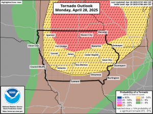
Iowa’s forecast also calls for broad temperature swings, with highs in the 80s likely for most of the state today, while the cold front arriving tonight should knock highs into the 60s tomorrow.
Today: Cloudy w/a slight chance of showers & thunderstorms between 10am and noon. Gradually becoming mostly sunny, with a high near 82. Winds S @ 25-45 mph.
Tonight: Partly cloudy w/a 30% chance of showers and thunderstorms before 7pm. Some of the storms could be severe, with large hail, damaging winds & isolated tornadoes. Low around 44. S/SW @ 15-40 becoming NW after midnight.
Tomorrow: Sunny, with a high near 67. N/NW winds @ 10-25 mph.
Tom. Night: A 20% chance of showers after midnight. Partly cloudy. Low around 45.
Wednesday: Mostly cloudy w/a 60% chance of showers likely & possibly a thunderstorm. High near 66.
Wed. night: A 50% chance of showers and thunderstorms. Low around 51.
Thursday: A 40% chance of showers. Partly sunny. A high near 70.
Sunday’s High in Atlantic was 65 (24-hour High ending at 7-a.m. today). The Low was 53. Last year on April 28th, the High in Atlantic was 67 and the Low was 46. The Record High was 94 in 1910. The Record Low was 26 in 1965. Sunrise: 6:21; Sunset: 8:14.
Today: Cloudy, w/a slight chance of drizzle this morning. Breezy. A high near 65. S/SE winds 10-25 mph.
Tonight: Cloudy & breezy w/a 30% chance of showers & thunderstorms, mainly after midnight. Low around 60. S/SE @ 15-25 mph.
Tomorrow: Partly sunny & windy, w/a 50% chance of showers & thunderstorms, mainly between noon and 1pm. Some of the storms could be severe, with large hail, damaging winds & isolated tornadoes. A high near 82. Winds S @ 20-40 mph. file:///C:/Users/Owner/Downloads/DssPacket.pdf
Tom. Night: A 30% chance of showers & thunderstorms. Some of the storms could be severe. Windy. Low around 45.
Tuesday: Sunny & breezy, with a high near 67. N/NW winds 10-25 mph.
Wednesday: Partly sunny w/a 50% chance of showers and thunderstorms. A high near 68.
Saturday’s High in Atlantic was 63. The Low was 41. Last year on April 27th, the High in Atlantic was 63 and the Low was 52. The Record High was 90 in 1989. The Record Low was 23 in 1950. Sunrise: 6:23; Sunset: 8:13.
Today: Mostly sunny, with a high near 62. East northeast wind 10-20 mph.
Tonight: Mostly cloudy w/a slight chance of showers, late. A low around 48.
Sunday: Mo. Cldy & breezy w/a slight chance of showers & thunderstorms. High near 68. Winds SE @ 15-25 mph.
Sunday Night: A 40% chance of showers & thunderstorms. Low around 58.
Monday: Partly sunny w/a 60% chance of showers and thunderstorms, mainly after 1pm. A high near 82. Winds S @ 20-35 mph.
Tuesday: Sunny, with a high near 65.
Wednesday: Mostly sunny, with a high near 69.
Friday’s High in Atlantic was 57. Our Low this morning was 42. Last year on April 26th, the High in Atlantic was 68 and the Low was 49. The Record High was 92 in 1987 & 1989. The Record Low was 15 in 1907. Sunrise: 6:24; Sunset: 8:12.


