
Today: Partly sunny-to-sunny. A high near 73. Northeast breeze @ 5-15 mph w/gusts to near 20.
Tonight: Mostly clear, with a low around 43.
Tomorrow: Sunny, with a high near 77. Winds east at around 5 mph in the afternoon.
Tom. Night: Mostly clear, with a low around 48.
Saturday: Sunny, with a high near 82. Winds south at around 5-10 mph in the afternoon.
Saturday Night: Clear, with a low around 52.
Sunday: Sunny, with a high near 81.
Monday: Sunny & breezy, with a high near 79.
Today: Mostly cloudy w/a slight chance of showers & thunderstorms this afternoon. high near 76. Winds E/NE at 5-10 mph.
Tonight: Mo. Cloudy w/a 30% chance of showers & thunderstorms, mainly before midnight. Low around 51.
Tomorrow: Mostly sunny, with a high near 73. E/NE winds 10-20 mph.
Tom. Night: Mostly clear, with a low around 44.
Friday: Sunny, with a high near 75. E/NE winds around 5 mph.
Saturday: Sunny, with a high near 79.
Sunday: Sunny, with a high near 79.
Today: Sunny, with a high near 76. Winds becoming east 5 to 10 mph this afternoon.
Tonight: Increasing clouds, with a low around 50.
Tomorrow: Partly sunny w/a 20% chance of afternoon showers. A high near 75. E/NE winds 5-10.
Tom. Night: Mostly cloudy w/a 20% chance of showers & thunderstorms through midnight. Low around 51.
Thursday: Mostly sunny, with a high near 72. East wind 7 to 11 mph.
Thursday Night: Mostly clear, with a low around 46.
Friday: Sunny, with a high near 75.
Saturday: Sunny, with a high near 80.
Today: Sunny, with a high near 74. Winds NE this afternoon @ 5-10 mph.
Tonight: Mostly clear, with a low around 45.
Tomorrow: Sunny, with a high near 75. E winds 5-10 mph in the afternoon.
Tom. Night: Mostly cloudy, with a low around 50.
Wednesday: A slight chance of afternoon & evening showers or thunderstorms. A high near 74.
Wed. Night: A slight chance of showers & thunderstorms. A low around 52.
Thursday: Partly sunny w/a slight chance of showers. A high near 74.
Friday: Sunny, with a high near 73.
Today: Sunny, with a high near 71. Calm wind becoming east northeast around 5 mph this afternoon.
Tonight: Mostly clear, with a low around 44.
Monday: Sunny, with a high near 73. E/NE winds 5-10 in the afternoon.
Monday Night: Mostly clear, with a low around 45.
Tuesday: Mostly sunny, with a high near 76. E winds around 5 mph in the afternoon.
Tuesday Night: Mostly cloudy, with a low around 52.
Wednesday: A 30% chance of afternoon showers. A high near 72.
Wed. Night: A slight chance of showers and thunderstorms before midnight. A low around 50.
Thursday: Mostly sunny, with a high near 72.
Saturday’s High in Atlantic was 66. Our Low this morning, was 36. Last year on May 4th, the High in Atlantic was 62 and the Low was 37. The Record High was 91 in 1918. The Record Low was 18 in 1907. Sunrise: 6:14; Sunset: 8:21.
Today: Sunny, with a high near 63. North wind 5 to 10 mph.
Tonight: Mostly clear, with a low around 41.
Tomorrow: Sunny, with a high near 70. E/NE winds around 5 mph in the afternoon.
Tom. Night: Mostly clear, with a low around 44.
Monday: Sunny, with a high near 72.
Tuesday: Mostly sunny, with a high near 74.
Wednesday: Partly sunny w/a 30% chance of showers after 1pm. A high near 72.
Friday’s High in Atlantic was 61. The Low was 36. We received .45″ rain at KJAN, Friday. Last year on May 3rd, the High in Atlantic was 71 and the Low was 37. The Record High was 87 in 1895, 1949 & 1968. The Record Low was 25 in 1900. Sunrise: 6:14; Sunset: 8:19.
*citizen reports to the media (not a NWS report)
Atlantic (KJAN), .07”
Atlantic (7.1 miles N/NE), .02”
Anita, .13*
Audubon, .15*
Clarinda, .10”*
Corning, Greenfield, Glenwood & Guthrie Center, .05” (each)*
Creston (8.3 miles W/NW), .06”
Earling (2.4 miles SE), .18”
Elk Horn, .12”
Greenfield, .05”*
Harlan, .35″*
Hastings (1.5 miles N), .14”
Kirkman (1 mile SE), .13”
Marne, .30”*
Massena, .15”
New Market (4.7 miles N), .18”
Oakland, .20”*
Pacific Junction (3.1 miles N), .21”
Red Oak, .15”*
Shenandoah, .10”*
Stanton, .04”*
Treynor,. 41”*
Thurman, (7.1 miles S/SE), .24”
Wiota, .46”*
Today: Cloudy, w/a 50% chance of showers & possible late day thunderstorms. A high near 59. Winds North @ 5 to 10 mph.
Tonight: A slight chance of showers & thunderstorms this evening. Gradually becoming mostly clear. Low around 38.
Tomorrow: Sunny, with a high near 64. North wind 5 to 10 mph.
Tom. Night: Mostly clear, with a low around 39.
Sunday: Sunny, with a high near 70.
Sunday Night: Mostly clear, with a low around 42.
Monday: Mostly sunny, with a high near 70.
Tuesday: Mostly sunny, with a high near 74.
Thursday’s High in Atlantic was 64. The Low was 41. We received .07″ rain at KJAN over the 24-hour period ending today at 7-a.m.. Last year on May 2nd, the High in Atlantic was 62 and the Low was 37. The Record High was 91 in 1968. The Record Low was 17 in 1908. Sunrise: 6:15; Sunset: 8:18.
(Radio Iowa) – April had plenty of showers at times, but state climatologist Justin Glisan says overall precipitation for the month was near normal. “We’re coming in about three-point-four (3.4) inches of precipitation, and that’s about three-tenths of an inch below average. So, near normal across much of the state, drier conditions eastern, and then across portions of southern Iowa,” Glisan says. Residents of portions of northern Iowa will tell you the April showers were anything but normal.
“From north central into northeastern Iowa, stations up that way were anywhere from two to four inches above average. Some stations around Cedar Rapids and Waterloo had a month’s worth of precipitation within a seven-day period towards the end of the month,” he says.” Glisan says those areas were balanced out in the statewide average by the drier areas. Glisan says April was just a little warmer than normal when statewide readings are calculated.
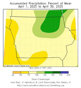
(Map from the Department of Ag Climatological Bureau.)
“About a degree above average for the statewide average temperature. Now you look where we had more rainfall, more cloud cover, that northeastern corner, they were near average. And then slightly warmer conditions across southern Iowa, and that meshes well with drier conditions, more sunshine,”Glisan says.
Glisan says we had two big storm events in April, including one with a lot of hail, but there were no serious issues with either storm.
(Atlantic, Iowa) – April Weather data for Atlantic (Compiled here at KJAN – the official National Weather Service reporting site), shows we were slightly warmer in both the average High and Low for the month. Typically, April in Atlantic would have an average High of 62. Last month, the average High temperature was 64 degrees.
The average low is normally around 50. Last month, the average Low was 37. And, while rainfall during the month of April in Atlantic is typically around 3.43-inches, we did better than that last month, when we received 3.70” of rain.
The warmest day last month was 83 on April 29th. The coldest temperature was 18 degrees, set on the 7th & 8th of April.
Looking ahead to the month of May we find the High temperature is 73 degrees, while the average Low is 49. Precipitation typically amounts to 4.32-inches.
Check back with us during the first week of June 2025, to see how our actual weather data compared to the historical averages.


