BULLETIN - IMMEDIATE BROADCAST REQUESTED
Severe Thunderstorm Warning
National Weather Service Omaha/Valley Nebraska
939 PM CDT WED JUN 6 2018

The National Weather Service in Omaha has issued a

* Severe Thunderstorm Warning for...
  Southwestern Pottawattamie County in southwestern Iowa...
  East central Douglas County in east central Nebraska...

* Until 1015 PM CDT.

* At 939 PM CDT, a severe thunderstorm was located over northwestern
  Council Bluffs, or 6 miles east of Omaha, moving southeast at 20
  mph.

  HAZARD...60 mph wind gusts.

  SOURCE...Radar indicated.

  IMPACT...Expect damage to roofs, siding, and trees.

* Locations impacted include...
  Southeastern Omaha, Council Bluffs, Carter Lake, Lake Manawa State
  Park and Narrows River Park.

This includes the following highways...
 Interstate 29 between mile markers 43 and 58.
 Interstate 80 in Iowa between mile markers 1 and 8.
 Interstate 80 in Nebraska near mile marker 454.

PRECAUTIONARY/PREPAREDNESS ACTIONS...

For your protection move to an interior room on the lowest floor of a
building.
Cass IA-Union IA-Adams IA-Adair IA-
906 PM CDT WED JUN 6 2018
…A SEVERE THUNDERSTORM WARNING REMAINS IN EFFECT UNTIL 945 PM CDT
FOR SOUTHEASTERN CASS…WESTERN UNION…ADAMS AND SOUTHWESTERN ADAIR
COUNTIES…
At 906 PM CDT, a severe thunderstorm was located 10 miles northeast
of Lake Icaria, or 11 miles southwest of Greenfield, moving south at
25 mph.
HAZARD…60 mph wind gusts and quarter size hail.
SOURCE…Trained weather spotters.
IMPACT…Hail damage to vehicles is expected. Expect wind damage to
roofs, siding, and trees.
Locations impacted include…
Creston, Corning, Lenox, Lake Icaria, Fontanelle, Massena, Prescott,
Bridgewater, Cromwell, Kent, Nodaway Park, Corning Municipal Airport
and Lake Icaria State Park.
PRECAUTIONARY/PREPAREDNESS ACTIONS…
For your protection move to an interior room on the lowest floor of a
building.
Continuous cloud to ground lightning is occurring with this storm.
Move indoors immediately. Lightning is one of nature`s leading
killers. Remember, if you can hear thunder, you are close enough to
be struck by lightning.
Severe Thunderstorm Warning
National Weather Service Des Moines IA
855 PM CDT WED JUN 6 2018

The National Weather Service in Des Moines  has issued a

* Severe Thunderstorm Warning for...
  Southeastern Cass County in southwestern Iowa...
  Western Union County in south central Iowa...
  Adams County in southwestern Iowa...
  Southwestern Adair County in southwestern Iowa...

* Until 945 PM CDT.

* At 855 PM CDT, a severe thunderstorm was located 10 miles west of
  Greenfield, moving south at 35 mph.

  HAZARD...60 mph wind gusts and quarter size hail.

  SOURCE...Radar indicated.

  IMPACT...Hail damage to vehicles is expected. Expect wind damage
           to roofs, siding, and trees.

* Locations impacted include...
  Creston, Corning, Lenox, Lake Icaria, Fontanelle, Massena,
  Prescott, Bridgewater, Cromwell, Kent, Nodaway Park, Corning
  Municipal Airport and Lake Icaria State Park.

PRECAUTIONARY/PREPAREDNESS ACTIONS...

For your protection move to an interior room on the lowest floor of a
building.

Large hail and damaging winds and continuous cloud to ground
lightning is occurring with this storm. Move indoors immediately.
Lightning is one of nature`s leading killers. Remember, if you can
hear thunder, you are close enough to be struck by lightning.
Cass IA-Guthrie IA-Audubon IA-Adair IA-
805 PM CDT WED JUN 6 2018

...A SEVERE THUNDERSTORM WARNING REMAINS IN EFFECT UNTIL 845 PM CDT
FOR CASS...SOUTHERN GUTHRIE...SOUTHERN AUDUBON AND ADAIR COUNTIES...

At 805 PM CDT, severe thunderstorms were located along a line
extending from 8 miles east of Walnut to 10 miles south of Stuart,
moving south at 20 mph.

HAZARD...60 mph wind gusts and quarter size hail.

SOURCE...Trained weather spotters.

IMPACT...Hail damage to vehicles is expected. Expect wind damage to
         roofs, siding, and trees.

Locations impacted include...
Atlantic, Greenfield, Stuart, Griswold, Anita, Exira, Adair,
Fontanelle, Elk Horn, Dexter, Lewis, Casey, Orient, Diamondhead Lake,
Massena, Menlo, Kimballton, Cumberland, Bridgewater and Brayton.

This includes Interstate 80 between mile markers 50 and 97.

PRECAUTIONARY/PREPAREDNESS ACTIONS...

For your protection move to an interior room on the lowest floor of a
building.

Continuous cloud to ground lightning is occurring with these storms.
Move indoors immediately. Lightning is one of nature`s leading
killers. Remember, if you can hear thunder, you are close enough to
be struck by lightning.
Severe Thunderstorm Warning
National Weather Service Des Moines IA
745 PM CDT WED JUN 6 2018

The National Weather Service in Des Moines  has issued a

* Severe Thunderstorm Warning for...
  Cass County in southwestern Iowa...
  Southern Guthrie County in west central Iowa...
  Southern Audubon County in west central Iowa...
  Adair County in southwestern Iowa...

* Until 845 PM CDT.

* At 745 PM CDT, severe thunderstorms were located along a line
  extending from 11 miles northeast of Walnut to near Stuart, moving
  south at 20 mph.

  HAZARD...60 mph wind gusts and quarter size hail.

  SOURCE...Radar indicated.

  IMPACT...Hail damage to vehicles is expected. Expect wind damage
           to roofs, siding, and trees.

* Locations impacted include...
  Atlantic, Greenfield, Stuart, Griswold, Anita, Exira, Adair,
  Fontanelle, Elk Horn, Dexter, Lewis, Casey, Orient, Diamondhead
  Lake, Massena, Menlo, Kimballton, Cumberland, Bridgewater and
  Brayton.

This includes Interstate 80 between mile markers 50 and 97.
Guthrie IA-Audubon IA-Adair IA-Cass IA-
725 PM CDT WED JUN 6 2018

...GUSTY WINDS TO 40 MPH AND DIME HAIL POSSIBLE...

At 724 PM CDT, Doppler radar was tracking strong thunderstorms along
a line extending from 6 miles east of Irwin to near Stuart. Movement
was south at 15 mph.

Dime size hail and winds in excess of 40 mph will be possible with
these storms.

Locations impacted include...
Audubon, Guthrie Center, Stuart, Anita, Exira, Adair, Elk Horn,
Dexter, Casey, Diamondhead Lake, Menlo, Kimballton, Brayton, Audubon
County Airport, Anita Municipal Airport and Lake Anita State Park.

PRECAUTIONARY/PREPAREDNESS ACTIONS...

Frequent cloud to ground lightning is occurring with these storms.
Lightning can strike 10 miles away from a thunderstorm. Seek a safe
shelter inside a building or vehicle.

These storms may intensify, so be certain to monitor local radio
stations and available television stations for additional information
and possible warnings from the National Weather Service.

&&

A Severe Thunderstorm Watch remains in effect until 1000 PM CDT for
central, south central, southwestern and west central Iowa.
Severe Thunderstorm Warning
National Weather Service Des Moines IA
629 PM CDT WED JUN 6 2018

The National Weather Service in Des Moines  has issued a

* Severe Thunderstorm Warning for...
  Northwestern Audubon County in west central Iowa...
  Southeastern Crawford County in west central Iowa...
  Southwestern Carroll County in west central Iowa...

* Until 730 PM CDT.

* At 628 PM CDT, a severe thunderstorm was located over Manning, or
  14 miles east of Denison, moving south at 10 mph.

  HAZARD...Ping pong ball size hail and 60 mph wind gusts.

  SOURCE...Radar indicated.

  IMPACT...People and animals outdoors will be injured. Expect hail
           damage to roofs, siding, windows, and vehicles. Expect
           wind damage to roofs, siding, and trees.

* Locations impacted include...
  Manning, Templeton, Halbur, Gray, Aspinwall and Manning Municipal
  Airport.

PRECAUTIONARY/PREPAREDNESS ACTIONS...

Prepare immediately for large hail and deadly cloud to ground
lightning. Seek shelter inside a well-built structure. Stay away from
windows.
Severe Thunderstorm Warning
IAC015-049-073-077-153-070000-
/O.NEW.KDMX.SV.W.0105.180606T2257Z-180607T0000Z/

BULLETIN - IMMEDIATE BROADCAST REQUESTED
Severe Thunderstorm Warning
National Weather Service Des Moines IA
557 PM CDT WED JUN 6 2018

The National Weather Service in Des Moines  has issued a

* Severe Thunderstorm Warning for...
  Northwestern Polk County in central Iowa...
  Southeastern Greene County in west central Iowa...
  Guthrie County in west central Iowa...
  Southern Boone County in central Iowa...
  Dallas County in central Iowa...

* Until 700 PM CDT.

* At 556 PM CDT, severe thunderstorms were located along a line
  extending from near Big Creek Lake to 7 miles west of Perry, moving
  south at 35 mph.

  HAZARD...70 mph wind gusts and quarter size hail.

  SOURCE...Radar indicated.

  IMPACT...Hail damage to vehicles is expected. Expect considerable
           tree damage. Wind damage is also likely to mobile homes,
           roofs, and outbuildings.

* Locations impacted include...
  West Des Moines, Urbandale, Clive, Waukee, Grimes, Perry,
  Jefferson, Adel, Guthrie Center, Madrid, Stuart, Dallas Center,
  Earlham, Granger, Panora, De Soto, Woodward, Van Meter, Jordan
  Creek Town Center and Lake Panorama.

This includes Interstate 80 between mile markers 100 and 121.

PRECAUTIONARY/PREPAREDNESS ACTIONS...

For your protection move to an interior room on the lowest floor of a
building.

Prepare immediately for large hail and damaging winds. People outside
should move immediately to shelter inside a strong building. Stay
away from windows.

Large hail and damaging winds and continuous cloud to ground
lightning is occurring with these storms. Move indoors immediately.
Lightning is one of nature`s leading killers. Remember, if you can
hear thunder, you are close enough to be struck by lightning.

&&
A Severe Thunderstorm Watch has been issued until 10-p.m. for the following counties in the KJAN listening area: ADAIR ADAMS AUDUBON CARROLL CASS CRAWFORD DALLAS FREMONT GUTHRIE HARRISON MADISON MILLS MONONA
MONTGOMERY PAGE POTTAWATTAMIE RINGGOLD SAC SHELBY TAYLOR and UNION.
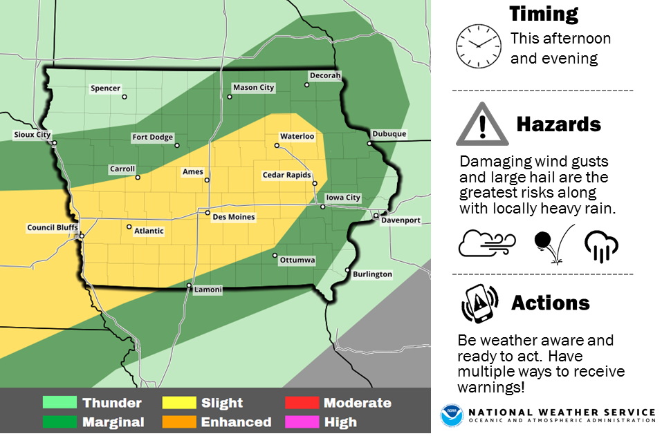
Severe Thunderstorm Watch until 10-p.m. for areas shaded in light mauve/pink
A Severe thunderstorm watch means conditions are favorable for the development of severe storms in and close to the watch area. The primary threat from any storms that develop this evening and tonight appear to be damaging winds, dangerous hail and heavy rain.
Stay tuned for further weather updates and prepare to seek shelter should severe weather threaten.
A severe thunderstorm by definition is a thunderstorm that produces one inch hail or larger in diameter and/or winds equal or exceed 58 miles an hour.
Strong to severe thunderstorms remain forecast today into tonight for the KJAN listening area. Large hail and damaging thunderstorm wind gusts look to be the main threat later this afternoon into tonight. Heavy rain is also anticipated and may lead to localized flash flooding by tonight. The weather pattern will stay active Thursday into the weekend with periodic chances for thunderstorms. Severe weather potential is forecast Thursday and Friday.