
300 AM CDT Fri May 16 2025
A WIND ADVISORY IS IN EFFECT FOR MOST OF WESTERN/SOUTHWEST IOWA FROM 7 AM TODAY UNTIL 9 PM.
* WHAT…West winds 25 to 35 mph with gusts up to 45 mph expected.
* IMPACTS…Gusty winds will blow around unsecured objects. Tree limbs could be blown down and a few power outages may result.
PRECAUTIONARY/PREPAREDNESS ACTIONS…
Winds this strong can make driving difficult, especially for high profile vehicles. Use extra caution.
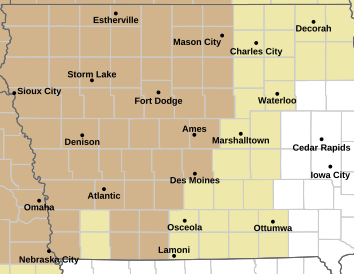
WIND ADVISORY IN EFFECT for counties in light brown
(Radio Iowa) – Strong thunderstorms rumbled across parts of northern Iowa this (Thursday) morning, and a wide area of the state is under a Wind Advisory today. The Advisory covers 34 counties in northwest, west-central and north-central Iowa from noon until 8 o’clock tonight. In the KJAN listening area, Harrison, Monona, Sac, Crawford and Carroll Counties are included in the Wind Advisory.
Meteorologist Rod Donavon, at the National Weather Service, says the powerful winds can make driving difficult, especially for high-profile vehicles, so use extra caution. “We will have increasing winds behind that boundary where we’ll see some wind gusts up towards 45 miles an hour,” Donavon says, “and that will likely last into the early evening hours.” Some gusts may be over 50 miles an hour, and he says anything in your yard that’s not secure could vanish, while tree limbs might snap, causing power outages.
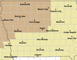
Wind Advisory for counties in light brown
Donavon says we may see a repeat tomorrow. “We will have another boundary, actually a colder front coming down during the day on Friday and that will be spreading strong winds across the state once again, mainly across the northern half,” he says. “That will have wind gusts up towards 45 miles per hour once again.”
After a warm week with unseasonable highs in parts of Iowa in the mid- to upper-80s, Donavon says it should be a cooler weekend, with highs in the 70s and the chance for rain Sunday night and Monday.
Today: Sunny & windy. A high near 78. Winds S/SW @ 15-20 mph this morning, gusting to near 35 mph this afternoon.
Tonight: Mostly clear & breezy, with a low around 54. Winds SW @ 10-20 w/gusts to near 30 mph.
Tomorrow: Mostly sunny & windy. A high near 75. Winds W @ 15-35 mph, gusting to near 40.
Tom. Night: Partly cloudy & windy. A low around 45. W/NW winds 15-35 mph.
Saturday: Sunny, with a high near 71.
Saturday Night: Mostly clear, with a low around 44.
Sunday: Mostly sunny, w/a 20% chance of afternoon showers/thunderstorms. Breezy. High near 75.
Wednesday’s High in Atlantic was 86. The Low was 58. Last year on May 15th, the High in Atlantic was 70 and the Low was 56. The Record High was 91 in 1894 & 2017. The Record Low was 29 in 1929, 1973 & 1983. Sunrise: 6:02; Sunset: 8:32.
Today: Sunny & breezy. A high near 87. SE. winds 10-20 w/gusts to near 25 mph.
Tonight: Partly cloudy w/a 30% chance of showers and thunderstorms. Low around 64. SE @ 15-25 mph. New rainfall amounts of less than a tenth of an inch, except higher amounts possible in thunderstorms.
Tomorrow: Sunny & windy with a high near 80. S winds 15-25 becoming westerly & gusting to near 35 mph.
Tom Night: Mostly clear & breezy, with a low around 54.
Friday: Mostly sunny & windy, with a high near 77.
Saturday: Sunny, with a high near 75.
Tuesday’s High in Atlantic was 85. The Low was 53. Last year on May 14th, the High in Atlantic was 78 and the Low was 49. The Record High was 97 in 2013. The Record Low was 29 in 1937. Sunrise: 6:03; Sunset: 8:31.
Today: Sunny, with a high near 85. South southeast wind 5 to 10 mph.
Tonight: Mostly clear, with a low around 59. South southeast wind 5 to 10 mph.
Tomorrow: Sunny & breezy. A high near 89. SE winds 5-15 mph gusting to around 25 in the afternoon.
Tom. Night: Partly cloudy w/a 30% chance of showers & thunderstorms. Low around 62.
Thursday: A slight chance of showers/thunderstorms through 1-p.m., then becoming mostly sunny & windy. High 78.
Thursday Night: Mostly clear & breezy, with a low around 54.
Friday: Mostly sunny & windy, with a high near 76.
Monday’s High in Atlantic was 83. The Low was 46. Last year on May 13th, the High in Atlantic was 65 and the Low was 49. The Record High was 95 in 1915. The Record Low was 23 in 1997. Sunrise: 6:04; Sunset: 8:30.
Today: Sunny, with a high near 83. South southeast wind 5 to 10 mph.
Tonight: Mostly clear, with a low around 55.
Tomorrow: Sunny, with a high near 86. South southeast wind 5 to 10 mph, with gusts to near 20 mph.
Tom. Night: Mostly clear, with a low around 59.
Wednesday: Sunny & breezy, with a high near 87.
Wed. Night: Partly cloudy w/a 30% chance of showers and thunderstorms. A low around 61.
Thursday: Sunny & windy, with a high near 80.
Sunday’s High in Atlantic was 84. Our Low this morning, was 43. Last year on May 12th, the High in Atlantic was 81 and the Low was 52. The Record High was 94 in 1956. The Record Low was 25 in 1895. Sunrise: 6:06; Sunset: 8:29.
Today: Sunny, with a high near 83. Southeast wind 5 to 10 mph.
Tonight: Clear, with a low around 50. Southeast wind 5 to 10 mph.
Monday: Sunny, with a high near 83. South southeast wind 5 to 10 mph.
Monday Night: Mostly clear, with a low around 55.
Tuesday: Sunny, with a high near 84. South southeast wind 5 to 10 mph, with gusts as high as 20 mph.
Tuesday Night: Mostly clear, with a low around 59.
Wednesday: Sunny & breezy, with a high near 87.
Wed. Night: A 40% chance of showers and thunderstorms through midnight otherwise mostly clear, with a low around 61.
Saturday’s High in Atlantic was 87. Our Low this morning, was 46. Last year on May 11th, the High in Atlantic was 81 and the Low was 41. The Record High was 95 in 2000. The Record Low was 27 in 1891, 1946 & 1981. Sunrise: 6:06; Sunset: 8:28.
Today: Sunny, with a high near 83. Wind E/NE this morning at 5-10 mph.
Tonight: Mostly clear, with a low around 50. East wind around 6 mph.
Tomorrow: Sunny, with a high near 82. South southeast wind 5 to 10 mph.
Tom. Night: Mostly clear, with a low around 52. South southeast wind 6 to 10 mph.
Monday: Sunny, with a high near 82. South southeast wind 5 to 11 mph with gust as high as 18.
Tuesday: Sunny, with a high near 84.
Wednesday: Sunny & breezy, with a high near 87.
Today: Sunny, with a high near 79. Winds becoming east at around 5 mph this afternoon.
Tonight: Mostly clear, with a low around 51.
Tomorrow: Sunny, with a high near 82. Winds becoming north/northeast at around 5-10 mph in the afternoon.
Tom. Night: Mostly clear, with a low around 53.
Sunday: Sunny, with a high near 83.
Monday: Sunny & breezy, with a high near 81.
Tuesday: Sunny & breezy , with a high near 83.
DES MOINES – Drought conditions have improved across the state despite below-normal rainfall in April, according to the latest Water Summary Update. The Iowa Department of Natural Resource’s says after a wetter-than normal March, April saw below-average precipitation across all regions of the state. However, recent spring rains have helped alleviate drought and abnormally dry conditions across Iowa. April’s average statewide precipitation was 3.33 inches, or 0.34 inches below normal.
The state also experienced warmer weather, with statewide temperatures averaging 50 degrees, or 1.4 degrees warmer than normal. At the end of April, Iowa’s Drought Plan dry conditions improved or remained the same in all drought regions except the southeast, which only degraded slightly. A drought watch issued in March for the northeast region has been removed as severe drought has significantly decreased. Conditions remain stable in the other drought regions, with the entire state carrying a normal drought designation.
According to the U.S. Drought Monitor (USDM), just over half of Iowa continues to experience abnormally dry conditions or drought conditions. The May precipitation outlook from the National Weather Service’s Climate Prediction Center indicates a chance of below-average precipitation across the northeast and eastern half of the state, and an equal chance for above, below, or near-average precipitation for the rest of the state. Reduced rainfall in May could raise concerns about deteriorating conditions. 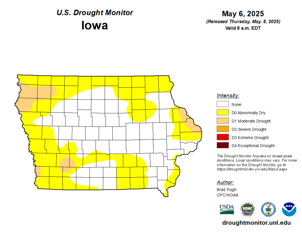
Iowa DNR Environmental Specialist Jessica Reese McIntyre says “Drought and dry conditions improved across the state due to spring rain in March and April, but most notably in northeast, west, and central Iowa. The drought watch issued in March for northeast Iowa has been removed. The National Weather Service precipitation outlooks predict an equal chance for the entire state for above, below, or normal precipitation for much of the state through July.”


