
Atlantic (at KJAN), .04″ *
Atlantic (7.1 miles N/NE), .07″ *
Bridgewater, .60 **
8.3-miles W/NW of Creston, .82″ *
5.4 miles N/NW of Dunlap, .9″ *
2.1 miles N/NE of Missouri Valley, 1.08″ *
.2 mile S/SE of Elk Horn (IA), .06″ *
Anita, .3″ **
Council Bluffs, .01″ *
Hastings, .04″ *
Marne, .2″ **
Massena, .26″ *
1.7-miles S/SW of Mondamin, 1.52″ *
New Market, .6″ *
7.1 miles S/SE of Thurman, .05 *
Wiota, .15″ **
Woodbine, .6″ *
********
* indicates official NWS reporting site data
**indicates reports to area media
Today: Cloudy w/a 40% chance of showers and/or thunderstorms. Breezy. A high near 59. Winds N @ 10-20 mph w/gusts to around 25 mph. New precipitation amounts between a tenth and quarter of an inch, except higher amounts possible in thunderstorms.
Tonight: Mostly cloudy, with a low around 41. Winds NW @ 15-25 mph.
Tomorrow: Partly sunny, with a high near 59. W/NW winds 15-30 mph.
Tom. Night: Partly cloudy w/a slight chance of showers. Low around 40.
Thursday: Mostly sunny, with a high near 63.
Thursday Night: Mostly clear, with a low around 39.
Friday: A 20 percent chance of showers after 1pm. Partly sunny, with a high near 64.
Monday’s High in Atlantic was 63. The Low was 52. We received .04″ rain. Last year on this date (May 20) the High in Atlantic was 84 & the Low was 63. The Record High was 95 in 1925. The Record Low was 26 in 1894. Sunrise: 5:56-a.m..; Sunset: 8:36-p.m.
(Radio Iowa) – National Weather Service forecasters say severe weather is possible late this (Monday) afternoon and tonight for wide areas of Iowa, including thunderstorms, hail and high winds. Meteorologist Donna Dubberke says those dry parts of the state have a good chance of getting soaked.
Up to three inches of rainfall is possible in some areas through tomorrow, bringing the chance of flash flooding, including the Interstate 80 corridor and south.
For Iowans who have outdoor plans for the Memorial Day weekend, that chance of rain is for late Saturday and much of Sunday.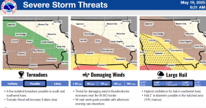
Atlantic (KJAN), .53″
Atlantic (7.1 miles N/NE), .54″
Council Bluffs, .58″
Creston, .51″
Dunlap, 1.2″
Earling, .67″
Elk Horn, .66″
Hamburg, 1.02″
Hastings, .96″
Massena, .68″
Missouri Valley, .81″
Mondamin, 1.24″
New Market, .66″
Onawa, 1.02″
Red Oak, .75″
(These and other rainfall amounts will be updated as the data comes in)
Unofficial reports (Those not received through the National Weather Service)
Anita, Wiota & Guthrie Center, .5″
Audubon, .75″
Bridgewater, .80″
Clarinda, .2″
Corning & Glenwood, .3″
Cumberland, .55″
Greenfield, .3″
Griswold, .4″
Harlan, .6″
Marne, .68″
Oakland, .4″
Shenand0ah, .25″
Stanton, .75″
Today: Periods of showers & thunderstorms. A high near 67. E/SE winds 20-35 mph. New rainfall amounts between a quarter and half of an inch possible.
Tonight: Showers and possible thunderstorms. Low around 51. E winds @ 15-30 mph. New rainfall amounts between a half and three quarters of an inch possible.
Tomorrow: Showers likely and possible thunderstorms. A high near 61. Winds NE winds becoming W/NW @ 10-25 mph. New precipitation amounts between a tenth and quarter of an inch, except higher amounts possible in thunderstorms.
Tom. Night: A 30% chance of showers. Low around 42. W/NW winds 15-25 mph. New precipitation amounts of less than a tenth of an inch possible.
Wednesday: Mostly cloudy & breezy w/a slight chance of showers. A high near 57.
Wed. Night: A slight chance of showers. Low around 39.
Thursday: Mostly sunny, with a high near 63.
Sunday’s High in Atlantic was 75. The Low was 41. We received .53″ rain overnight (through 7-a.m. today). Last year on this date (May 19) the High in Atlantic was 71 & the Low was 56. The Record High was 94 in 1934 & 1975. The Record Low was 22 in 1894. Sunrise: 5:58-a.m..; Sunset: 8:36-p.m.
Today: Sunny, with a high near 73. East wind 5 to 15 mph, with gusts to near 25 mph.
Tonight: Showers and possibly a thunderstorm. Low around 54.Winds east @ 15-30 mph. New rainfall amounts between a quarter and half of an inch possible.
Tomorrow: Showers and possibly a thunderstorm. High near 66. E/SE winds 20-35 mph. New rainfall amounts between a quarter and half of an inch possible.
Tom. Night: Showers and possibly a thunderstorm. Low around 53. Winds E @ 15-25 mph. New rainfall amounts between 1 and 2 inches possible.
Tuesday: Showers and possibly a thunderstorm. High near 64. New rainfall amounts between a half and three quarters of an inch possible.
Tue. Night: A 50% chance of showers and thunderstorms. Low around 42.
Wednesday: A 30% chance of showers, mainly before 1pm. Cloudy & breezy, with a high near 56.
Saturday’s High in Atlantic was 70. Our Low this morning, 40. Last year on this date (May 18) the High in Atlantic was 85 & the Low was 51. The Record High was 94 in 1934. The Record Low was 32 in 1891. Sunrise: 5:59-a.m..; Sunset: 8:35-p.m.
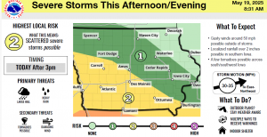
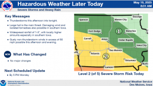
The Des Moines National Weather Service has produced a briefing regarding the following severe weather:
* WHAT – Slight (Level 2 of 5) Risk for severe weather with large hail, gusty winds, and locally heavy rainfall the primary hazards Sunday evening and again Monday afternoon/evening.
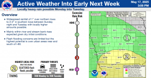
* WHERE & WHEN – Sunday evening to Monday morning in southwest Iowa and again Monday afternoon to evening in southern to central Iowa. Locally heavy rainfall risk is highest in southern Iowa, near to south of I-80 with heavy rain threat extending into Tuesday.
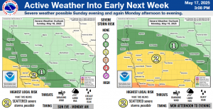
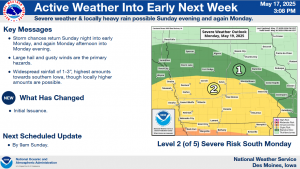
The briefing is available at https://www.weather.gov/media/dmx/DssPacket.pdf Additional severe storm specific information can be found at https://www.weather.gov/dmx/dsssevere.
The next email briefing is scheduled to be sent by around 9 AM Sunday May 18.
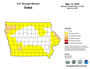
Iowa Drought Monitor graphic (5/15/25)
Today: Mostly cloudy, then gradually becoming sunny, with a high near 68. Breezy, with a northwest wind 15 to 30 mph.
Tonight: Mostly clear, with a low around 42. North northwest wind 5 to 10 mph becoming light and variable.
Tomorrow: Mostly sunny w/a high near 73. A slight chance of late afternoon showers. Winds E/NE @ 10-to 25 mph.
Tom. Night: A chance of showers and thunderstorms. Low around 53. Winds E @ 15-25.
Monday: Showers and possibly a thunderstorm. Windy, High near 66. W @ 20-30 mph.
Mon. Night: Showers and possibly a thunderstorm. Some of the storms could produce heavy rainfall. Low around 50. . New rainfall amounts between 1 and 2 inches possible.
Tuesday: Showers and possibly a thunderstorm. Breezy. High near 60.
Friday’s High in Atlantic was 71. Our Low was 46. Last year on this date (May 17) the High in Atlantic was 81 & the Low was 53. The Record High was 92 in 1908 & 1939. The Record Low was 32 in 1912 & 1973. Sunrise: 6-a.m.; Sunset: 8:34-p.m.
Today: Mostly cloudy, then gradually becoming sunny, with a high near 69. Breezy, with a northwest wind 14 to 20 mph, with gusts as high as 29 mph.
Tonight: Mostly clear, with a low around 41. North northwest wind 5 to 10 mph becoming light and variable.
Tomorrow: A 20 percent chance of showers after 4pm. Mostly sunny, with a high near 73. East northeast wind 9 to 15 mph, with gusts as high as 23 mph.
Tom Night: A slight chance of showers and thunderstorms, then showers and possibly a thunderstorm after 7pm. Low around 53. Breezy, with an east wind 15 to 18 mph, with gusts as high as 26 mph. Chance of precipitation is 90%
Monday: Showers and possibly a thunderstorm. High near 66. Windy, with an east wind 20 to 23 mph, with gusts as high as 31 mph. Chance of precipitation is 80%. New rainfall amounts between a quarter and half of an inch possible
Mon. Night: Showers and possible thunderstorms. Some of the storms could produce heavy rainfall. Low around 50. Breezy. Chance of precipitation is 100%. New rainfall amounts between 1 and 2 inches possible.
Tuesday: Showers and possible thunderstorms. High near 60. Breezy. Chance of precipitation is 90%.


