
(Radio Iowa) – While there’s no statewide air quality alert for Iowa today (Friday), one expert says more of those health advisories are likely in the weeks and months ahead, and they could be the “new normal” for years to come. Professor Patrick O’Shaughnessy, in the University of Iowa’s Department of Occupational and Environmental Health, says the smoke from Canadian wildfires was truly making the air over Iowa unhealthy with particulate matter, or P-M.
“It was high. I mean, the EPA wants the PM 2.5 and it’s 2.5 diameter particles, which are super-tiny little things, below 35 micrograms of those little particles per cubic meter of air,” O’Shaughnessy says, “and it was up over twice that over the past couple days.” People who are most at risk include those with asthma, C-O-P-D, and other heart or lung issues. During an alert, O’Shaughnessy says those folks need to keep their windows closed and use the furnace fan to recirculate the air. There are air purification devices — or ionizers — that may help to cleanse the air of particles, but he says your home or workplace’s H-VAC system may be the best defense.
“There’s different levels of filtration you can buy,” O’Shaughnessy says. “They’re more expensive for the higher filtration types, but they’re now available and people with compromised lungs and heart conditions should certainly try to do their best to purchase those better units because they do work.” The air quality advisory this week also said for otherwise healthy people to avoid going outside if possible, and to take it easy if they have to be outdoors, especially if they’re doing anything strenuous. What can they do to protect themselves? O’Shaughnessy says the choices are limited.
“Put on an N-95 certified mask and that will do it, but we all know maybe from our COVID experiences that it’s no fun trying to breathe through one of those things,” O’Shaughnessy says. “So then you add kind of an extra metabolic load on yourself trying to pull air through a mask.” The Air Quality Index for Des Moines reached 104 on Wednesday, which is considered “unhealthy for sensitive groups.” The “moderate” range is from 51 to 100, while over 151 is deemed “unhealthy” for everyone.
Today: A slight chance of rain or showers & thunderstorms. A high near 76. Northeast wind around 5 mph.
Tonight: A slight chance of showers & thunderstorms. A low around 58.
Tomorrow: A good chance of showers & thunderstorms. Cloudy to partly cloudy. High near 75. Winds S @ 5-10 mph.
Tom. Night: P/Cldy w/a slight chance of evening showers & thunderstorms. Low around 57.
Sunday: A slight chance of showers & thunderstorms, otherwise mostly sunny. A high near 75.
Monday: Sunny & breezy, with a high near 74.
Tuesday: Sunny, with a high near 77.
Thursday’s High in Atlantic was 76. The Low was 55. We received a Trace of rain here at KJAN. Last year on this date, the High in Atlantic was 82 & the Low was 49. The Record High for June 6th in Atlantic was 103 in 1933, & the Record Low was 32 in 1894. Sunrise: 5:46. Sunset: 8:50.
(Radio Iowa) – State climatologist Justin Glisan says the rain we’ve gotten to start the month of June is important because we remain behind for the year. “For the state, about 82 percent of normal, a little over two inches below where we should be. So not dire deficits, but still, you’d think of the four-year drought from 2020 to 2024, we still see longer-term hydrological impacts,” Glisan says. Southwestern Iowa had only about 60 percent of normal rainfall by the end of May. Glisan says normal rainfall starts to drop down after June and that could let the drought seep back in. “If we do get into a warm stretch during the summer time with higher vegetative demand, and higher atmospheric demand, that’s where we could see drought conditions expand given those longer term deficits,” he says.
While there have been a lot of ups and downs through the first five months of this year, Glisan says it has all averaged out. “As of the end of May, we’re right around the average temperature of only two tenth’s of a degree above average, so near normal on the temperature side,” he says. Glisan says the short-term outlook for June could be good news. “We are seeing a lean towards a cooler signal where there’s a big blue bullseye across the Midwest, including Iowa and also, at least in the short term, trend towards weather conditions through let’s say the six to ten-day outlook,” he says. “And when you look at the eight to 14 day outlook, which gets us into the middle of June, basically near normal. So a slight lean towards cooler. And weather conditions for the state.”
Glisan says overall June outlook leans towards warmer temperatures, but there’s no clear signal on the precipitation side.
Today: Mostly cloudy w/a slight chance of sprinkles or showers this afternoon. A high near 75. Winds E/SE @ 5-10 mph.
Tonight: Cloudy w/a slight chance of showers. A low around 56. East northeast wind 5 mph.
Tomorrow: A 30% chance of showers & some thunderstorms possible late in the afternoon. A high near 75. E/NE winds 5-10 mph.
Tom. Night: A slight chance of showers and thunderstorms. Low around 56.
Saturday: A 30% chance of showers & thunderstorms through mid-day, otherwise partly sunny. High near 77
Sat. Night: A slight chance of showers & thunderstorms. Low around 57.
Sunday: Mostly sunny, with a high near 77.
Monday: Sunny, with a high near 75.
Wednesday’s High in Atlantic was 76. The Low was 48. Last year on this date, the High in Atlantic was 86 & the Low was 53. The Record High for June 5th in Atlantic was 104 in 1933, & the Record Low was 40 in 1897 & 1935. Sunrise: 5:47. Sunset: 8:50.
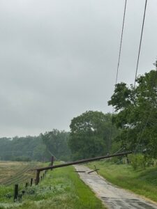
MidAmerican Energy photo
(Radio Iowa) – Powerful thunderstorms with intense winds and a possible tornado thrashed across the Davenport area last (Tuesday) night, toppling trees and snapping several dozen utility poles. There are no reports of any serious injuries. MidAmerican Energy spokesman Geoff Greenwood says many thousands of homes and businesses across the Quad Cities were left in the dark. “At its peak, we had about 21,800 customers out, mostly in Illinois, though we had some on the Iowa side and we restored most of those customers overnight,” Greenwood says, “however, we still have a few thousand that we’re working on and those are the customers where it’s going to take a little bit more time.” That’s because the areas are hard to access, like in hilly backyards that are full of trees.

MidAmerican Energy photo
While much of Iowa just had showers on Tuesday, the storms gained strength as they approached the Quad Cities. “We just had very strong winds that went through the area. In some cases, they just felled trees and the trees took down our power poles and took down the lines,” Greenwood says. “We have counted at least 40 poles that are down and that count is still growing.” Given the extent of the damage and outages, the utility dispatched crews from Des Moines, Fort Dodge, Waterloo and Iowa City to join crews from the Davenport area in the response. “We had more than 75 line workers out in the field overnight, along with more than 70 tree crews,” Greenwood says. “In some cases, we needed those tree crews to clear areas to enable our line crews to do their work safely.”
Most Quad Cities customers had their power restored quickly, though others will need to be patient.”We’re working really hard to get those customers on,” Greenwood says. “We expect to have most of them restored by some time today. It could be into tonight, so most customers will be back throughout the day.”
The Davenport office of the National Weather Service had reports of more than three inches of rainfall in some areas as well as wind gusts of up to 72 miles an hour.
Atlantic (KJAN), .59″
Atlantic (7 miles N/NE), .54″
Council Bluffs, .38″
8.3 miles W/NW of Creston, .78″
Earling, .64″
Elk Horn, .47″
Hastings, .74″
Imogene, .89″
Manning, 1.05″
Massena, .69″
Missouri Valley, .48″
Sac City, .27″
Thurman, .95″
Today: An AIR QUALITY ALERT (for intermittent heavy smoke from the Canadian wildfires) remains in effect through 6-a.m. Thursday. Mostly sunny. High near 76. Winds E/NE @ 5-10 mph.
Tonight: Partly cloudy, with a low around 54.
Tomorrow: Mostly cloudy w/a slight chance of showers. A high near 72. E @ 5-10 mph.
Tom. Night: Cloudy w/a 40% chance of showers and thunderstorms. Low around 56.
Friday: A 30% chance of showers & thunderstorms, otherwise partly sunny with a high near 73.
Fri. Night: A slight chance of thunderstorms in the evening; Partly cloudy, with a low around 54.
Saturday: Mostly sunny w/a slight chance of showers & thunderstorms in the afternoon. A high near 77.
Tuesday’s High in Atlantic was 71. The Low this morning was 46. We received .59″ rain yesterday at the KJAN studios. Last year on this date, the High in Atlantic was 84 & the Low was 52. The Record High for June 4th in Atlantic was 96 in 1914, & the Record Low was 31 in 1945. Sunrise: 5:47. Sunset: 8:49.
The Iowa DNR has issued an Air Quality Alert for all of Iowa through 6 AM Thursday. Intermittent heavy smoke is expected to impact most of Iowa over the next few days at levels considered unhealthy for sensitive groups or even unhealthy for healthy individuals. Sensitive groups include people with respiratory illness or heart disease, children, teenagers, the elderly, and outdoor workers.
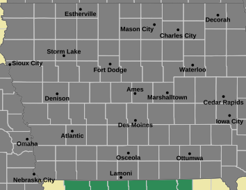
Air Quality Alert for all of Iowa
The DNR recommends that people avoid long or intense outdoor activities and take frequent breaks until the air quality improves.
*Official NWS report; **area media reports
Atlantic (KJAN), .21″
Atlantic (7.1 miles N/NE), .43”*
Anita, .27″
Audubon, 1.10″
Carroll, .67″*
Corning, .10″
Council Bluffs (2 reports), [average] 1.25″*
Creston (8.3 miles W/NW), Trace*
Cumberland, .10″
Earling, 1.34″*
Elk Horn, .53”*
Greenfield, .15″
Griswold, .10″
Guthrie Center, .15″
Harlan, .20″
Hastings, .14″*
Logan, 1.04″*
Massena, .08″*
Missouri Valley, .68″*
Oakland, .20″
Pacific Junction, (3.9 miles N), .51″
Red Oak, .10″
Thurman, .14″*
Woodbine, .74″*
Today: Showers & thunderstorms. Temperature falling to around 59 by 5pm. Winds South this morning becoming Northerly this afternoon, at 10-to 25-mph. New rainfall amounts between a half and three quarters of an inch possible.
Tonight: Showers & thunderstorms ending. Gradually becoming partly cloudy. Low around 49. Winds N @ 10-20 mph. New precipitation amounts of less than a tenth of an inch, except higher amounts possible in thunderstorms.
Tomorrow: Sunny, with a high near 75. N/NW winds 5-10 becoming E/NE in the afternoon.
Tom. Night: Partly cloudy, with a low around 54. .
Thursday: A 40% chance of showers. Mostly cloudy, with a high near 72.
Thu. Night: A 30% chance of showers & thunderstorms. Low around 55.
Friday: Partly sunny, with a high near 73.
Monday’s High in Atlantic was 91. The Low was 64. We received .21″ of rain this morning (as of 7-a.m./24-hour total). Last year on this date (June 3rd), the High in Atlantic was 85 & the Low was 63. The All-time Record High for June 3rd was 94 in 2020, & the Record Low was 32 in 19697. Sunrise: 5:47. Sunset: 8:48.


