
Today: Mostly sunny. High near 88. S/SE winds 10-20 mph.
Tonight: Partly cloudy, with a low around 63. South wind 5 to 10 mph.
Friday: Partly sunny, with a high near 86. South wind 5 to 10 mph.
Friday Night: Partly cloudy, with a low around 64.
Saturday: Mostly sunny w/a 20% chance of afternoon showers & thunderstorms. A high near 90.
Sat. Night: A 30% chance of showers & thunderstorms, mainly after midnight. Low around 66.
Sunday: Partly sunny w/a 30% chance of showers and thunderstorms. A high near 88.
Sunday Night: A 40% chance of showers and thunderstorms. Low around 66.
Wednesday’s High in Atlantic was 94. The Low this morning, was 59. Last year on this date, the High in Atlantic was 88 & the Low was 68. The Record High for June 12th in Atlantic was 95 in 1892. The Record Low was 38 in 1903. Sunrise: 5:45. Sunset: 8:54.
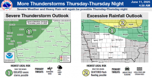
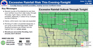
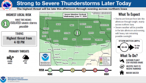
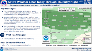
(4:48-a.m. report) – The National Weather Service in Des Moines says there is the potential for severe weather today over most of Northern, and parts of Western & Central, Iowa. Severe thunderstorms and heavy rainfall are the main features of any storms that form. The primary severe thunderstorm threats will be large hail and strong winds. The storms should begin to form late this afternoon, and continue at intervals through Thursday night.
Additional severe storm specific information can be found at https://www.weather.gov/dmx/dsssevere. The NWS will update the potential for severe storms this evening, unless earlier warranted.
Today: Sunny, with a high near 92. South southwest wind 5 to 15 mph, with gusts to near 20 mph.
Tonight: Partly cloudy, with a low around 64. South wind 5 to 10 mph.
Tomorrow: A slight chance of showers &thunderstorms after noon, otherwise mostly sunny. High near 89. S @ 10-20mph.
Tom. Night: Mo. Cldy w/a slight chance of showers & thunderstorms late. Low 65.
Friday: P/Sunny w/a 30% chance of showers & thunderstorms after 1pm. High near 86.
Fri. Night: P/Cldy w/a slight chance of showers or thunderstorms. Low around 61
Saturday: Mostly sunny, with a high near 83.
Tuesday’s High in Atlantic was 87. The Low was 49. Last year on this date, the High in Atlantic was 90 & the Low was 61. The Record High for June 11th in Atlantic was 99 in 1892. The Record Low was 36 in 1903. Sunrise: 5:45. Sunset: 8:53.
Today: Sunny, with a high near 85. Light southwest wind becoming west southwest 5 to 10 mph.
Tonight: Mostly clear, with a low around 60. South southwest wind around 10 mph.
Tomorrow: Mostly sunny w/a slight percent chance of late afternoon showers & thunderstorms. A high near 92. South southwest wind 5 to 15 mph.
Tom. Night: Mostly cloudy w/a 50% chance of showers and thunderstorms. A low around 64. .
Thursday: A 50% chance of showers & afternoon thunderstorms, otherwise mostly sunny. High near 86. .
Thu. Night: A 50% chance of showers and thunderstorms. Low around 65.
Friday: Partly sunny w/a 30% chance of showers and thunderstorms, mainly after 1pm. High near 83.
Monday’s High in Atlantic was 70. Our Low this morning was 45. Last year on this date, the High in Atlantic was 81 & the Low was 51. The Record High for June 10th in Atlantic was 104 in 1933. The Record Low was 40 in 1966. Sunrise: 5:45. Sunset: 8:53.
Atlantic (KJAN), .08″
Atlantic (7.1 miles N/NE), .02″
Massena, .12″
Clarinda, Creston, Cumberland, Emerson, Griswold & Red Oak, .1″
Corning, .15″
Glenwood, Greenfield, Oakland & Shenandoah, .05″
Today: Partly sunny & breezy, with a high near 72. Winds NW @ 10-20 mph w/gusts to near 30 this afternoon.
Tonight: Partly cloudy, with a low around 51.
Tomorrow: Sunny, with a high near 86. Calm wind becoming west 5 to 10 mph in the morning.
Tom. Night: Clear, with a low around 59.
Wednesday: Sunny, with a high near 92.
Wed. Night: Partly cloudy w/a 40% chance of showers and thunderstorms. A low around 64.
Thursday: A 40% chance of showers & thunderstorms, otherwise mostly sunny, with a high near 85.
Sunday’s High in Atlantic was 69. The Low was 54. We received .08″ rain at KJAN, Sunday. Last year on this date, the High in Atlantic was 81 & the Low was 47. The Record High for June 9th in Atlantic was 101 in 1985. The Record Low was 38 in 1915. Sunrise: 5:46. Sunset: 8:52.
Atlantic (KJAN), .16″*
Anita, .2″
Audubon, .15″
Clarinda, 1.35″
Corning, .2″
Creston, .07″*
Cumberland, .35″
Emerson, .15″
Glenwood, .1″
Greenfield, .3″
Guthrie Center, .2″
Hastings, .05″*
Imogene, .65″*
Massena, .38″*
Oakland, .15″
New Market, .69″*
Pacific Junction, .09″*
Red Oak, .3″
Shenandoah, .55″
Sidney, .38″*
Stanton, .15″
Thurman, .38″*
Today: A 50% chance of showers. Areas of Canadian wildfire smoke. A high near 69. Winds W/SW @ 10-20 mph.
Tonight: Areas of smoke through early Monday morning, otherwise mostly clear. Low around 51. W/SW @ 10-20 mph.
Monday: Mostly sunny & breezy, with a high near 73. Winds NW @ 10-20 mph w/gusts to near 30.
Monday Night: Mostly clear, with a low around 51.
Tuesday: Sunny, with a high near 83. Winds W @ 5-10.
Tuesday Night: Clear, with a low around 58.
Wednesday: Sunny, with a high near 89.
Saturday’s High in Atlantic was 78. The Low was 61. We received .16″ rain at KJAN, Saturday. Last year on this date, the High in Atlantic was 79 & the Low was 53. The Record High for June 8th in Atlantic was 102 in 1985. The Record Low was 38 in 1930. Sunrise: 5:46. Sunset: 8:52.
Today: A 40 percent chance of showers and thunderstorms, mainly before 5pm. Cloudy, then gradually becoming mostly sunny, with a high near 74. Calm wind becoming south 5 to 7 mph in the afternoon. New rainfall amounts between a tenth and quarter of an inch, except higher amounts possible in thunderstorms.
Tonight: Partly cloudy, with a low around 57. South wind 3 to 6 mph.
Sunday: A slight chance of showers and thunderstorms. Mostly sunny, with a high near 73. Northwest wind 8 to 15 mph, with gusts as high as 22 mph. Chance of precipitation is 20%.
Sunday Night: Mostly clear, with a low around 51. West southwest wind 6 to 10 mph.
Monday: Sunny, with a high near 73. Breezy, with a west northwest wind 8 to 18 mph, with gusts as high as 25 mph.
Monday Night: Mostly clear, with a low around 51.
Tuesday: Sunny, with a high near 80.
Friday’s High in Atlantic was 79. The Low was 61. Last year on this date, the High in Atlantic was 88 & the Low was 52. The Record High for June 7th in Atlantic was 98 in 1934, & 2011. The Record Low was 36 in 1894. Sunrise: 5:46. Sunset: 8:51.
Atlantic (KJAN), Trace
Council Bluffs, .04″
Earling, .02″
Elk Horn, .03″
Massena, Trace
Missouri Valley, .04″
Pacific Junction, .03″
Persia, .02″
Sac City, .10″
Thurman, .01″


