
Today: Mostly cloudy w/a 50% chance of showers & thunderstorms. Some severe storms are possible today & tonight, with the main threat being damaging winds and hail. A high near 82. Winds becoming S/SW @ 5-10 mph. New rainfall amounts between a quarter and half of an inch possible.
Tonight: Showers and thunderstorms likely, mainly before 10pm. Low around 63. New rainfall amounts between a quarter and half of an inch possible.
Tomorrow: A 50% chance of showers & thunderstorms, mainly before 1pm; Gradually becoming mostly sunny. High 78. Winds N @ 10-20 mph. New rainfall amounts between a quarter and half of an inch possible.
Thursday: Sunny, with a high near 87.
Thu. Night: A 20% chance of showers and thunderstorms after midnight. Low around 68.
Friday: Sunny & windy, with a high near 94.
Monday’s High in Atlantic was 88. The Low was 61. We received .43″ rain Monday night at KJAN. Last year on this date, the High in Atlantic was 91 & the Low was 68. The Record High for June 17th in Atlantic was 102 in 1918 & 2021. The Record Low was 40 in 1974. Sunrise: 5:45. Sunset: 8:56.
9:10-p.m. Numerous medium-to-large size trees down in Atlantic; Hail and heavy rain/wind – near zero visibility at times – lasted about 10-minutes (Cass Co. EMA/Law enforcement & KJAN observation reports); Damage observed at Hy-Vee & Walmart, and near KJAN.

Flag pole snapped by the Atlantic Welcome sign near KJAN (Courtesy Ann Stangl). 6-16-25

Photo courtesy Kristin Harrold, of Lewis. Looking toward Atlantic during the storm on 6-16-25
9:03-p.m. 62 mph gust of wind NE of Tabor recorded at a personal weather station.
7:51-p.m. 60 mph gust of wind recorded at a personal weather station near Coon Rapids.
(Radio Iowa) – Forecasters say most of Iowa faces the risk of severe weather late this afternoon and tonight, with hail, high winds, heavy rain and tornadoes all possible, especially for western, northwestern and north-central Iowa. Meteorologist Brooke Hagenhoff, at the National Weather Service, says after a weekend where parts of Iowa saw more than two inches of rainfall, much more moisture is on the way through tomorrow.
“Isolated pockets across the state could see four inches or more, depending on how some of these storms set up, so we are monitoring the potential with these repeated heavy rain events kind of on back-to-back days,” Hagenhoff says. “There may be some potential for flash flooding as well as maybe some rises on area rivers as well.” 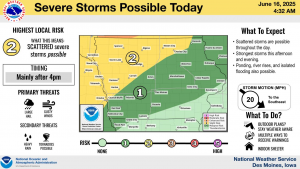
These are the final days of spring, with summer arriving this weekend, and Hagenhoff says the weather is shifting right on schedule. “We’re looking at a return to the 90s as we get towards next week and it’s going to remain muggy,” she says, “so it’s definitely going to feel much more summerlike as we get towards the end of the week.”
Summer officially arrives on Friday at 9:42 pm/Central.
Atlantic (KJAN), .78″ **
Atlantic (7 miles N/NE), .11″**
Massena, .61″**
College Springs, .15″ **
Creston, .37″ **
Council Bluffs, .15″ **
Earling, .15″**
Sac City, .07″ **
New Market, .22**
Anita, .2″
Marne, 1″
Adair, .18″
Harlan, .1″
Red Oak, .14″
Audubon, .18″
** Official report to the National Weather Service. All other totals are reports from area media.
These numbers along with other reports, may be updated once the final results are in from the NWS.
Today: Mostly sunny, with a high near 88. South wind 5 to 15 mph, with gusts as high as 20 mph.
Tonight: Mostly cloudy w/a 40% chance of showers & thunderstorms, mainly after 10pm. Low around 68.
Tomorrow: A 70% chance of showers & thunderstorms, otherwise partly sunny. A high near 85. W-S/SE winds 5-10 mph.
Tom. Night: Showers and possibly a thunderstorm. Low around 63.
Wednesday: Partly sunny w/a 40% chance of showers and thunderstorms. A high near 79.
Thursday: Sunny, with a high near 86.
Sunday’s High in Atlantic was 89. The Low was 66. We received .78″ rain Sunday night. Last year on this date, the High in Atlantic was 91 & the Low was 70. The Record High for June 16th in Atlantic was 103 in 1946. The Record Low was 42 in 1974. Sunrise: 5:45. Sunset: 8:56.
Today: Partly sunny w/a 20% chance of showers & thunderstorms after 10am. A high near 86. South wind 5 to 10 mph.
Tonight: Mostly cloudy w/a 40% chance of showers & thunderstorms. Low around 66. New rainfall amounts between a half and three quarters of an inch possible.
Monday: Mostly sunny w/a 20% chance of showers & thunderstorms before 1pm. A high near 88. S @ 5-10.
Mon. Night: A 50% chance of showers & thunderstorms. Low around 66. New rainfall amounts between a tenth and quarter of an inch, except higher amounts possible in thunderstorms.
Tuesday: A 70% chance of showers & thunderstorms. A high near 84. SE @ 5-10. New rainfall amounts between three quarters and one inch possible.
Tue. Night: Showers and possibly a thunderstorm. Low around 63. New rainfall amounts between a half and three quarters of an inch possible.
Wednesday: A 30% chance of showers & thunderstorms, mainly before 1pm. A high near 78.
Thursday: Sunny, with a high near 85.
Saturday’s High in Atlantic was 90. The Low was 68. Last year on this date, the High in Atlantic was 83 & the Low was 66. The Record High for June 15th in Atlantic was 99 in 1918. The Record Low was 40 in 1906 & 1969. Sunrise: 5:45. Sunset: 8:56.
Today: Mostly sunny, with a high near 88. South wind 5 to 10 mph.
Tonight: Mostly cloudy w/a 20% chance of showers & thunderstorms after midnight. Low around 68.
Tomorrow: Partly sunny w/a 50% chance of showers & thunderstorms. A high near 87. South wind 5 to 10 mph.
Tom. Night: A 40% chance of showers & thunderstorms. Low around 66.
Monday: P/Sunny w/a slight chance of showers and thunderstorms. A high near 88.
Mon. Night: A 60% chance of showers & thunderstorms. A low around 66.
Tuesday: A 60% chance of showers & thunderstorms. A high near 85.
Tue. Night: Showers and possibly a thunderstorm. Low around 64.
Friday’s High in Atlantic was 87. The Low was 62. Last year on this date, the High in Atlantic was 91 & the Low was 63. The Record High for June 14th in Atlantic was 97 in 1987. The Record Low was 41 in 1933. Sunrise: 5:45. Sunset: 8:55.
(Radio Iowa) – Wednesday’s storm that hit Sibley and other areas of northwest Iowa caused damage to crops, trees, buildings and power lines, but Peter Rodgers, a meteorologist at the National Weather Service office in Sioux Falls, says videos of the storm posted online do not show it was a tornado. “What those videos are showing are little swirls and curls on the leading edge of those strong downburst winds and so they certainly have a circulation with them and they appear to be a tornado, but the rotation is at the ground and not connected to an actual nearby thunderstorm,” he says. “We call them gustinadoes.”
Rodgers says wind speeds were between 60 to 80 miles per hour in the storm. Osceola County Emergency Management Director Corey Shearer has surveyed damage in Sibley, Ocheyedan and Allendorf. “Very big diameter branches down, trees down,” he says. “Some hitting houses where siding, roofs, windows damaged.” Kossuth County Emergency Management Coordinator Charissa Mueller was tracking the storm as it passed through Fenton. “They received a quite a bit of marble-sized, pea-sized hail in a quick amount of time resulting in some crop damage there with the corn,” she says. “Looking at Whittemore and Algona, we had a lot of trees down.”

Photo of crop damage by Kossuth County Emergency Management Coordinator Charissa Mueller
In Lyon County, some roofs in Rock Rapids were damaged, in Clay County trees were toppled near Fostoria and in Emmet County the Veterans Memorial in Emmetsburg was damaged as the storm rolled through.
Today: Mostly sunny, with a high near 84. S/SE winds 5-10 mph.
Tonight: Partly cloudy, with a low around 64.
Tomorrow: Sunny, with a high near 89. S/SE winds 5-10 mph.
Tom. Night: Partly cloudy w/a 20% chance of showers & thunderstorms after midnight. Low 66.
Sunday: Partly sunny. A 40% chance of showers & thunderstorms. High near 88.
Sunday Night: Mostly cloudy w/a 40% chance of showers and thunderstorms. Low around 66.
Monday: P/Sunny w/a slight chance of showers and thunderstorms. A high near 89.
Tuesday: P/Sunny w/a 50% chance of showers and thunderstorms. A high near 87.
Thursday’s High in Atlantic was 87. The Low this morning, was 60. Last year on this date, the High in Atlantic was 90 & the Low was 56. The Record High for June 13th in Atlantic was 100 in 2022. The Record Low was 37 in 1906. Sunrise: 5:45. Sunset: 8:54.
(Radio Iowa) – For the first time since last October, parts of Iowa saw high temperatures in the 90s on Wednesday afternoon. Meteorologist Jim Lee, at the National Weather Service, says Des Moines hit 95 degrees and the heat generated a lot of turbulence in the air.“We did have a round of severe thunderstorms across parts of northern and northeastern Iowa. A lot of wind damage, a little bit of hail, in a swath from around Estherville to Waterloo roughly,” Lee says. “We had a lot of reports of trees down, some power lines down, a few places where limbs fell on homes, things like that.”
Lee says the forecast is calling for the chance of more storms later today. “We do think there will be some more scattered thunderstorms this afternoon and evening,” Lee says. “For most of the state, severe weather is unlikely, but there could be some more severe thunderstorms up in the north, more or less the same kind of area as yesterday.”
The extended forecast shows a chance of showers for wide sections of Iowa both Saturday and Sunday.


