
Today: Sunny, hot & windy, with a high near 96. Extreme Heat Warning in effect until 9-p.m. Sunday. Heat index values as high as 104. Winds S/SW @ 23-28 mph. Gusts up to 39 mph
Tonight: Mostly clear & windy, with a low around 76. Winds S @ 21-23 mph.Gusts up to 37.
Tomorrow: Sunny, hot & windy. A high near 98. Heat index values as high as 102. SW winds 22-26 mph with gust as high as 36.
Tom. Night: Mostly clear & windy. Low around 75. S/SW @ 18-23 mph. Gusts up to 36.
Monday: Showers likely and a possible thunderstorm after 1 p.m Mostly sunny and breezy with a high near 91. S/SW winds 13-16 mph becoming W/NW in the afternoon. Chance of precipitation is 60%
Monday Night: Showers and a possible thunderstorm with a low around 67. 90% chance of precipitation with 2 inches of new rainfall possible.
Tuesday: Showers likely and a possible thunderstorm. Mostly cloudy with a high near 83. 70% chance of precipitation.
Friday’s High in Atlantic was 96. The Low was 74. Last year on this date, the High in Atlantic was 84 and the Low was 66. The Record High for June 2st in Atlantic was 101 in 1988. The Record Low was 38 in 1902. Sunrise: 5:46. Sunset: 8:57.
(Radio Iowa) – Recent rainstorms are helping to improve Iowa’s soil conditions, though only about a third of the state is completely drought-free. The new map from the U-S Drought Monitor shows the amount of the state in abnormally dry or drought conditions has fallen in the past week from around 80 to just under 70 percent. State climatologist Justin Glisan says southwest Iowa remains a “problem child” with above average temperatures and below average rainfall.
“One of the driest parts of the state has been that southwest corner of Iowa,” Glisan says. “As we shifted into May, we did see a slightly more active weather pattern, but actually it was the first May since 2010 without a tornado reported. So, the lack of severe weather — that’s where we see drought and dryness across the state.” While spring officially ends later today (Friday), Glisan says meteorological summer started June 1st. Over the course of March, April and May, he says Iowa was two-and-a-half degrees warmer than normal, and two inches below normal for precipitation. Though Iowa broke a four-year drought in May of last year, Glisan says dry conditions are still impacting water levels. 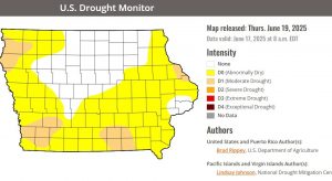
“If you go back four to five years, most stations across the state are still missing out on about a year’s worth of precipitation,” he says. “So, this has impacts on aquifers, which we pull water out of, but also well fields and other water supply sources.” The new drought monitor map shows pockets of “moderate” drought in all four corners of the state. As corn pollination and detassling season approaches, Glisan says Iowa’s crops may become stressed.
“With those windy conditions and high temperatures, that’s where we can exacerbate dryness across the surface,” Glisan says. “So, we’re extracting soil moisture — that topsoil moisture — first. Plus, vegetative demand is increasing with corn and beans, as well. So, this is where we can get into a period of time of rapid drying at the surface.”
Glisan says that could cause stress in corn and soybean fields. On the positive side, he says most of the state remains in a lull in terms of severe weather.
(National Weather Service) – Severe thunderstorm warnings were issued for some counties in western Iowa early today (Friday). The storms brought mainly strong wind and some brief, heavy rain. The National Weather Service in Omaha reported the following gusts of wind were observed at some person weather stations (PWS):
12:55-a.m., 2 miles W of Red Oak (Montgomery Co.), 55 mph gust recorded at the Red Oak Airport (AWOS).
1:16-a.m., 3 miles SE of Pacific Junction, PWS recorded wind gust of 66 mph.
1:24-a.m., 4 miles N/NE of Tabor (Mills Co.), wind gust of 76 mph.
1:34-a.m., 3 miles S. of Malvern (Mills Co.), PWS recorded wind gust of 60 mph.
1:40-a.m., 4 miles S/SW of Hastings (Mills County), PWS wind gust of 62 mph.
1:57-a.m., 4-miles NE of Essex (Page County), a PWS recorded a 72 mph wind gust.
2-a.m., 7-miles NE of Emerson (Montgomery County), a thunderstorm wind gust of 58 mph
3:04-a.m., Bedford (Taylor County), 57 mph gust at a PWS.
Today: Sunny, hot & windy, with a high near 96. Extreme Heat Warning in effect from Noon today until 9-p.m. Sunday. Heat index values as high as 103. Winds S/SW @ 15-35 mph. Heat index values this weekend of 105-110 degrees.
Tonight: Mostly clear & windy, with a low around 76. Winds S @ 20-35 mph.
Tomorrow: Sunny, hot & windy. A high near 98. Heat index values as high as 103. SW winds 20-to near 40 mph.
Tom. Night: Mostly clear & windy. Low around 76. S @ 20-30 mph.
Sunday: Sunny, hot & windy, with a high near 97.
Sunday Night: A slight chance of showers & thunderstorms. A low around 75.
Monday: A 50% chance of afternoon showers & thunderstorms, otherwise mostly sunny, with a high near 93.
Thursday’s High in Atlantic was 88. The Low was 58. Last year on this date, the High in Atlantic was 84 & the Low was 66. The Record High for June 20th in Atlantic was 101 in 1937 & 1988. The Record Low was 40 in 1961. Sunrise: 5:46. Sunset: 8:57.
Atlantic (KJAN), .03″**
Atlantic (7.1 miles N/NE), Trace of rain **
Elk Horn, .07″**
Massena, .48″**
Creston (8.3 miles W/NW), .05″**
Hastings, .05″**
**= Official National Weather Service reporting site
Other reported rainfall totals include:
Today: Sunny, with a high near 87. Light west southwest wind increasing to 5 to 10 mph this morning.
Tonight: A 20% chance of showers & thunderstorms after midnight, otherwise mostly clear. Low around 69. Winds S @ 10-25 mph.
Tomorrow: Sunny & windy w/a high near 96. S @ 15-35 mph.
Tom. Night: Mostly clear & windy, with a low around 76.
Saturday: Sunny and hot, with a high near 97. Windy. Extreme Heat Watch in effect from Sat. afternoon (12-p.m.) through Sunday evening (9-p.m.) for all of Iowa for heat index values of 105-to 110-degrees.
Sunday: Sunny & windy, with a high near 96.
Monday: Mostly sunny w/a 60% chance of showers & some afternoon thunderstorms. A high near 92.
Wednesday’s High in Atlantic was 79. The Low this morning was 56. We received .03″ rain Wednesday evening in Atlantic, at KJAN. Last year on this date, the High in Atlantic was 74 & the Low was 65. The Record High for June 19th in Atlantic was 104 in 1974. The Record Low was 42 in 1900. Sunrise: 5:45. Sunset: 8:56.
(Radio Iowa) – The calendar says summer arrives on Friday and forecasters say the steamy, hot weather of the season will also arrive in Iowa on Friday, right on time. Meteorologist Donna Dubberke, at the National Weather Service, says Iowans should try to enjoy these final days of spring.
“By the time we get to Friday, we’re going to be into a warming trend,” Dubberke says. “We’re looking at heat indices pushing 100-degrees on Friday and then Saturday, it looks downright hot with a heat index over 105, it’s going to be hot and muggy, and then still hot on Sunday.” 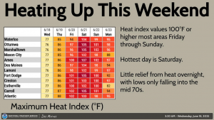
She says the long-range forecast shows high temperatures are expected to fall back in the 80s by next Tuesday.
Today: Mostly cloudy w/a 50% chance of showers & thunderstorms, mainly after noon. A high near 79. NW winds becoming N/NW at 5-10 mph. Gusty winds & locally heavy rainfall are possible, with the potential for flash flooding & river rises in some of the listening area.
Tonight: Mostly clear, with a low around 59.
Tomorrow: Sunny, with a high near 89. West southwest wind 5 to 10 mph.
Tom. Night: Mo. Cloudy w/a slight chance of showers & thunderstorms. A low around 68.
Friday: A slight chance of thunderstorms before 7am, otherwise sunny, hot & windy, with a high near 96.
Friday Night: Mostly clear & windy, with a low around 76.
Saturday: Sunny, hot & windy. A high near 98.
Tuesday’s High in Atlantic was 81. The Low this morning, was 65. Last year on this date, the High in Atlantic was 88 & the Low was 65. The Record High for June 18th in Atlantic was 98 in 1910. The Record Low was 46 in 1974 & 2000. Sunrise: 5:45. Sunset: 8:56.
Atlantic (KJAN), .43″ **
Atlantic (7.1 miles N/NE), .2″ **
Creston, .27″ (8.3 miles N/NW) **
Elk Horn, .36″ **
Massena, .27″
Missouri Valley, .11″ **
** Official NWS sites
Other reports:
Anita, .3″
Audubon, 1.3″
Carroll, 1.9″
Clarinda & Harlan, 1″
Creston, .95″
Corning, .15″
Cumberland and Greenfield, 1.1″
Emerson, 1.4″
Glenwood, 1.35″
Griswold, 1.95″
Guthrie Center, 1.7″
Marne, .5″
Oakland, 1.4″
Shenandoah, 1.15″
(Atlantic, Iowa) – Severe storms popped-up and caused damage in Atlantic, Monday night. The storm which occurred with little warning until it hit, and lasted for about 10-minutes or so, packed quite a whollop.It brought high wind, pea-size hail and heavy rain that caused near-zero visibility at times, according to law enforcement reports. It also caused medium-to-large size trees or tree limbs to fall.
At least two streets were blocked by tree debris Monday night, according to dispatch reports from the Cass County Communications Center. KJAN listeners/social media followers, sent us pictures of damage near the Atlantic Hy-Vee and Walmart stores, the welcome sign off of Olive Street just south of the KJAN studios. One follower sent a picture of the storm over Atlantic, from a City of Lewis perspective. (You can view those pictures on in the Storm Report information on our Weather Page).

Photo courtesy Kristin Harold, of Lewis. Looking toward Atlantic during the storm on 6-16-25
The extent of the damage was expected to become clear as sunrise occurred.
Elsewhere, in Omaha, the College World Series game between LSU and UCLA was suspended Monday night. KETV reports Fans were asked to leave their seats and take shelter in the concourse with a severe thunderstorm warning for the Omaha area. The game will resume at 10 a.m. today (Tuesday). Gates will open at 9 a.m., with the box office opening at 8 a.m. Tuesday.


