
(Radio Iowa) – The latest Drought Monitor shows continued improvement in the state following more rain. The monitor shows 45 percent of the state has no drought conditions, that’s up from 31 percent last week. Just 20 percent of the state was without drought at the start of this year.
Around nine percent of the state has moderate drought, down from around 12 percent. Nearly 55 percent of the state is listed as abnormally dry, which is down from nearly 69 percent last week. The driest conditions are on the east and western edges of the state, with the southeast and south-central areas with the most counties with moderate or abnormally dry conditions.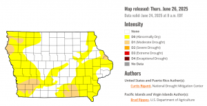
The data for the report is taken through Tuesday, and does not show the impact of the most recent rains.
(Radio Iowa) – Plenty of thunderstorms have rolled over Iowa lately and the experts at the National Weather Service are offering some reminders about the dangers of lightning. Meteorologist Ashley Bury says it’s a wise move to stay “weather aware,” especially when potentially severe storms may be moving in.
“Make sure that you have at least some sort of way to keep an eye on radar, just seeing if there’s any storms on the way, or if there’s anything at least expected,” Bury says. “Later on in the day, if you’re going to do something, make sure that you have an option or multiple options to find shelter.” In 2024, there were no reports of any lightning injuries in Iowa. Studies find there are about 25-million cloud-to-ground lightning strikes every year nationwide, while lightning kills an average of 51 people each year in the U-S.
Bury says most Iowans have a weather app on their phones that will help them to stay vigilant. “Keeping that awareness up is definitely very important and just to make sure that you’re not staying outside, don’t go under a tree. If there’s any lightning nearby, you don’t want to get under one of those because that actually attracts lightning,” Bury says. “Or the water, that’s another thing, too. You don’t want to be in the water as well.” 
Other tips include: Don’t use corded phones. Stay away from windows and doors. Don’t touch electrical equipment or cords. Avoid touching metal plumbing. Also, water inside a house is a good conductor of electricity, so don’t wash your hands or dishes, take a shower or bath, or do laundry, during a thunderstorm.
The Weather Service says only about 10% of people who are struck by lightning die. The other 90% must cope with varying degrees of discomfort and disability, sometimes for the rest of their lives.
Today: Partly cloudy to cloudy w/showers & thunderstorms, mainly this afternoon. A high near 84. Winds S/SW @ 5-15 mph w/gusts to near 25. New rainfall amounts between a half and three quarters of an inch possible.
Tonight: A 50% chance of showers & thunderstorms, mainly before 9pm. A low around 64. W/NW winds 5-10 becoming calm after midnight. New precipitation amounts between a tenth and quarter of an inch, except higher amounts possible in thunderstorms.
Tomorrow: Mostly cloudy early, then gradually becoming sunny. A high near 85. Winds light and variable.
Tom. Night: Mostly clear, with a low around 67.
Saturday: Sunny, with a high near 91.
Sat. Night: A slight chance of showers & thunderstorms after midnight. Partly cloudy, with a low around 71.
Sunday: A 50% chance of afternoon showers & thunderstorms. A high near 91.
Sunday Night: A 60% chance of showers & thunderstorms through midnight. Low around 66.
Monday: Mostly sunny, with a high near 85.
Wednesday’s high in Atlantic was 88. The Low was 69. Last year on this date, the High in Atlantic was 88 and the Low was 61. The Record High for June 26th was 103 in 1934 & 1936. The Record Low was 43 in 1902. Sunrise: 5:47; Sunset: 8:58.
Official reports from the National Weather Service cooperative observers:
Atlantic (KJAN), 3.93″
Atlantic (7.1 miles N/NE), 4.21″
College Springs, .94″
Creston (8.3 miles W/NW), 2.46″
Elk Horn, 1.92″
Massena, 5.57″
Shenandoah, 1.1″
[Amounts will be updated]
Unofficial reports (Those submitted to area media or via social media):
Adair, 3.3″
Anita, 2.95″
West of Atlantic, 2.25″
SE of Bridgewater, 5.7″
Clarinda, 1.2″
Corning, 1.15″
Emerson, .65″
Glenwood, .75″
Griswold, 1″
Greenfield, 2.4″
Guthrie Center, 2.6″
Harlan, 1.55- 2.0″ (2 separate reports)
Lenox, .8″
Marne, 2.75″
Neola, 1.3″
Oakland, 1.55″
Red Oak, .7″
Today: Cloudy through mid-morning w/showers & thunderstorms. Gradually clearing. A high near 87. Winds S @ 10-20.
Tonight: Partly cloudy w/a 40% chance of showers & thunderstorms. A low around 70.
Tomorrow: An 80% chance of showers & thunderstorms. High near 85. S/SW winds 10-20 becoming westerly.
Tom. Night: A 50% chance of showers & thunderstorms. Low around 66.
Friday: Partly sunny, with a high near 86.
Saturday: A slight chance of afternoon showers & thunderstorms, otherwise mostly sunny, with a high near 91.
Sunday: Partly sunny w/a 50% chance of showers and thunderstorms. High around 89.
Tuesday’s high in Atlantic was 80. The Low was 68. We received 3.93″ of rain over the past 24-hours (ending at 7-a.m. today). Last year on this date, the High in Atlantic was 94 and the Low was 66. The Record High for June 25th was 106 in 1934 & 1937. The Record Low was 40 in 2004. Sunrise: 5:47; Sunset: 8:58.
Rainfall:
Atlantic (KJAN), 1.42″ (at 7-a.m.) still raining
Atlantic (7.1 miles N/NE), .86″
Carroll, .25″
near Creston, 2.24″
Council Bluffs, .94″ to .97 (2 sites)
Cromwell, 2.85″
Dunlap (Crawford County), .15″
Earling, .51″
Elk Horn. .26″
Near Ellston (in Ringgold County), 6.16″ (as of 4-a.m.) – still raining [PWS]
Hastings, 1.27″
Imogene, 1.53″
Kirkman, .44″
Massena, 1.33″
Missouri Valley, 1.23″-1.72″
Mondamin, 1.01″
Oakland, 1.31″
Persia, 2.2″
New Markert (Taylor County), 1.96″
Other (Unofficial) reports (relayed to area media, or from the public to KJAN):
3 miles east of Afton, 3.5″ (as of 6-a.m., 6/24)
Avoca, 2.8″
Audubon, .1.75″ (Sam Kauffman)
Clarinda, 3.7″
Corning, 3.6″
Cumberland, 2.7″
Emerson, 2.3″
Essex, 4+ inches of rain (as of 7-p.m., 6/23) (Personal Weather Station [PWS])
Glenwood, .75″
Greenfield, 3.8″
Griswold, 1″
Guthrie Center, .7″
Harlan, .25″
Near Lewis, .16″
Oakland, .55″
Orient, 1″
Red Oak, 1.8″
Shenandoah, 3.75″
Stanton, 2.1″
Wiota, 1″
Storm Damage
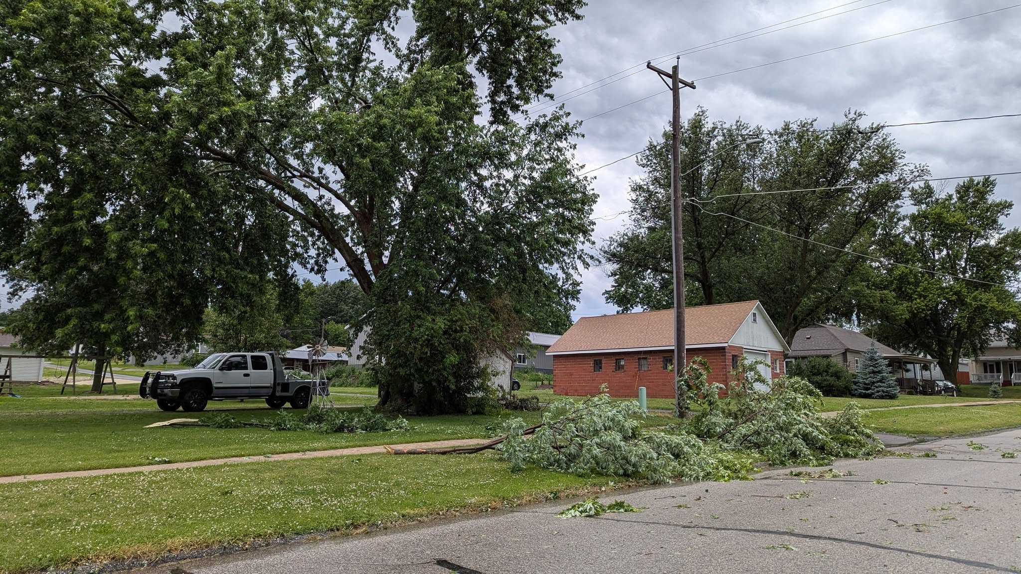
Atlantic (Numerous tree limbs down) – reported by law enforcement and KJAN
59 mph wind gust recorded near Panora 6:12-p.m. 6/23 [PWS]
Today: Mostly cloudy w/a 60% chance of scattered showers & thunderstorms. A high near 80. South wind 5 to 10 mph. New rainfall amounts between a tenth and quarter of an inch, except higher amounts possible in thunderstorms.
Tonight: Showers & thunderstorms. Some of the storms could produce heavy rainfall. Low around 69. New rainfall amounts between 1 and 2 inches possible.
Tomorrow: Showers & occasional thunderstorms. Some of the storms could produce heavy rainfall. High near 89. S/SW @ 10-20. New rainfall amounts between a quarter and half of an inch possible.
Tom. Night: Partly cloudy w/a 50% chance of showers and thunderstorms. A low around 70.
Thursday: A 60% chance of showers & thunderstorms. A high near 88.
Thu. Night: Showers and thunderstorms. A low around 67.
Friday: Partly sunny w/a slight chance of showers and thunderstorms. A high near 89.
Monday’s high in Atlantic was 91. The Low was 67. Rainfall at KJAN (through 4:30-a.m. today) was .73″. Last year on this date, the High in Atlantic was 95 and the Low was 74. The Record High for June 24th was 105 in 1937. The Record Low was 41 in 1961. Sunrise: 5:47; Sunset: 8:57.
(Atlantic, Iowa) – Severe storms erupted across parts of Montgomery, Cass, Adair, Audubon and other area Counties Monday evening. Storms that struck Atlantic at around 5-p.m. brought intense wind and heavy rain, that resulted in street flooding and much tree damage. It appears the eastern side of Atlantic was hardest hit, with a tree at 15th and Olive coming down very near and possibly on a home. (Photos by KJAN News Director Ric Hanson)
Numerous streets were blocked or at the very least littered with tree/branch debris. A severe thunderstorm warning was issued for southeastern Cass County at around 4:15-p.m., Monday. A severe thunderstorm watch was issued for many counties across southwest and central Iowa just at around 4:45-p.m., and a warning for northern Cass County was issued at about the time the storm hit Atlantic.


15th & Olive
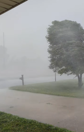
3rd Street Place off of Mulberry (Still frame of the wind/rain)


Today: An 80% chance of showers & thunderstorms. Some of the storms could produce heavy rainfall. High near 89. SW winds @ 10-15 mph this morning will become N/NW this afternoon, gusting up to near 30 mph. New rainfall amounts between a half and three quarters of an inch possible.
Tonight: Showers & possibly a thunderstorm. Some of the storms could produce heavy rainfall. Low around 68. New rainfall amounts between three quarters and one inch possible.
Tomorrow: Showers & some thunderstorms. High near 83. Winds S @ 5-10.
Tom. Night: Showers and some thunderstorms. Low around 69.
Wednesday: A 40% chance of showers & thunderstorms. A high near 89.
Wed. Night: A 60% chance of showers & thunderstorms. Low around 69.
Thursday: A 50% chance of showers and thunderstorms. A high near 88.
Sunday’s High in Atlantic was 94. The Low this morning, was 76. Last year on this date, the High in Atlantic was 88 and the Low was 65. The Record High for June 23rd in Atlantic was 105 in 1937. The Record Low was 44 in 1958. Sunrise: 5:46. Sunset: 8:57.
Today: An Extreme Heat Warning continues until 9-p.m., for dangerously hot conditions; Sunny & windy, with a high near 96. Heat index values as high as 102-to 110-degrees. Winds south @ 20-35 mph.
Tonight: Mostly clear & windy, with a low around 76. S @ 20-35 mph.
Monday: Partly sunny & breezy w/a chance of showers & thunderstorms. High near 90. S/SW-W winds @ 10-25 mph.
Monday Night: Showers and possibly a thunderstorm. Low around 66.
Tuesday: Showers and possibly a thunderstorm. High near 82. South wind 5 to 10 mph.
Tue. Night: Showers & some thunderstorms are possible. Low 69. .
Wednesday: Mostly sunny w/a 40% chance of showers & thunderstorms. A high near 89.
Saturday’s High in Atlantic was 96. The Low this morning, was 77. Last year on this date, the High in Atlantic was 88 and the Low was 63. The Record High for June 22nd in Atlantic was 100 in 1933. The Record Low was 39 in 1972. Sunrise: 5:46. Sunset: 8:57.


