
(Radio Iowa) – Forecasters say Iowa is in for a string of hot, humid and MUGGY days. National Weather Service meteorologist Alexis Jimenez says most of the state will be cooking this afternoon, tomorrow, and likely daily into the weekend. “We’ll see highs probably in the low 90s,” Jimenez says, “but the bigger story will be how hot it will feel because of that humidity.” The combined heat and humidity creates a heat index, what some call a misery index, and it’s expected to feel like it’s at least 105 degrees in many Iowa communities during the afternoons, and in some places, it’ll feel like it’s even hotter.
“Portions of southeast Iowa especially will not only be hot during the day, but even overnight their lows probably won’t get much lower than 75 degrees,” Jimenez says, “so even at night, there won’t be a ton of relief.”
Today’s (Tuesday’s) leg of the statewide bicycle ride RAGBRAI is the longest of the week-long adventure, at nearly 74 miles from Estherville to Forest City. State softball and baseball tournaments are also underway.
Today: Partly sunny w/a 30% chance of showers or thunderstorms. A high near 89. Winds South @ 10-25 mph. ,
Tonight: Other than a slight chance of showers this evening, skies should be mostly clear, with a low around 73. Winds S @ 10-20 mph.
Wednesday: Sunny, with a high near 93. Heat index values as high as 101. South wind 10 to 20 mph.
Wed. Night: A 40% chance of showers & thunderstorms after 1am. A low around 70.
Thursday: Partly sunny w/a 50% chance of showers & thunderstorms, mainly after 1pm. A high near 84.
Thursday Night: Mostly cloudy w/a 30% chance of showers & thunderstorms. A low around 67.
Friday: Partly sunny w/a slight chance of showers & thunderstorms. A high near 86.
Monday’s High in Atlantic was 84. The Low was 70. We received .02″ Monday, in Atlantic (at KJAN). Last year on this date, the High in Atlantic was 85 and the Low was 57. The Record High in Atlantic on July 22nd was 109 in 1901. The Record Low was 45 in 1956. Sunrise today: 6:04; Sunset tonight: 8:47.
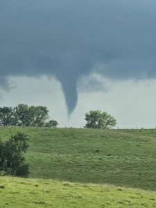
(Atlantic, Iowa) – KJAN listeners and social media followers provided photos of funnel clouds that formed late Sunday evening south of Wiota, near Anita, and northwest of Atlantic. The first reports of a funnel being seen was south of Wiota, at around 5:12-p.m.
A short while later, two separate funnels were spotted near Lake Anita and the Anita Sale Barn. KJAN received several pictures of both phenomenon, referred to by the National Weather Service as “Cold Air funnels.”
A little after 5:30-p.m., the Weather Service sent out a Special Weather Statement advising “Funnel clouds are possible due to current atmospheric conditions. These funnel clouds are typically brief, drop only a few hundred feet from the cloud base, and rarely become a tornado or cause damage.”
They urged persons seeing them, to report their observances to the National Weather Service. Another funnel was observed northwest of Atlantic, just before 6-p.m., Sunday.
There were no confirmed reports of any funnels reaching the ground, and no injuries were r

Ashley Andrew (photo)
eported. Check out the photos in posts on our Facebook page. Here are just a few of the images we received….
Travis moon (photo)

Travis moon (photo)

Leo Dennis (photo)

Callie Marie Chamberlin (phot0)

Chad Frieze (photo)

(Courtesy Kristen Hilpipre-Calhoun)


Today: Mostly cloudy, then gradually becoming sunny, with a high near 87. Heat index values as high as 100. SE wind 10-20 mph.
Tonight: Partly cloudy, with a low around 74. S/SE wind 5 to 10 mph.
Tomorrow: Mostly sunny, with a high near 92. Heat index values as high as 102. S/SE winds 10-25 mph.
Tom. Night: Mostly clear, with a low around 73. South winds 10-20 mph.
Wednesday: Sunny, with a high near 94.
Wed. Night: A 30% chance of showers & thunderstorms late; Partly cloudy, with a low around 70.
Thursday: A 50% chance of showers & thunderstorms, mainly after 1pm; Partly sunny, with a high near 88.
Sunday’s High in Atlantic was 90. The Low was 70. We received .97″ Sunday evening in Atlantic (at KJAN). Last year on this date, the High in Atlantic was 83 and the Low was 56. The Record High in Atlantic on July 21st, was 107 in 1934. The Record Low was 44 in 1894. Sunrise today: 6:03; Sunset tonight: 8:48.
Atlantic (KJAN), .29″ *
Atlantic (7.1 miles N/NE), 1.03″ *
Adair, 5.75″ (as of 6:30-a.m.)
Anita, 2.15″
Audubon, .83″** (Another report said 2.4″)
Brayton, 1.15″
Carroll, 1.35″
Corning, 3.2″
Council Bluffs, .11″*
Creston (8.3 miles W/NW), .34″*
Cromwell (Union County), .06″*
Dunlap, 1.03″*
Earling, 1.54″*
Elk Horn, 1.43″*
Glenwood, .45″
Greenfield, 2″
Guthrie Center, .95″
Harlan, 1.1″
Hastings & Pacific Junction, .05″* each
Kirkman, 1.73″*
Logan, 1.45″*
Marne, .25″
Massena, .61″*
Missouri Valley, 1.04″*
North of Neola, 1.4″
Oakland, .25″ [2.7 miles N/NW]* & .59″ [3.2 miles N/NE] (Two separate reports)
Red Oak, .35″
Schleswig, .68″*
Shenandoah, .35″
Tennant, 1.5″
Thurman, .04″*
*NWS Observer report
**Automated Airport Weather Observation System (AWOS) report
Other reports are those from area media
Today: Partly sunny. A high near 85. East wind around 10 mph.
Tonight: A slight chance of showers and thunderstorms after 10pm. Low around 70. .
Monday: Partly sunny, with a high near 88. Southeast wind 5 to 10 mph.
Monday Night: A chance of showers and thunderstorms after 1am. Low around 72.
Tuesday: Mostly sunny, with a high near 92.
Wednesday: Sunny, with a high near 94.
Thursday: Mostly sunny, with a high near 90.
Saturday’s High in Atlantic was 89. The Low this morning was 70. We received .29″ overnight in Atlantic (at KJAN). Last year on this date, the High in Atlantic was 75 and the Low was 57. The Record High in Atlantic on July 20th, was 109 in 1934. The Record Low was 44 in 1953. Sunrise today: 6:02; Sunset tonight: 8:49.
Today: Partly sunny w/a 40% chance of showers & thunderstorms, mainly after 4pm. A high near 86. Winds South @ around 5 mph this morning switching to the East this afternoon.
Tonight: A 50% chance of showers and thunderstorms. Low around 68.
Sunday: Mostly cloudy w/a slight chance of showers and thunderstorms. A high near 82. East wind 5 to 10 mph.
Sunday Night: A 40% chance of showers and thunderstorms after midnight. Low around 68.
Monday: Partly sunny, with a high near 87. Southeast wind 5 to 10 mph.
Monday Night: Partly cloudy, with a low around 72.
Tuesday: Mostly sunny, with a high near 92.
Friday’s High in Atlantic was 82. The Low was 64. Last year on this date, the High in Atlantic was 78 and the Low was 61. The Record High in Atlantic on July 19th, was 110 in 1934. The Record Low was 47 in 1891 & 1947. Sunrise today: 6:02; Sunset tonight: 8:49.
(Radio Iowa) – The continued rains created another improvement in this week’s U-S Drought Monitor report, with 88 percent of the state showing NO drought conditions. The D-N-R Jessica Reese McIntyre keeps track of the numbers and says “There is still about 25 percent of the state that’s abnormally dry and about two percent of the state that’s in moderate drought.” she says. Iowa had broken out of a three-year drought just about this time last year, and then the new year started out dry and never got better. “Going into the spring while we were getting rain, we weren’t getting a whole lot to kind of overcompensate for that and then just the overall deficit that we have still coming out of that drought,” she says. June started the turnaround that continued into July. McIntyre says northwest Iowa has probably seen one of the biggest turnarounds after seeing a big section of severe drought. 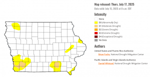
“Seeing them completely remove all of the moderate drought designation really is encouraging, especially for that area, because you know, they’ve just kind of been battered with drier weather compared to the rest of the state,” she says. “And southwest Iowa kind of continues in a very similar dry pattern.” McIntyre issued a “drought watch” for that southwest areas. She says things are a lot better as we head into the last half of July compared to where we were in January. “Most of the state I don’t have any concern as far as drought or abnormally dry conditions. But again, I’ll just can’t kind of keep my eye on that southwest corner and even in the southeast portion of the state, there’s a little bit of moderate drought, so I’ll be keeping my eye on those,” McIntyre says.
She says continued wet condition through July could clear the drought all the way out of the state.
Today: Cloudy, then gradually becoming mostly sunny, with a high near 82. S/SE winds 5-15 w/gusts to near 20 mph.
Tonight: Showers and thunderstorms likely, mainly after midnight. A low around 68. New rainfall amounts between 1 and 2 inches possible.
Tomorrow: A 30% chance of showers & thunderstorms; Partly sunny. High near 85. E/NE @ 5-10 in the afternoon. New rainfall amounts between a quarter and half of an inch possible.
Tom. Night: A 40% chance of showers & thunderstorms, mainly after midnight. Low around 67. New rainfall amounts between a quarter and half of an inch possible.
Sunday: A 30% chance of showers & thunderstorms. High near 82.
Sunday Night: A 40% chance of showers and thunderstorms, mainly after midnight. Low around 69.
Monday: A slight chance of showers & thunderstorms, otherwise mostly sunny, with a high near 88.
Thursday’s High in Atlantic was 77. The Low was 60. Last year on this date, the High in Atlantic was 82 and the Low was 53. The Record High in Atlantic on July 18th, was 107 in 1936. The Record Low was 44 in 1953. Sunrise today: 6:01; Sunset tonight: 8:50.
Today: Partly sunny, with a high near 73. North northeast wind 5 to 10 mph.
Tonight: Increasing clouds, with a low around 59. East wind around 5 mph.
Friday: Mostly cloudy w/a 20% chance of showers & thunderstorms. A high near 81. Southeast wind 5 to 10 mph.
Friday Night: A 60% chance of showers & thunderstorms. with a low around 68. Southeast wind 5 to 10 mph.
Saturday: A slight chance of showers & thunderstorms, otherwise partly sunny, with a high near 85.
Sat. Night: A 40% chance of showers & thunderstorms with a low around 67.
Sunday: Mostly cloudy w/a 30%chance of showers & thunderstorms. A high near 85.
Wednesday’s High in Atlantic was 82. Our Low this morning was 60. Last year on this date, the High in Atlantic was 82 and the Low was 51. The Record High in Atlantic on July 17th, was 109 in 1936. The Record Low was 45 in 1911. Sunrise today: 6:00; Sunset tonight: 8:51.


