
Today: **AIR QUALITY ALERT for wildfire smoke** Areas of smoke. Patchy fog before 8am. Otherwise, mostly sunny, with a high near 75. NE/E winds 5-10 mph.
Tonight: AIR QUALITY ALERT until midnight. Areas of smoke. Partly cloudy, with a low around 55.
Saturday: Partly sunny, with a high near 75. Southeast wind 5 to 10 mph.
Saturday Night: Partly cloudy, with a low around 55.
Sunday: A slight chance of showers and thunderstorms; Partly sunny. A high near 76.
Sunday Night: Mostly cloudy, with a low around 58.
Monday: Partly sunny, with a high near 77.
Thursday’s High in Atlantic was 80. Our Low this morning was 57. Last year on this date, the High in Atlantic was 86 and the Low was 61. The Record High in Atlantic on August 1st was 102 in 1897. The Record Low was 42 in 1898. Sunrise today: 6:14; Sunset tonight: 8:37.
Thursday: Patchy smoke from Arizona and Canadian wildfires drifting into the area this afternoon, otherwise partly sunny. A high near 75. East northeast wind 5 to 10 mph.
Tonight: Patchy smoke. Partly cloudy, with a low around 55. East northeast wind 5 to 10 mph.
Friday: Patchy smoke. Mostly sunny, with a high near 74. Winds E @ 5-10 in the morning.
Friday Night: Partly cloudy, with a low around 56.
Saturday: Partly sunny, with a high near 75.
Saturday Night: Partly cloudy, with a low around 57.
Sunday: A 20% chance of showers and thunderstorms. Mostly cloudy, with a high near 75.
Sunday Night: Mostly cloudy, with a low around 59.
Wednesday’s High in Atlantic was 81. Our Low this morning was 66. Last year on this date, the High in Atlantic was 91 and the Low was 64. The Record High in Atlantic on July 31st was 104 in 1955. The Record Low was 39 in 1971. Sunrise today: 6:14; Sunset tonight: 8:39.
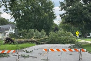
(Radio Iowa) – The experts now say the powerful storm that rolled over Iowa Monday night and into Tuesday was a derecho, an exceptionally long-lasting and damaging wind storm, which some call a land hurricane. Winds in the storm topped off in northwest Iowa at 99 miles an hour, and cleanup in multiple communities statewide may take a week. Meteorologist Alexis Jimenez, at the National Weather Service, says derechos are always designated after the fact.
“That line of storms had moved across much of northern Iowa, and then even sinking into eastern Iowa,” Jimenez says. “So the intensity of seeing 70-plus mile an hour winds for a very long span — at that point, it was hundreds of miles — plus seeing the significant damage that we saw, those all go into factoring if that was a derecho or not.” Iowa was walloped with more powerful storms last (Tuesday) night and into this morning, marking the third straight night of wicked weather. Jimenez says this latest round wasn’t as severe as the previous night, but it did push at least one Iowa city into record territory during what’s usually one of the state’s driest months.
Storm Lake Police photo
“We broke the record for monthly rainfall for July for Des Moines specifically,” Jimenez says. “At least as of 7 o’clock this morning, we’ve had 10.62 inches of rain so far this month, and the previous record was 10.51.” Some areas of the state got three more inches of rainfall overnight, and strong winds again tore through trees, ripping off limbs and knocking out the power to many thousands of homes across Iowa. “We still had some winds that were getting towards severe, 60 miles an hour wind gusts, especially in places like Carroll,” Jimenez says, “and then other sections over by Waterloo, as another line of storms moved through that section of the state.”
Along with three nights in a row of storms, Iowa also had multiple recent days with heat advisories and extreme heat warnings, as heat indices climbed as high as 115 degrees some afternoons. Jimenez says the forecast calls for more pleasant, calm weather ahead with dry conditions and highs the next several days only in the 70s.
Official reports relayed to the National Weather Service
(These reports are from the National Weather Service Offices in Des Moines and Valley, NE)
..TIME...   ...EVENT...      ...CITY LOCATION...     ...LAT.LON...
..DATE...   ....MAG....      ..COUNTY LOCATION..ST.. ...SOURCE....
            ..REMARKS..

0127 AM     Tstm Wnd Gst     1 NNE Bayard            41.87N 94.55W
07/30/2025  M60 MPH          Greene             IA   Public - Personal weather station (PWS)

1220 AM     Tstm Wnd Gst     3 E Westphalia          41.72N 95.34W
07/30/2025  M70 MPH          Shelby             IA   Trained Spotter
            Measured using a handheld anemometer. Had
            consistent 45-55 mph gusts and one gust of
            70 mph.

(Will be updated with additional reports, as available)
Today: Mostly Cloudy. High near 77. North wind 5 to 10 mph.
Tonight: Mostly cloudy w/a 30% chance of showers & thunderstorms. A low around 62. N/NE @ 10-20. New rainfall amounts of less than 1/10 of an inch, except higher amounts possible in thunderstorms.
Tomorrow: Partly sunny, with a high near 75. E/NE winds 10-20 mph.
Tom. Night: Partly cloudy, with a low around 54.
Friday: Mostly sunny, with a high near 74.
Saturday: Mostly sunny, with a high near 75.
Sunday: Partly sunny, with a high near 75.
Tuesday’s High in Atlantic was 93. Our Low this morning (as of 5-a.m.), was 67. Rainfall at KJAN this morning (as of 5-a.m.), was 1.02″. Last year on this date, the High in Atlantic was 89 and the Low was 70. The Record High in Atlantic on July 30th was 102 in 1931 & 1947. The Record Low was 39 in 1971. Sunrise today: 6:13; Sunset tonight: 8:40.
(Radio Iowa) – Strong storms blew into northern and eastern Iowa last night packing winds clocked in some areas from 70 to 100 miles and hour. Sioux County Emergency Management Coordinator Ryan De Kruyf says it hit there around 9:15p-m. “Throughout the county, we’re seeing a lot of tree damage, infrastructure damage, trees that fell on houses, and yeah, it’s ‘s pretty remarkable to drive around and there’s not a lot of areas that don’t have any damage whatsoever,” he says. Some 10-thousand homes were without power and De Kruyf says crews are working to get that restored. “Be cautious and if you don’t have to be out, definitely don’t be out and looking around give the workers that are out there working trying to clear the debris and clear the trees away room to work and so everyone can stay safe,” De Kruyf says.
He says no one was injured in the storm. “We did have a couple houses that some people were trapped in just simply because the exit or doorways were blocked with trees, but we got those people out safely,” De Kruyf says. De Kruyf says many of the toppled tree were large and old. “Orange City specifically, there’s a bunch of pretty old trees that are down and it’s pretty remarkable what this wind event did. It’s it’s snapped a bunch of trees that are quite old, probably ten feet up, and I’ve never seen anything like this,” De Kruyf says.
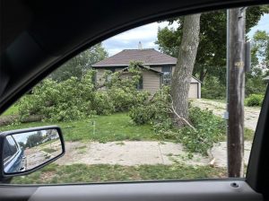
Tree damage in Sioux County. (KSOU photo)
Garner Mayor Tim Schmidt saw the same type of damage in his Hancock County town in north-central Iowa. “It’s quite severe, probably the worst I’ve ever seen,” Schmidt says. He says you couldn’t get anywhere right after the storm hit. “Streets were pretty impassable. I went up to City Hall prior to this storm, otherwise I would have never made it. They’ve been working and hitting the streets cleared. There was a lot of power lines down. Power has been restored on most of the houses,” he says. Schmidt says it’s going to take a lot of work clearing the large number of trees. “I’d say right now, rough estimates 150 to 200. You know you can’t go down a street without being damage,” he says.
Schmidt says the Hancock County Supervisors have declared the county a disaster area.
Today: Sunny, with a high near 93. HEAT ADVISORY from Noon until 8-p.m. Heat index values as high as 106. South wind at around 5 mph.
Tonight: Showers and thunderstorms likely, mainly after midnight. A low around 68. New rainfall amounts between 1 and 2 inches possible.
Tomorrow: Showers likely and possibly a thunderstorm. A high near 77. E/NE winds 5 to 10 mph. New rainfall amounts between three quarters and one inch possible.
Tom. Night: Showers and thunderstorms. A low around 61. New precipitation amounts between a quarter and half of an inch possible.
Thursday: Mostly sunny, with a high near 75.
Thursday Night: Partly cloudy, with a low around 57.
Friday: Mostly sunny, with a high near 74.
Monday’s High in Atlantic was 91. Our Low this morning, 69. Last year on this date, the High in Atlantic was 94 and the Low was 67. The Record High in Atlantic on July 29th was 102 in 1917. The Record Low was 46 in 1952. Sunrise today: 6:12; Sunset tonight: 8:41.
(Radio Iowa) – Scattered damage to trees and power lines is reported across northern and central Iowa after thunderstorms last (Sunday) night and early this morning, some of which packed strong winds. MidAmerican Energy reports the power was out to 30-thousand homes statewide at the peak of the storm. National Weather Service meteorologist Brooke Hagenhoff says those winds are to blame. “Around midnight or so we had some gusts between 60 to 70 miles an hour,” Hagenhoff says. “As the storms have gone south through the early morning hours, we’re still seeing gusts between 40 to 50 mph across central to southern Iowa.” Once these storms pass, Hagenhoff says another muggy July day is ahead.
“The heat builds in really quickly and with that also humidity with all of this rain that’s around,” she says. “We’re looking at the heat index this afternoon, that feels-like temperature between 105 to 110 or even higher, so dangerous heat here settling in.” An Extreme Heat Warning will be posted starting at noon for western Iowa and for the state’s southern half, as heat indices may reach as high as 115 degrees, though Hagenhoff says a cool-down is coming soon.
“Southern Iowa is still going to be pretty steamy on Tuesday, but by Wednesday, the entire state is going to see high temperatures just in the 70s,” she says, “so quite a bit of relief on the way if we can just make it to Wednesday.” No injuries were reported in this morning’s severe weather.
Atlantic (KJAN), .06″ *
7.1 miles N/NE of Atlantic, .19″ *
Anita & Marne, .25″
Audubon, .30″
Carroll, .55″
Clarinda, .20″
Corning, .05″
8.3 miles W/NW of Creston,.22″ *
Cumberland, .10″
2.4 miles SE of Earling, .31″
Elk Horn, .18″ *
Emerson, Griswold & Red Oak, .05″
Glenwood, Greenfield & Guthrie Center, .15″
Harlan & Shenandoah, .10″
Lenox, 1.00″
Massena, .05″
North of Neola, .50″
Oakland, .20″
Persia, .48″ *
Woodbine, .15″ *
(Will be updated as reports become available)* Official National Weather Service reports (All other reports are from the public, and are unofficial observations)


