
Today: Isolated showers and thunderstorms before 9am. A few storms could produce brief, gusty winds; Mostly cloudy, then gradually becoming sunny, with a high near 90. South wind 10 to 15 mph.
Tonight: Partly cloudy, with a low around 73. South southeast wind around 10 mph.
Friday (Day 1 of the Tournament of Champions in Atlantic): Sunny & breezy, with a high near 93. Heat index values as high as 101. Winds South at 10-20 mph w/gusts to near 25.
Friday Night: Partly cloudy, with a low around 74. South wind 10-20 mph.
Saturday (Day 2 of the T-of-C): A slight chance of showers and thunderstorms, otherwise partly sunny, with a high near 86.
Sat. Night: Showers & thunderstorms likely, mainly after midnight. Low around 67.
Sunday (the final day of the T-of-C): Partly sunny w/a 40% chance of showers and thunderstorms. A high near 83.
Wednesday’s High in Atlantic was 85. The Low was 66. We received .95″ Wed. morning at KJAN, and a trace early this morning (a few sprinkles before 5-a.m.). Last year on this date, the High in Atlantic was 83 and the Low was 55. The All-time Record High in Atlantic on Aug. 7th, was 103 in 1937. The Record Low was 45 in 1989. Sunrise is at 6:20; Sunset will be at 8:31.
DES MOINES, Iowa –A devastating weather event, known as a derecho, struck Iowa on August 10, 2020. A line of severe storms extended more than 770 miles for 14 hours. Sustained winds lasted almost an hour over a large swath of Central and Eastern Iowa, causing catastrophic damage to structures, crops and trees. Communities across Iowa were left with a trail of destruction after the storm. Over the past five years, the Iowa Department of Natural Resources (DNR) and Iowa communities have worked towards rebuilding and recovering the tree canopy lost in the destructive storm.
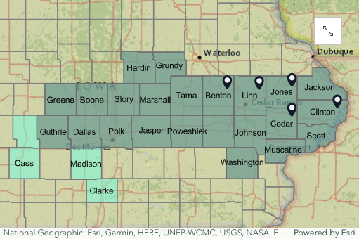
2020 Derecho Counties and FEMA Assistance
DNR’s new “5 Years of Derecho Recovery” interactive map highlights the impact, response and recovery to the August 2020 midwest derecho across Central and Eastern Iowa. Easily browse through stories, maps and videos detailing the severe damage and how Iowa DNR and partnering organizations helped communities recover and replace lost trees.
Explore the interactive map at https://storymaps.arcgis.com/stories/ba98113395d34a03a1b8bd348418bf2c.
Today: Partly sunny w/a 40% chance of showers & thunderstorms, mainly before noon. Some storms could be strong to severe, with damaging winds the primary threat. A high near 85. SW winds 10-20 mph. New rainfall amounts between a quarter and half of an inch possible.
Tonight: Partly cloudy w/a 30% chance of showers & thunderstorms, mainly after midnight. A low around 69.
Tomorrow: Sunny, w/a slight chance of showers & thunderstorms before 7am. A high near 89. Winds S @ 10-20.
Tom. Night: Mostly clear, with a low around 72. South southeast wind around 10 mph, with gusts as high as 18 mph.
Friday: Sunny & breezy, with a high near 92.
Friday Night: A 20% chance of showers & thunderstorms after midnight. Low around 73.
Saturday: A 20% chance of showers & thunderstorms; Partly sunny, with a high near 88.
Tuesday’s High in Atlantic was 81. The Low was 59. Last year on this date, the High in Atlantic was 71 and the Low was 53. The All-time Record High in Atlantic on Aug. 6th, was 105 in 1930. The Record Low was 46 in 1974 & 1997. Sunrise is at 6:19; Sunset will be at 8:32.
(Radio Iowa) – Trees weren’t the only thing knocked down by the derecho that blew through Iowa last week. Gary Knight sells sweet corn at stands in Cedar Rapids and Marion, and tells K-C-R-G T-V he knew some of his corn would have damage. “You know I’m almost afraid to go look at the corn the next morning to see what happened,” Knight says. Over 60 mile and hour winds ripped through the farm, knocking down ten percent of Knight’s sweet corn. “The most vulnerable corn is the corn that’s just ready or ripe, and it has the heavy weight on it. So when it blows down, it’s not going to come back up again,” he says. Some of the corn from those fallen stalks is salvageable, but Knight says he can’t harvest the corn with a machine because of the damage and will have to use the old-fashioned method of picking.
“Go out there by hand, walk through it, bend over, pick them and get them in the wagon. So it’s just a whole lot more work, and hard to find people who’ll go out and do that,” Knight says. The farm lost a total of five acres from the storm that’s now been classified as a derecho. “I’m going to call it ‘monsoon weekend,” Knight says.
That loss of product means some stands are closed for now. As they work to pick up the damage and the crops he said they do still plan to have sweet corn available through September.
Today: Mostly sunny, with a high near 82. E/SE wind becoming S/SE at 5 to 10 mph this morning.
Tonight: A 10% chance of showers & thunderstorms after midnight; Partly cloudy. Low around 64.
Tomorrow: A 30% chance of showers & thunderstorms, mainly before 10am. Mostly cloudy, then gradually becoming sunny, with a high near 86. Winds South @ 10-20 mph.
Tom. Night: A 20% chance of showers & thunderstorms after midnight; Mostly clear, with a low around 69.
Thursday: Mostly sunny, with a high near 88.
Friday: Sunny, with a high near 91. Breezy.
Monday’s High in Atlantic was 79. Our Low this morning was 57. Last year on this date, the High in Atlantic was 94 and the Low was 63. The All-time Record High in Atlantic on Aug. 5th, was 111 in 1918. The Record Low was 42 in 1978. Sunrise is at 6:18; Sunset will be at 8:33.
Today: Partly sunny, with a high near 78. Calm wind becoming southeast 5 to 10 mph this morning.
Tonight: Partly cloudy, with a low around 58. East southeast wind around 5 mph.
Tomorrow: Mostly sunny, with a high near 82. Light southeast wind increasing to 5 to 10 mph in the morning.
Tom. Night: Partly cloudy, with a low around 64. Southeast wind 5 to 10 mph.
Wednesday: Mostly sunny, with a high near 86.
Wed. Night: A 20 percent chance of showers and thunderstorms after 1am. Mostly clear, with a low around 69.
Thursday: Sunny, with a high near 90.
Sunday’s High in Atlantic was 73. Our Low this morning was 56. Last year on this date, the High in Atlantic was 94 and the Low was 65. The All-time Record High in Atlantic on Aug. 4th, was 110 in 1918. The Record Low was 38 in 1978. Sunrise is at 6:17; Sunset will be at 8:35.
Today: Partly sunny, with a high near 77. S/SE winds 5 to 10 mph.
Tonight: Mostly cloudy, with a low around 57.
Monday: Mostly sunny, with a high near 78. Wind becoming S/SE at around 5 mph in the morning.
Monday Night: Mostly clear, with a low around 59.
Tuesday: Sunny, with a high near 83.
Tuesday Night: Partly cloudy, with a low around 64.
Wednesday: A slight chance of showers & thunderstorms, otherwise mostly sunny, with a high near 85.
Saturday’s High in Atlantic was 77. The Low was 53. Last year on this date, the High in Atlantic was 93 and the Low was 64. The Record High in Atlantic on August 3rd was 107 in 1930. The Record Low was 42 in 1907. Sunrise today: 6:15; Sunset tonight: 8:35.
Today: **AIR QUALITY ALERT THRU 8-A.M. SUNDAY**Areas of smoke before 8 am, then areas of smoke after 9 am. Partly sunny, high near 77. Calm wind becoming S/SE 5-9 mph in the morning.
Tonight: Areas of smoke. Partly cloudy, with a low around 57. SE winds 5-7 mph.
Sunday: Mostly sunny, with a high near 76. Southeast wind 5-9 mph.
Sunday Night: Mostly cloudy, with a low around 57. S/SE wind around 6 mph becoming calm in the evening.
Monday: Partly sunny. A high near 78. Calm wind becoming S/SE 5-7 mph in the morning
Monday Night: Partly cloudy, with a low around 60.
Tuesday: Sunny, with a high near 83.
Friday’s High in Atlantic was 75. Our Low this morning was 52. Last year on this date, the High in Atlantic was 90 and the Low was 63. The Record High in Atlantic on August 2nd was 103 in 1930. The Record Low was 42 in 1907.
(Radio Iowa) – State Climatologist Justin Glisan says the drought-busting rains of July pushed the month to near the very top of the state record book
He says it will be a July many people will remember for the big storms.
He says we were another big rain event away from the July record.
Glisan says the early dry months of the year kept 2025 from being another flood year like 1993.

July was the second wettest on record behind 1993. (RI photo)
Glisan says there were two main sources of moisture that led to ample July rain.
Glisan says he gets asked a lot about the so-called “corn sweat” where moisture comes off the 13 million acres of corn in Iowa. He says it is another source of water that leads to rain.
Glisan says the heat dome that set up around the third week of July led to heat indexes in the triple digits, but not record heat.
Glisan says that heat did spawn storms, including the derecho that barreled across the state.
(Atlantic, Iowa) – Weather data for Atlantic during the month of July, 2025 (Compiled here at KJAN – the official National Weather Service reporting site), shows we were three degrees cooler than normal High, and about three-degrees warmer than the normal Low. The average High last month was 83, compared to the 86 degree norm. The average Low was 66, compared to the norm of 63. The warmest day last month was on the 29th, when we topped out at 93 degrees. Our coolest morning was on the 12th, when the thermometer bottomed-out at 55 degrees.
We were a lot soggier last month than is typical for Atlantic. Rainfall amounted to 7.27 inches, which was 2.75-inches above normal.
Looking ahead, we find the average High temperature for August in Atlantic, is typically 83 degrees, while the average Low is 61. Precipitation typically amounts to 3.88-inches. Check back with us during the first week of September 2025, to see how our actual weather data compared to the historical averages for August.


