
Today: Mostly cloudy w/a chance of drizzle this morning. A high near 49. Light and variable wind becoming NE @ 5-10 mph in the afternoon.
Tonight: A chance of drizzle, mainly after 11pm. Mostly cloudy, with a low around 36.
Wednesday: A chance of drizzle before noon, then a chance of rain after noon. Mostly cloudy, with a high near 52. East wind around 5 mph becoming calm in the afternoon.
Wednesday Night: A 40% chance of rain. A low around 35.
Thursday: Mostly sunny, with a high near 63.
Thursday Night: A chance of rain, then showers and possibly a thunderstorm after midnight. Low around 48.
Friday: Showers and possibly a thunderstorm. High near 70. Breezy.
Monday’s High in Atlantic was 49 degrees. The Low was 29. Last year on this date (March 3rd), the High in Atlantic was 60, and the Low was 38. The Record High for this date was 79 in 1983, the record Low was -11 in 2014. Sunrise: 6:53; Sunset: 6:12.
(Atlantic, Iowa) – Weather data for Atlantic during the month of February, 2026 (Compiled here at KJAN – the official National Weather Service reporting site), shows we were 12 degrees warmer than normal for a High, at 48 degrees on average, and 3 degrees warmer than normal for a Low, at 18 degrees. The warmest day last month was 70 on Feb. 9th. Our coolest morning was -7 degrees on the 22nd.
Snowfall amounted 5.3 inches, which was a liquid equivalent of .34,” which was a deficit of .62″ as compared to the historical February average.
Looking ahead, we find the average High temperature for the month of March in Atlantic, is 48 degrees, while the average Low is 26. Precipitation typically amounts to 2.38.”
Check back with us during the first week of April, 2026, to see how our actual weather data compared to the historical averages.
Today: Cloudy, with a high near 46. East wind 5 to 10 mph becoming south southeast in the afternoon.
Tonight: A chance of drizzle, mainly after 1am. Cloudy, with a low around 34. Southeast wind 5 to 10 mph.
Tomorrow: A chance of drizzle. Mostly cloudy, with a high near 50. Light and variable wind becoming NW @ 5-10.
Tom. Night: A 50% chance of rain. A low around 34. New precipitation amounts between 1/10″ & 1/4″ possible.
Wednesday: A 40% chance of rain; Partly sunny. A high near 50. New precipitation < 1/10″.
Wednesday Night: A 40% chance of rain. A low around 35.
Thursday: Sunny, with a high near 64.
Sunday’s High in Atlantic was 37 degrees. The Low was 19. Last year on this date (March 2nd), the High in Atlantic was 50, and the Low was 17. The Record High for this date was 76 in 1992, the record Low was -12 in 2014. Sunrise: 6:54; Sunset: 6:11.
Today: A 20 percent chance of snow after 5pm. Cloudy, with a high near 35. Wind chill values as low as 10. East wind 7 to 13 mph.
Tonight: A 20 percent chance of snow before 3am. Mostly cloudy, with a low around 25. East southeast wind 6 to 9 mph.
Monday: Cloudy, with a high near 45. Southeast wind 6 to 9 mph.
Monday Night: Rain likely, mainly after midnight. Cloudy, with a low around 35. Southeast wind around 6 mph. Chance of precipitation is 70%. New precipitation amounts of less than a tenth of an inch possible.
Tuesday: A chance of rain before noon, then a chance of showers after noon. Mostly cloudy, with a high near 48. East northeast wind 6 to 11 mph. Chance of precipitation is 50%. New precipitation amounts of less than a tenth of an inch possible.
Tuesday Night: A chance of showers, with thunderstorms also possible after 9pm. Mostly cloudy, with a low around 36. Chance of precipitation is 50%. New rainfall amounts between a tenth and quarter of an inch, except higher amounts possible in thunderstorms.
Wednesday: A chance of showers and thunderstorms before noon, then a chance of rain after noon. Mostly cloudy, with a high near 52. Chance of precipitation is 40%.
Today: Mostly cloudy through mid morning, then gradual clearing, with a high near 48. E/NE winds 10-to 20 mph.
Tonight: Increasing clouds, with a low around 17. NE winds around 10 mph. Wind chill values as low as 10.
Sunday: A 30% chance of snow after noon. A high near 32. Winds E @ 10. Wind chill values as low as 5. New snow accumulation of less than a half inch possible.
Sunday Night: A 30% chance of snow, mainly before midnight. A low around 22. New snow accumulation of less than a half inch possible.
Monday: A chance of rain and snow between noon and 3pm, then a chance of rain after 3pm. A high near 40. Winds S @ 5-15 mph w/gusts to near 20 mph. Little or no snow accumulation expected.
Monday Night: Rain. Low around 30. New precipitation amounts between a tenth and quarter of an inch possible.
Tuesday: A 40% chance of rain. Mostly cloudy, with a high near 46.
(Radio Iowa) – Officials say there’s a serious risk of fast-spreading wildfires again today (Friday) as much of Iowa will see unseasonably high temperatures and gusty winds amidst very dry vegetation. Red Flag Warnings are posted for some two dozen counties, including five counties in northwest Iowa, across much of the southern two tiers of counties, and into eastern Iowa. Meteorologist Jim Lee, at the National Weather Service, says an abrupt temperature shift is coming.
“We’ve got temperatures in the 60s in parts of western and southern Iowa, maybe even pushing 70 near the Missouri border,” Lee says, “but then one day later, on Saturday morning, we’re looking for snow across far northern and northeastern Iowa, so rapid changes on the way.” A Winter Weather Advisory is being posted for several northeastern Iowa counties, while Lee says the possibilities of snow will shift to the south for the latter half of the weekend. “We do have some snow chances on Sunday, yes, but it looks like most of that will be more across about the southern half of Iowa,” Lee says. “Up in northern Iowa, very little to no snow on Sunday, but down in southern Iowa, near the Missouri border, some places could get some light accumulations.”
The long-range forecast shows temperatures warming into the 40s and 50s next week for much of the state.
Today: Sunny & breezy. A high near 65. Winds S/SW @ 10-20 mph this morning becoming W/NW this afternoon & gusting to near 30 mph.
Tonight: Increasing clouds, with a low around 26. NW winds 5-10 mph.
Tomorrow: Sunny, with a high near 43. E/NE winds 10-20 mph.
Tom. Night: Partly cloudy, with a low around 17. NE wind around 10 mph.
Sunday: Cloudy w/a 60% chance of snow, mainly after noon. A high near 33.
Sunday Night: A 40% chance of snow before midnight. Low around 20.
Monday: A slight chance of rain and snow after noon. A high near 40.
Monday Night: Rain likely, mainly after midnight. A low around 29.
Tuesday: A 40% chance of rain. A high near 43.
Thursday’s High in Atlantic was 56 degrees. The Low was 19. Last year on this date (Feb. 27th), the High in Atlantic was 60, and the Low was 31. The Record High for this date was 71 in 2016, the record Low was -16 in 1960. Sunrise: 6:58; Sunset: 6:08.
Area Counties: Union-Taylor-Ringgold…
A RED FLAG WARNING IS IN EFFECT TODAY NOON UNTIL 6 PM FOR CRITICAL FIRE WEATHER CONDITIONS.
* WIND…Sustained winds to 15 to 25 mph, with gusts of 30 to 35 mph.
* HUMIDITY…20% to 30%.
* IMPACTS…Any fires that develop will likely spread rapidly. Outdoor burning is not recommended.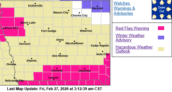
PRECAUTIONARY/PREPAREDNESS ACTIONS…
A Red Flag Warning means that critical fire weather conditions are either occurring now, or will shortly. A combination of
strong winds, low relative humidity, and warm temperatures can contribute to extreme fire behavior.
Today: Sunny, with a high near 53. Calm wind becoming west 5 to 10 mph this morning.
Tonight: Mostly clear, with a low around 30. Southwest wind around 5 mph.
Tomorrow: Sunny, with a high near 62. SW winds 5-15 mph becoming W/NW in the afternoon w/gusts to near 20 mph.
Tom. Night: Partly cloudy, with a low around 25. W/NW winds 5-15 mph becoming W/NE after midnight w/gusts to near 20 mph.
Saturday: Mostly sunny & breezy, with a high near 39.
Saturday Night: Mostly cloudy, with a low around 15.
Sunday: Cloudy w/a 60% chance of snow, mainly after noon. A high near 29.
Sunday Night: A 40% chance of snow before midnight. A low around 15.
Monday: Mostly cloudy, with a high near 36.
Wednesday’s High in Atlantic was 38 degrees. The Low this morning, was 19. We received a Trace of snow early yesterday afternoon at KJAN. Last year on this date (Feb. 26th), the High in Atlantic was 59, and the Low was 32. The Record High for this date was 78 in 2024, the record Low was -28 in 1963. Sunrise: 6:59; Sunset: 6:06.
Today: Partly cloudy to cloudy w/a slight chance of snow late this evening. A high near 39. Winds this afternoon becoming easterly @ 5-10 mph.
Tonight: Snow likely, mainly before 10pm (less than 1/2″ is expected). A low around 23.
Tomorrow: Partly sunny-to sunny. A high near 50. Winds becoming W/SW @ 6-10 mph in the morning.
Tom. Night: Mostly clear, with a low around 29.
Friday: Sunny, with a high near 62.
Friday Night: Mostly clear, with a low around 26.
Saturday: Mostly sunny & breezy, with a high near 39.
Tuesday’s High in Atlantic was 42 degrees. The Low was 26. Last year on this date (Feb. 25th), the High in Atlantic was 64, and the Low was 26. The Record High for this date was 70 in 1995, the record Low was -14 in 2010. Sunrise: 7:01; Sunset: 6:05.


