
Today: Mostly sunny. High near 86. 7-10 mph winds
Tonight: Mostly clear. Low around 63. 6 mph winds.
Tomorrow: Patchy fog before 7 AM. Mostly sunny, with a high near 85. 6 mph winds.
Tomorrow night: Mostly clear, with a low around 63. 6 mph winds
Thursday: Sunny, with a high near 84. 5 mph winds.
Thursday night: Mostly clear, with a low around 62.
Monday’s High in Atlantic was 88. The Low was 67. Last year on this date, the High in Atlantic was 84 and the Low was 52. The All-time Record High in Atlantic on Aug. 19th, was 100 in 1947. The Record Low was 41 in 1981. Sunrise: 6:32-a.m.; Sunset: 8:14-p.m.
Today: A slight chance of showers & thunderstorms before 1pm; Mostly sunny. High near 89. Heat index values as high as 100. South southwest wind 7 to 10 mph.
Tonight: A slight chance of showers & thunderstorms before 11pm. Low around 69.
Tomorrow: Mostly sunny. High near 86. 30% chance of precip.
Tomorrow night: Mostly clear. Low around 60. 6 mph winds.
Wednesday: Mostly sunny, with a high near 74.
Thursday: Sunny, with a high near 81.
Sunday’s High in Atlantic was 93. The Low was 71. Last year on this date, the High in Atlantic was 82 and the Low was 57. The All-time Record High in Atlantic on Aug. 18th, was 111 in 1936. The Record Low was 40 in 2012. Sunrise: 6:31-a.m.; Sunset: 8:15-p.m.
Today: Sunny, with a high near 92. South wind 5 to 15 mph, with gusts to near 20 mph.
Tonight: Partly cloudy w/a slight chance of showers & thunderstorms after midnight. A low around 72.
Tomorrow: A slight chance of showers & thunderstorms before 1pm; Mostly sunny. High near 91. Heat index values as high as 102. South southwest wind 5 to 10 mph.
Tom. Night: A slight chance of showers & thunderstorms after midnight. Low around 69.
Tuesday: A slight chance of showers & thunderstorms. A high near 86.
Wednesday: Mostly sunny, with a high near 81.
Thursday: Sunny, with a high near 81.
Saturday’s High in Atlantic was 95. The Low was 73. Last year on this date, the High in Atlantic was 82 and the Low was 57. The All-time Record High in Atlantic on Aug. 17th, was 108 in 1936. The Record Low was 38 in 1897. Sunrise: 6:30-a.m.; Sunset: 8:17-p.m.
Today: Mostly sunny, with a high near 94. Winds South @ 20-25 mph. **HEAT ADVISORY in effect from Noon until 8-p.m. for heat index values of up to 105 degrees**
Tonight: Partly cloudy, with a low around 73. South wind 5 to 10 mph.
Tomorrow: Mostly sunny, with a high near 93. Winds S @ 10-20 mph. Heat index values as high as 101.
Tom. Night: Partly cloudy w/a 20% chance of showers & thunderstorms overnight. A low around 73.
Monday: A slight percent chance of showers & thunderstorms, otherwise mostly sunny, with a high near 92.
Mon. Night: A 30% chance of showers & thunderstorms, mainly after midnight. Low around 69.
Tuesday: A slight chance of showers & thunderstorms, otherwise mostly sunny, with a high near 85.
Friday’s High in Atlantic was 93. The Low was 73. Last year on this date, the High in Atlantic was 87 and the Low was 62. The All-time Record High in Atlantic on Aug. 16th, was 105 in 1936. The Record Low was 48 in 1966. Sunrise: 6:29-a.m.; Sunset: 8:18-p.m.
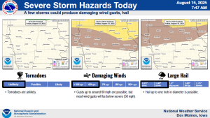
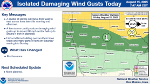
The Des Moines National Weather Service says severe weather is possible across northern Iowa, today (Friday). A line of strong to severe storms is expected to produce mainly damaging winds from 11-a.m. until 8-p.m. 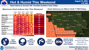
Today:**HEAT ADVISORY in effect from 1-until 7-p.m. for heat index values of up to 105-degrees** Mostly sunny w/a 30% chance of showers & thunderstorms. A high near 90. Heat index values as high as 101-105 degrees. Winds South @ 10-20 mph.
Tonight: Partly cloudy, with a low around 73. South wind around 10 mph.
Tomorrow: Sunny, with a high near 94. Heat index values as high as 102. South wind 10-20 mph.
Tom Night: Mostly clear, with a low around 73. South wind 5 to 10 mph.
Sunday: Mostly sunny, with a high near 93.
Sunday Night: Partly cloudy w/a slight chance of showers & thunderstorms after midnight. A low around 71.
Monday: Mostly sunny w/a 20% chance of showers & thunderstorms. A high near 90.
Thursday’s High in Atlantic was 84. The Low was 67. Last year on this date, the High in Atlantic was 86 and the Low was 62. The All-time Record High in Atlantic on Aug. 15th, was 103 in 1937. The Record Low was 40 in 1929. Sunrise: 6:28-a.m.; Sunset: 8:20-p.m.
(Updated 7-a.m.)
Today: A slight chance of showers & thunderstorms this morning, otherwise mostly sunny, with a high near 84. South wind 10-20 mph.
Tonight: Mostly clear, with a low around 69. S/SE winds 10-20 mph.
Friday: Mostly sunny, with a high near 91. South winds 10-20.
Friday Night: Partly cloudy, with a low around 73. South wind around 10 mph.
Saturday: Sunny, with a high near 93. South wind 10-20 mph.
Sunday: Mostly sunny, with a high near 91.
Sunday Night: A slight chance of showers & thunderstorms after midnight, otherwise partly cloudy, with a low around 72.
Monday: Mostly sunny, with a high near 89.
Wednesday’s High in Atlantic was 84. The Low was 58. Last year on this date, the High in Atlantic was 83 and the Low was 68. The All-time Record High in Atlantic on Aug. 14th, was 107 in 1936. The Record Low was 45 in 1929. Sunrise: 6:27-a.m.; Sunset: 8:21-p.m.
Today: Patchy fog before 8am. Otherwise, sunny, with a high near 82. Calm wind becoming southeast around 5 mph.
Tonight: Mostly clear, with a low around 63. East southeast wind 5 mph.
Tomorrow: Sunny, with a high near 84. South wind 5 to 15 mph, with gusts as near 25 mph.
Tom. Night: Mostly clear, with a low around 67. South southeast wind around 10-20 mph.
Friday: Mostly sunny, with a high near 89.
Friday Night: Mostly clear, with a low around 72.
Saturday: Mostly sunny, with a high near 91.
Tuesday’s High in Atlantic was 85. Our Low this morning was 58. Last year on this date, the High in Atlantic was 81 and the Low was 65. The All-time Record High in Atlantic on Aug. 13th, was 101 in 1913. The Record Low was 39 in 1964. Sunrise: 6:26-a.m.; Sunset: 8:23-p.m.
(Radio Iowa) – The latest U-S-D-A crop report shows 57 percent of the corn crop is rated good and 29 percent is rated excellent. Sixty percent of the soybeans are rated in good condition and 21 percent are rated excellent. During an interview at the Iowa State Fair, Iowa Ag Secretary Mike Naig says most of the state’s crops survived the recent derecho and other storms. “This time of year of course it can be very damaging, to a corn crop in particular when winds come like that. By and large, aside from those relatively isolated severe weather incidents, we’ve had a pretty good year by comparison. Many, many more tornadoes last year,” he says.
Naig says they are still trying to determine the extent of the crop damage. “We don’t have a total amount just yet, but there will be damage, there is crop damage in some parts of the state,” Naig says. He says the storms are the biggest wild card in farming. “Weather is one of those things that is so impactful — in fact the most impactful on your operation, ” Naig says, “and it’s one of those things they can’t control. In fact, they’ve got no control over it.”
Naig says after five years of drought it is has been good to see timely rains this year for the growing season.
(Radio Iowa) – Iowans are still enduring the heat of summer, but forecasters are already looking ahead to the winter chill. The 2026 edition of the Farmers’ Almanac is now available and editor Sandi Duncan predicts Iowans will need to make sure their furnaces are in good working condition or they’re stocked up on firewood. “The winter’s going to be on a ‘chill, snow, repeat’ pattern, meaning, it’s going to chill down, snow and then repeat again,” Duncan says. “You guys are very lucky, or unlucky, depending on how you look at it — but you guys are tough — your specific area, we’re seeing very cold conditions with a lot of snow, and in fact, the snowy and cold conditions may start a little bit early this year.”
Winter officially arrives December 21st but the almanac is predicting the first significant snowfall will hit Iowa in early December. The winter will be bone-chilling and snow-filled, what Duncan calls a classic winter wonderland, starting the second week of January. “We’re saying from the 8th to the 11th, we’re talking about very cold conditions as well as the 12th through the 15th,” Duncan says. “In February, we’re also calling for very frigid conditions from the 8th through the 11th, and we’re calling for a pretty decent snowstorm from the 16th through the 19th of February, as well as from the 20th through the 23rd.” Spring will be slow to arrive next year, so slow, she’s predicting it’ll be “sloth-like.”
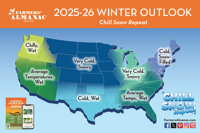
Farmers’ Almanac 2025 – 2026 winter forecast calls for a season of dramatic swings and widespread wintry weather.
“Your area’s going to have a chilled spring season with average rainfall,” Duncan says. “Looking at the month by month forecast, March looks cold and snowy. We’re having frigid conditions and also bitter cold all the way through the month of March. If you don’t like winter, you might want to make some plans for early March.” The Lewiston, Maine-based almanac boasts a forecast accuracy rate of 80% to 85%, which she says is based on a formula that was first created in 1818. “Our founding editor had come up with a way to look at celestial objects, the moon, sunspot activity, and correlate it with weather conditions here on earth,” Duncan says. “We still use some of that formula. We have made adjustments and we look at things like sunspot activity, tidal acts on the moon, the position of the planets, as well as try to factor in some atmospheric conditions.”
Besides long-term weather predictions, the Farmers’ Almanac also contains a wealth of information on gardening, cooking, home remedies, folklore, managing your household, living in harmony with nature, and more.


