
Today: Mostly cloudy to start-off, then gradually becoming sunny. High near 89. Winds S @ 10-20 mph.
Tonight: Partly cloudy, with a low around 64.
Tomorrow: A slight chance of afternoon showers & thunderstorms, otherwise Sunny. High near 89. S @ 5-10 mph.
Tom. Night: A 40% chance of showers & thunderstorms, mainly after midnight. A low around 62.
Wednesday: A 60% chance of showers & thunderstorms; Partly sunny. A high near 83.
Wed. Night: Showers likely and possibly a thunderstorm. A low around 61.
Thursday: A 60% chance of showers and possibly a thunderstorm. Mostly cloudy, with a high near 76.
Sunday’s High in Atlantic was 89. Our Low this morning was 64. Last year on this date (Sept. 15), the High in Atlantic was 89 & the Low was 58. The Record High for Sept. 15th was 99 in 1939 & the Record Low was 31 in 1961. Sunrise: 7:00; Sunset: 7:30.
Today: Mostly cloudy, with a high near 88. South wind 5 to 15 mph, with gusts near to 20 mph.
Tonight: A slight chance of showers & thunderstorms after midnight. A severe storm is possible, with the main threat being from gusty winds. A low around 65.
Monday: A slight chance of showers, with afternoon thunderstorms possible, otherwise mostly sunny, with a high near 89. Winds South at 10-20 mph.
Monday Night: Partly cloudy, with a low around 64.
Tuesday: Mostly sunny. A slight chance of afternoon showers & thunderstorms. High near 88. S @ 5-10.
Tuesday Night: A 40%chance of showers & thunderstorms, mainly after midnight. A low around 61.
Wednesday: A 60% chance of showers and thunderstorms. A high near 79.
Saturday’s High in Atlantic was 94. Our Low was 65. Last year on this date (Sept. 14), the High in Atlantic was 83 & the Low was 57. The Record High for Sept. 14th was 99 in 1939 & the Record Low was 29 in 1892. Sunrise: 6:58; Sunset: 7:31.
Today: Sunny, with a high near 93. S/SW winds 10-20 mph.
Tonight: Partly cloudy, with a low around 68. South wind 5 to 7 mph.
Tomorrow: Partly sunny, with a high near 88. Winds South @ 10-20 mph.
Tom. Night: A 20% chance of showers and thunderstorms after midnight. Low around 65. S/SE winds 5-7 mph.
Monday: Mostly sunny, with a high near 87. South winds 6-10 mph.
Monday Night: Mostly clear, with a low around 64.
Tuesday: A 20% chance of afternoon showers and thunderstorms, otherwise mostly sunny, with a high near 89.
Friday’s High in Atlantic was 89. Our Low was 68. Last year on this date (Sept. 13), the High in Atlantic was 84 & the Low was 55. The Record High for Sept. 13th was 98 in 1898 & 1939 & the Record Low was 25 in 1902. Sunrise: 6:57; Sunset: 7:33.
(Radio Iowa) – The calendar says it’s mid-September but it’s feeling a lot more like mid-July. National Weather Service meteorologist Andrew Ansorge says we have several days of unseasonable heat ahead. “We’re looking at a warm-to-hot stretch of weather here from today through early next week at least,” Ansorge says, “probably going into the middle of next week, with highs any of these days well into the 80s, if not the 90s.” The forecast for many communities across southern and central Iowa calls for highs in the mid-90s, but he says it’s unlikely we’ll see many records set, if any.
“The only record that currently could be challenged or broken would be at Des Moines on Saturday and that’s where we have a record of 96 from 1939. Our current forecast is 95,” Ansorge says. “There aren’t a lot of record highs that we’re challenging with this round of heat, but it’s late in the season to have these kind of temperatures, so people will still want to take the typical precautions if they have outdoor events or plans.”
That includes wearing a hat, sunscreen, and light weight and light colored clothing, avoiding strenuous activities outside, staying in the shade as much as possible, and drinking plenty of non-alcoholic beverages. Your yard and garden may need a drink, too. “This heat’s going to last early to mid next week and then we do have a front that’s going to slowly move in,” Ansorge says, “and that’s when we could see some chances for showers and storms return to the forecast, as well as some seasonable temperatures by late next week.”
The average high temperature for today in Des Moines is 78 degrees, while the forecast calls for it to reach 93.
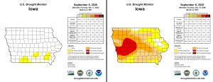
DES MOINES, Iowa — After very soggy weather across the state earlier this summer, including the wettest July on record in Des Moines, abnormally dry conditions have returned to Iowa for September. With the lack of rain, especially over central and southern Iowa, the national drought monitor now shows portions of southern Iowa in the abnormally dry category. With limited rainfall expected over the next week, those dry regions are likely to expand.
Today: Mostly sunny, warm & breezy. A high near 90. Winds S/Se @ 10-20 mph w/gusts to near 25.
Tonight: Partly cloudy, with a low around 67. South wind 5 to 10 mph.
Tomorrow: Mostly sunny, with a high near 92. S/SW winds 10-20 mph.
Tom. Night: Mostly cloudy, with a low around 68. South wind around 5-10 mph.
Sunday: Partly sunny, with a high near 88.
Sunday Night: A chance of showers & thunderstorms after midnight. Low around 65.
Monday: Mostly sunny, with a high near 88.
Tuesday: Mostly sunny, with a high near 87.
Thursday’s High in Atlantic (at KJAN) was 87. The Low was 55. Last year on this date (Aug. 12th), the High in Atlantic was 86 & the Low was 52. The All-time Record High on Aug. 12th in Atlantic was 97 in 1939 & 2000, & the Record Low was 28 in 1902. Sunrise: 6:57; Sunset: 7:35.
Today: Sunny, with a high near 85. Light east wind becoming southeast at 5 to 10 mph in the morning.
Tonight: Partly cloudy, with a low around 67. East southeast wind 5 to 10 mph.
Friday: Mostly sunny, with a high near 90. S/SE winds 10-tp near 25 mph.
Friday Night: Partly cloudy, with a low around 67. South wind 5-10 mph.
Saturday: Mostly sunny, with a high near 92.
Saturday Night: Mostly cloudy, with a low around 69.
Sunday: A slight chance of afternoon showers & thunderstorms, otherwise partly sunny, with a high near 88.
Sunday Night: A 40% chance of showers and thunderstorms. Low around 63.
Monday: Mostly sunny, with a high near 86.
Wednesday’s High in Atlantic (at KJAN) was 84. The Low this morning was 55. Last year on this date (Aug. 11th), the High in Atlantic was 86 & the Low was 52. The All-time Record High on Aug. 11th in Atlantic was 96 in 1895 & 1936, & the Record Low was 31 in 1955. Sunrise: 6:56; Sunset: 7:37.
Today: Some patchy fog this morning, otherwise, mostly sunny. A high near 82. Winds E @ around 5 mph in the afternoon.
Tonight: Mostly clear, with a low around 60. East northeast wind around 5 mph.
Tomorrow: Mostly sunny, with a high near 86. Southeast wind 5 to 10 mph.
Tom. Night: Partly cloudy, with a low around 65. Southeast wind 5 to 10 mph.
Friday: Mostly sunny, with a high near 89.
Friday Night: Partly cloudy, with a low around 68.
Saturday: Mostly sunny, with a high near 91.
Saturday Night: Partly cloudy, with a low around 68.
Sunday: Partly sunny, with a high near 87.
Tuesday’s High in Atlantic (at KJAN) was 78. The Low this morning was 57. We received .05″ rain. Last year on this date (Aug. 10th), the High in Atlantic was 85 & the Low was 54. The All-time Record High on Aug. 10th in Atlantic was 98 in 1938, & the Record Low was 36 in 1959.
From official NWS reporting sites:
Atlantic (KJAN), .39″
Atlantic (7.1 miles N/NE), .35″
Cromwell, Trace of rain
Council Bluffs, .48″
Earling, .24″
Elk Horn, .36″
Hastings, .07″
Imogene, .04″
New Market, Trace of rain
Pacific Junction, .01″
Thurman, .06″
Public reports to area media:
Between Elk Horn & Kimballton, .75″
Griswold, 1.2″
Hancock & Avoca, .60″
Neola (just north of town), .30″
Today: A 30% chance of showers & thunderstorms, mainly before 9am. Mostly cloudy. A high near 75. Winds S @ 10-20 mph.
Tonight: Partly cloudy, with a low around 59. South wind around 5 mph.
Wednesday: Mostly sunny, with a high near 83. Calm wind becoming SE @ around 5 mph in the afternoon.
Wednesday Night: Mostly clear, with a low around 59.
Thursday: Mostly sunny, with a high near 86.
Friday: Mostly sunny, with a high near 90.
Saturday: Mostly sunny, with a high near 89.
Monday’s High in Atlantic was 79. The Low was 56. Last year on this date, the High in Atlantic was 84 & the Low was 49. The All-time Record High on Sept. 9th in Atlantic, was 100 in 1893, & the Record Low was 36 in 1959. Sunrise: 6:53; Sunset: 7:40.


