
(Radio Iowa) – Natural disasters in Iowa that cause millions and even billions of dollars damage are becoming more frequent, which some experts blame on our changing climate. The 15th annual Iowa Climate Statement was released today (Monday), endorsed by 177 Iowa science faculty at 24 colleges and universities statewide. Dave Courard-Hauri, a professor of environmental science and sustainability at Drake University, says the cost of disasters like droughts and floods don’t impact just those who file insurance claims.
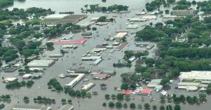
2024 flooding in Spencer. (Iowa DOT photo)
“With climate change increasing risks from extreme events, that cost will increase for all of us,” Courard-Hauri says. “Given that homeowners insurance is required to obtain a mortgage, as insurance costs become prohibitive, or as companies choose not to insure in areas of high risk, the entire housing market can experience ripple effects.” While farmers are especially vulnerable to natural disasters and their associated costs, the report says the American dream of homeownership may become unattainable for some Iowa families as climate change accelerates the rise in insurance premiums.
Bill Gutowski, professor emeritus of meteorology at Iowa State University, says temperatures are rising globally due to an increase in greenhouse gases which is caused by the burning of fossil fuels. “These higher temperatures allow more moisture in the atmosphere, which yields a tendency for more precipitation when storms do occur, and that leads to more flooding,” Gutowski says. “When that water condenses, it adds energy in the form of heat to those storms, which can make them stronger, especially the severe weather storms we experience in late spring to early summer.”
When adjusted for inflation, the report says billion-dollar disasters in the region encompassing Iowa have more than doubled over the past 40 years. Peter Thorne, a professor of occupational and environmental health at the University of Iowa, says these Midwest events are part of an emerging global trend of shattered long-term climate records, with growing losses of life and property, resulting in higher insurance costs.
“Rising insurance premiums in Iowa are driven by increased costs of labor, building materials and reinsurance,” Thorne says, “and the reinsurance industry is that which ensures the insurers. They tie their rates to national and international risks that are being driven by climate change. So these costs all are amplified by climate change and are escalating.” Property owners in Iowa can make moves to try and reduce their own carbon footprints and to reduce their insurance costs.
Emma Stapleton, a research professor of internal medicine at the University of Iowa, says for example, trees can be planted as natural wind buffers, and there are all sorts of “smart” building materials for construction. “There are some benefits to consumers for energy efficient upgrades, like better insulation, things like reducing the risk of fire with building materials,” Stapleton says. “Some policies do give you green update coverages where you can rebuild or replace the damaged parts of your house with environmentally friendly materials.”
The report says some insurance companies have pulled out of Iowa and elsewhere after recent disasters, like the 2020 derecho. Gutowski says every one of the Earth’s ten hottest years on record has occurred in the last decade, with 2024 breaking all previous records. He says those temperature changes lead to the types of extreme events and damages that we have seen more of in recent years.
(Radio Iowa)- Iowans who are bundled up in their winter coats, hats and gloves today (Monday) may be back in shorts and t-shirts to wrap up their yard work by the weekend. Meteorologist Brooke Hagenhoff, at the National Weather Service, says we’re in for a big warmup soon, but it follows a weekend during which most Iowans saw at least some snowfall, with accumulation in several areas. “We had places that saw between two and five inches of snow over the weekend,” Hagenhoff says. “Really far northwest Iowa saw the most. Between Estherville to Okoboji saw between that four to five inch amounts, and then we had places that saw two to four surrounding that.” After a weekend of below-freezing temperatures, much of the state will only have highs in the 30s today, but Hagenhoff says that’ll quickly change.
“We’ve got one more chilly day here today, and then we definitely see a big swing starting tomorrow, mid 50s across the area,” Hagenhoff says. “By the time we get to Friday, we’re looking at mid to upper 60s, especially across central to southern Iowa.” While it likely won’t be warm enough this weekend to need the air conditioner, she says it’ll be a good bet you can turn off the furnace, at least temporarily. “Normal highs for this time of year are right around 50 to 52°, in that range for this week, so we’re going to go from about 15° below normal to 15 to 20° above normal for this time of year,” Hagenhoff says, “so a big swing here coming up after what was a really cool weekend and our first shot of winter.”
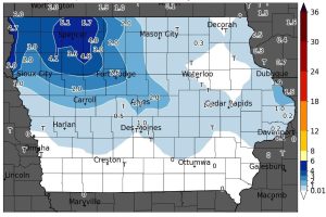
Weekend snowfall graphic from the Iowa Environmental Mesonet via the National Weather Service)
We’re still more than a month from the start of winter, which officially arrives December 21st.
Today: Sunny, with a high near 36. Winds N/NW @ 5-10 this morning becoming SW this afternoon. Wind chill values as low as 5.
Tonight: Increasing clouds & breezy, with a low around 24. Winds S/SW @ 5-15 mph w/gusts to near 25.
Veterans Day: Cloudy-to-partly cloudy. A high near 58. S/SW @ 5-15 in the morning becoming W/NW in the afternoon, and gusting to near 25 mph.
Tuesday Night: Mostly clear, with a low around 33.
Wednesday: Sunny, with a high near 57.
Wednesday Night: Partly cloudy, with a low around 36.
Thursday: Mostly sunny, with a high near 62.
Sunday’s High in Atlantic was 30. Our Low this morning (& 24-hour Low), was 16. Last year on this date (Nov. 10th), the High in Atlantic was 57 & the Low was 32. The Record High for Nov. 10th in Atlantic, was 76 in 1927. The Record Low was 3 in 1986. Sunrise: 7:02; Sunset: 5:05.
Atlantic (at KJAN), .33″
Atlantic (7.1 miles N/NE), .36″
Massena, .13″
New Market, T (trace)
Today: Mostly sunny, with a high near 31. Winds N/NW @ 15-30 mph. Wind chill values as low as 5.
Tonight: Mostly clear, with a low around 17. N/NW winds 10-20 mph.
Tomorrow: Sunny, with a high near 36. N/NW winds 5-10 in the morning becoming S/SW in the afternoon.
Tom. Night: Mostly cloudy, with a low around 23. Winds S @ 5-15 w/gusts to near 25 mph.
Veterans Day (Tuesday): Mostly sunny, with a high near 58.
Tuesday Night: Mostly clear, with a low around 34.
Wednesday: Sunny, with a high near 57.
Saturday’s High in Atlantic was 40. Our Low this morning (as of 5-a.m.) was 21. (We will post 24-hour rainfall at 7-a.m.). Last year on this date (Nov. 9th), the High in Atlantic was 53 & the Low was 45. The Record High for Nov. 9th in Atlantic, was 76 in 2022. The Record Low was 8 in 1973. Sunrise: 7:01; Sunset: 5:06.
Atlantic (@KJAN), .10″
Atlantic (7.1 miles N/NE), .05″
Council Bluffs, .06″
Earling, .10″
Elk Horn, .06″
Imogene, .03″
Logan, .11″
Manning, .07″
Missouri Valley, .11″
Mondamin, .11″
New Market, T (trace of rain)
Persia, .13″
Thurman, .02″
Today: Rain and snow. Little or no snow accumulation expected. High near 37. East wind 5 to 10 mph becoming north northwest in the afternoon.
Tonight: A chance of rain and/or snow flurries until about midnight. Gradually becoming partly cloudy, with a low around 19. Wind chill values as low as 10. Little or no snow accumulation expected.
Sunday: Sunny & breezy, with a high near 32. Winds N/NW @ 15-25 mph. Wind chill values as low as 5.
Sunday Night: Mostly clear, with a low around 16. N/NW winds 5-10 mph, with gusts to near 20 mph.
Monday: Sunny, with a high near 36.
Veterans Day (Tuesday): Mostly sunny, with a high near 58.
Wednesday: Sunny, with a high near 56.
Friday’s High in Atlantic was 65. The Low was 32. We received .10″ of rain overnight through 7-a.m. today. Last year on this date (Nov. 8th), the High in Atlantic was 62 & the Low was 35. The Record High for Nov. 8th in Atlantic, was 80 in 1999 & 2006. The Record Low was -12 in 1991. Sunrise: 7:00; Sunset: 5:07.
The Des Moines National Weather Service has produced a weather briefing concerning the following hazardous winter weather.
* WHAT – First snowfall of the season.
* WHERE – Most likely in northwestern to north central Iowa, but possible farther south and east as well.
* WHEN – On Saturday, with a few additional snow showers Saturday night.
The briefing is available at https://www.weather.gov/media/dmx/DssPacket.pdf. Additional winter specific information can be found at https://www.weather.gov/dmx/dsswinter
The next email briefing is scheduled to be sent by around 7 AM on Saturday, November 8. 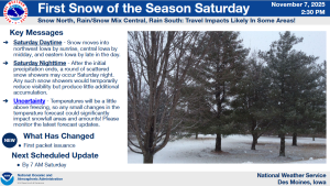
Today: Sunny & breezy, with a high near 62. W/NW winds 10-20 mph w/gusts to around 25 mph.
Tonight: Cloudy w/a 60% chance of rain and/or snow, mainly after midnight. Low around 36. Little or no snow accumulation expected.
Tomorrow: Rain and snow likely, becoming all rain after 9am. A high near 45. E winds @ 5-10 in the morning becoming N/NW in the afternoon. Little or no snow accumulation expected.
Tom. Night: Blustery, w/a chance of rain and snow before midnight. A low around 20. Winds N @ 10-25 mph. Little or no snow accumulation expected.
Sunday: Sunny & breezy, with a high near 34.
Monday: Sunny, with a high near 39.
Veterans Day (Tuesday): Mostly sunny, with a high near 58.
Thursday’s High in Atlantic was 60. The Low was 37. Last year on this date (Nov. 7th), the High in Atlantic was 57 & the Low was 32. The Record High for Nov. 7th in Atlantic, was 77 in 1915. The Record Low was -14 in 1991. Sunrise: 6:59; Sunset: 5:08.
(Radio Iowa) – Some Iowans could see their first snowflakes of the season this weekend. Meteorologist Dylan Dodson, at the National Weather Service in Johnston, says there are still a lot of uncertainties in the forecast, especially across northern Iowa. “Because the temperature differences at the surface are going to matter a lot,” Dodson says. “One to two degrees could be the difference between rain or snow for you with this system as these typically are towards the beginning of the season.”
While today (Thursday) and Friday should feature unseasonably warm weather, the storm front will move in on Saturday, though the only sure thing is — it’ll be dropping some form of precipitation. “It’s tough to say how much we’re going to get,” Dodson says. “You could see some areas that just get all rain. There could be some areas that look at one to two, maybe even three inches of snowfall. It definitely is going to vary depending on where you’re at and what the temperature is in that area.”
While the forecast calls for parts of the state to experience low temperatures in the teens by Sunday night, highs could be back to near 60 by the middle of next week.


