
Today: A 40 percent chance of showers and thunderstorms, mainly after noon. Partly sunny, with a high near 84. West wind 5 to 10 mph becoming east in the afternoon. New rainfall amounts of less than a tenth of an inch, except higher amounts possible in thunderstorms.
Tonight: A 20 percent chance of showers and thunderstorms. Mostly cloudy, with a low around 59. East wind around 9 mph.
Thursday: Mostly sunny, with a high near 81. East southeast wind 8 to 10 mph.
Friday: A 20 percent chance of showers and thunderstorms after 1pm. Mostly sunny, with a high near 82.
Saturday: Showers and thunderstorms likely. Partly sunny, with a high near 81. Chance of precipitation is 70%.
Tuesday’s high in Atantic was 90 and the low was 62. This day last year the high was 82 and the low was 60. The all-time record high was 98 set in 1934 & 2011, and the low was 36 in 1894. Sunrise today was at 5:46 a.m., sunset at 8:51 p.m.
(Radio Iowa) – After a few weeks of modest improvements, drought conditions are again worsening in many parts of Iowa as the hottest, driest season of summer is about to begin. Despite a few recent rain showers that soaked some areas of Iowa, state climatologist Justin Glisan says many other areas remain bone-dry, and June is already starting out quite warm.
“We’re about eight degrees above average for the first five days,” Glisan says. “We have had some spotty rainfall, pop-up thunderstorms, on several days last week. If we look at the outlooks in the short term, so getting out into the middle of June, we are seeing a near-normal to slightly elevated signal for somewhat warmer temperatures through the middle of the month.”
Computer models also indicate we may be trending toward near-normal precipitation to perhaps wetter-than-average conditions. Looking back at spring, which is traditionally March, April and May, it was the opposite. “We started spring on the wetter side and we started May on the wetter side as well,” Glisan says, “but overall we had about 6.2 inches across the state over those three months, when we expect about 11 inches, so almost four inches below average.”
Glisan says it’s shaping up to be the 20th driest spring on record for Iowa, and rainfall during May was scarce. “Overall, you look at the statewide average, May being the second-wettest month climatologically, we’re right around 2.7 inches,” Glisan says, “and that’s a little over two inches below average. If we look at rankings going back 151 years, this is nearing the 25th the driest May on record.” The just-concluded month was also warmer than normal.
“We were above average by about two degrees, so warmer than average for May,” he says, “but we also had lower dew point temperatures, so we were able to cool off at night, so it didn’t feel like a particularly warm month until the end of the month.” A few counties in far eastern and northeastern Iowa are considered “normal” on the latest U-S Drought Monitor map, while roughly 53 counties are considered abnormally dry, and around 40 counties are in moderate to exceptional drought.
Today: Sunny, with a high near 89. Calm wind becoming west southwest around 6 mph in the morning.
Tonight: A 20 percent chance of showers and thunderstorms after 4am. Partly cloudy, with a low around 66. West southwest wind around 6 mph becoming east southeast in the evening.
Wednesday: Showers and thunderstorms likely, mainly after 1pm. Mostly sunny, with a high near 86. East wind 6 to 8 mph. Chance of precipitation is 60%. New rainfall amounts between a tenth and quarter of an inch, except higher amounts possible in thunderstorms.
Thursday: A 20 percent chance of showers after 1pm. Mostly sunny, with a high near 82.
Friday: A 30 percent chance of showers after 1pm. Mostly sunny, with a high near 85.
Monday’s high was 90 and the low was 60. This day last year the high was 78 and the low was 57. The all-time record high was 103 set in 1933 and the low was 32 in 1894. Sunrise today was at 5:46 a.m. and sunset will be at 8:50 p.m.
Today: Increasing clouds, with a high near 87. East wind around 6 mph.
Tonight: Partly cloudy, with a low around 62. East southeast wind around 6 mph becoming light and variable after midnight.
Tuesday: A 30 percent chance of showers and thunderstorms, mainly after 4pm. Mostly sunny, with a high near 87. Light and variable wind becoming west southwest around 6 mph in the morning.
Tuesday Night: A chance of showers and thunderstorms before 7pm, then a slight chance of showers and thunderstorms after 1am. Mostly cloudy, with a low around 64. North wind around 6 mph becoming south after midnight. Chance of precipitation is 30%.
Wednesday: Showers and thunderstorms likely, mainly after 1pm. Partly sunny, with a high near 85. Chance of precipitation is 60%. New rainfall amounts between a tenth and quarter of an inch, except higher amounts possible in thunderstorms.
Thursday: Mostly sunny, with a high near 81.
Sunday’s high was 91 and the low was 62. This day last year the high was 83 and the low was 61. The all-time record high was 104 set in 1933 and the low was 40 in 1897 & 1935. Sunrise today was at 5:47 a.m. and sunset will be at 8:50 p.m.
Today: A 30 percent chance of showers and thunderstorms, mainly after 3pm. Mostly sunny, with a high near 87. East northeast wind 5 to 10 mph. New rainfall amounts of less than a tenth of an inch, except higher amounts possible in thunderstorms.
Tonight: A 20 percent chance of showers and thunderstorms before 9pm. Partly cloudy, with a low around 60. East northeast wind 6 to 8 mph. ![]()
Monday: Mostly sunny, with a high near 87. East wind around 6 mph.
Tuesday: A 30 percent chance of showers and thunderstorms after 1pm. Mostly sunny, with a high near 87. Calm wind becoming west around 6 mph in the morning.
Wednesday: A 30 percent chance of showers and thunderstorms after 1pm. Partly sunny, with a high near 84.
Saturday’s high was 89 and the low was 60. This day last year the high was 75 and the low was 58. The all-time record high was 96 set in 1914 and the low was 31 in 1945. Sunrise today was at 5:47 a.m. and sunset will be at 8:49 p.m.
Skyscan Forecast Saturday, June 03, 2023 Chris Parks
Today: Slight chance of showers and thunderstorms after 1:00 p.m. Otherwise mostly sunny with a high near 89. ESE @ 5-10.
Tonight: Mostly clear. ENE @ 5-10. Low around 63.
Sunday: A moderate chance of showers and thunderstorms in the afternoon. Otherwise mostly sunny. E @ 5-10. High 87.
Monday: Slight chance of showers and thunderstorms after 1:00 p.m. Otherwise sunny with a high near 87. ENE @ 10.
Tuesday: Slight chance of showers and thunderstorms in the afternoon. Mostly sunny. High 87.
Wednesday: Mostly sunny. High 81.
Yesterday’s high was 86 and the low was 61. We picked up 1.16″ of rain in the past 24-hr period at the KJAN studios. This day last year the high was 84 and the low was 57. The all-time record high was 94 set in 2020 and the low was 32 in 1969. Sunrise today is 5:47 a.m. and sunset will be at 8:48 p.m.
(Ames, Iowa) – The latest Iowa Drought Monitor (Released Thursday, June 1) indicated a continued trend toward dryness across the State. Only the north-central & northeast counties are free of drought conditions.The report is released every Thursday, and does not take into account rain received since the report was issued. Atlantic finally received some decent rain Thursday, at slightly more than nine-tenths of an inch. The last time we received over nine-tenths of an inch, was May 5th (.94″). The National Weather Service says a high-pressure system parked over the Great Lakes continues to block any organized weather system from entering the state.
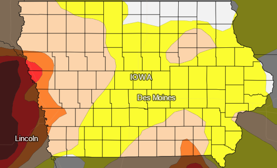
White-No drought; Yellow-Abnormally dry; Tan-Moderate drought; Orange-Severe drought; Red-extreme drought; dark red-Exceptional drought.
Drought areas are categorized from D-O (no drought) to D-4 (Exceptional Drought). The Drought Monitor shows drought conditions continued expanding across the region, from D-O to D-1 (Abnormally Dry) in parts of Illinois, Iowa and Missouri. D-2 soil/drought conditions expanded in Iowa and Missouri, while D-3 (Extreme Drought) conditions grew in Missouri. As of May 28th, USDA data revealed more than half of the topsoil moisture was short or very short in Iowa (50%), Missouri (62%), and Michigan (68%), and 40% or more was short or very short in Wisconsin (45%), Ohio (45%), Illinois (42%), and Indiana (40%).
The story for the Midwest was continued drying of soils, low streamflows, and mounting precipitation deficits over the last 1 to 3 months.
Today: Scattered showers and thunderstorms, mainly after 1pm. Partly sunny, with a high near 86. South southeast wind 5 to 8 mph. Chance of precipitation is 50%. New rainfall amounts between a tenth and quarter of an inch, except higher amounts possible in thunderstorms.
Tonight: A 20 percent chance of showers and thunderstorms before 1am. Partly cloudy, with a low around 63. South southeast wind around 5 mph becoming light and variable.
Saturday: A 40 percent chance of showers and thunderstorms, mainly after noon. Mostly sunny, with a high near 88. East southeast wind 5 to 10 mph. New rainfall amounts between a tenth and quarter of an inch, except higher amounts possible in thunderstorms.
Saturday Night: Mostly clear, with a low around 63. East wind 6 to 10 mph.
Sunday: A slight chance of showers, then a chance of showers and thunderstorms after 10am. Sunny, with a high near 89. Chance of precipitation is 30%.
Sunday Night: A chance of thunderstorms before 7pm. Mostly clear, with a low around 62. Chance of precipitation is 30%.
Monday: A 20 percent chance of showers and thunderstorms after 1pm. Sunny, with a high near 90.
Thursday’s High in Atlantic was 85. The Low was 66. We received .93″ rain Thursday. Last year on this date the High in Atlantic was 79 and the Low was 46. The Record High on this date was 100 in 1934. The Record Low was 36 in 1907. Sunrise is 5:48. Sunset at 8:48.
(Atlantic, Iowa/KJAN) – The month of May in Atlantic, was warmer than average, and much drier. Our average high for the month was 78, while the average low was 50. The normal average High and Low is 73 and 49. Rainfall for the month amounted to 1.72 inches. Normally, we would have received about 4.3 inches.
Here’s what we might expect weather-wise, during the month of June, in Atlantic: An average High of 83, and an average Low of 59. Precipitation typically amounts to 4.98-inches.
KJAN is the OFFICIAL National Weather Service reporting site for Atlantic data.


