
Today: Patchy fog before 8am. Otherwise, sunny, with a high near 90. Calm wind becoming south 5 to 10 mph.
Tonight: Clear, with a low around 65. Southeast wind around 10 mph.
Tuesday: Sunny, with a high near 89. Southeast wind 10 to 15 mph.
Tuesday Night: Mostly clear, with a low around 63. East southeast wind around 10 mph.
Wednesday: Sunny, with a high near 89. East southeast wind around 10 mph.
Thursday: Sunny, with a high near 88.
Yesterday’s high was 83 and the low was 59. This day last year the high was 93 and the low was 70. The all-time record high was 104 set in 1974. The record low was 42 set in 1900. Sunrise is at 5:45 a.m. and sunset is 8:56 p.m.
Today: Patchy fog before 8am. Otherwise, mostly cloudy through mid morning, then gradual clearing, with a high near 82. West northwest wind 5 to 7 mph.
Tonight: Mostly clear, with a low around 62. West wind 5 to 7 mph becoming southeast in the evening.
Tomorrow: Sunny, with a high near 91. South southeast wind 5 to 10 mph.
Tuesday: Sunny, with a high near 89. Southeast wind 9 to 14 mph, with gusts as high as 20 mph.
Wednesday: Mostly sunny, with a high near 89.
Saturday’s High in Atlantic was 87. The Low was 60. We received .43″ rain Saturday, at the KJAN Studios. Last year on this date, the High in Atlantic was 92, and the Low was 70. The Record High for June 18th in Atlantic, was 98 in 1910. The Record Low was 46, in 1974 & 2000.
Today: Widespread haze between 7am and noon. Mostly sunny, with a high near 87. East wind 6 to 10 mph.
Tonight: A 20 percent chance of showers and thunderstorms after 3am. Partly cloudy, with a low around 62. East southeast wind around 8 mph.
Saturday: Showers and thunderstorms, mainly after 1pm. High near 84. South wind 9 to 11 mph. Chance of precipitation is 80%. New rainfall amounts between a quarter and half of an inch possible.
Saturday Night: Showers and thunderstorms likely before 10pm, then showers likely and possibly a thunderstorm between 10pm and 1am, then a chance of showers and thunderstorms after 1am. Mostly cloudy, with a low around 60. South southwest wind 6 to 8 mph. Chance of precipitation is 70%. New rainfall amounts between a tenth and quarter of an inch, except higher amounts possible in thunderstorms.
Sunday: A 40 percent chance of showers and thunderstorms. Mostly sunny, with a high near 83. New rainfall amounts of less than a tenth of an inch, except higher amounts possible in thunderstorms.
Monday: Sunny, with a high near 87.
Thursday’s High in Atlantic was 89. The Low was 55. Last year on this date, the High in Atlantic was 89, and the Low was 62. The Record High on this date in Atlantic, was 103 in 1946. The Record Low was 42 in 1974. Sunrise today: 5:45; Sunset: 8:56.
Today: Mostly sunny, with a high near 89. West southwest wind around 6 mph.
Tonight: Partly cloudy, with a low around 61. South wind around 6 mph becoming east after midnight.
Friday: Mostly sunny, with a high near 89. East wind around 7 mph.
Friday Night: A 30 percent chance of showers and thunderstorms, mainly after 1am. Partly cloudy, with a low around 63. East southeast wind 7 to 9 mph.
Saturday: Showers and thunderstorms likely, mainly after 1pm. Partly sunny, with a high near 84. Chance of precipitation is 60%. New rainfall amounts between a tenth and quarter of an inch, except higher amounts possible in thunderstorms.
Saturday Night: Showers and thunderstorms likely, mainly before 4am, then showers likely and possibly a thunderstorm after 4am. Mostly cloudy, with a low around 60. Chance of precipitation is 70%.
Sunday: A 50 percent chance of showers and thunderstorms. Partly sunny, with a high near 80.
Wednesday’s High in Atlantic was 88. The Low was 53. Last year on this date, the High in Atlantic was 77 and the Low was 59. The Record High was 99 in 1918, and the Record Low was 40 in 1906 & 1969. Sunrise is at 5:45. Sunset is at 8:56.
(Radio Iowa) – There’s smoke over Iowa again from the Canadian wildfires, but National Weather Service Meteorologist, Brad Small says that smoke is high up and not causing problems. “We’ve seen a little bit over northwest and west-central Iowa in the midday here. It’s much worse to our north however from the eastern Dakotas into Minnesota it’s actually getting down to the surface there where we’ve had visibility dropped to a few miles in places,” Small says. He says a variety of factors impact how low the smoke hangs in the air.
“Smoke density wind speed thermodynamic properties of the atmosphere all come into play it’s fairly rare to get smoked down to the surface this far removed from the fires down here in Iowa,” Small says, “but it can’t happen and hopefully in this case it’s all stay to our north and northeast.” Small says the smoke issues were bigger in New York and other eastern states recently because they are closer to the source. He says things could change in Iowa.
“The biggest concerns that looks like for the next couple of days are going to be northeast of us, the smoke might get down to the surface in far northeast Iowa,” he says. Small says the rest of the state shouldn’t see any low hanging smoke.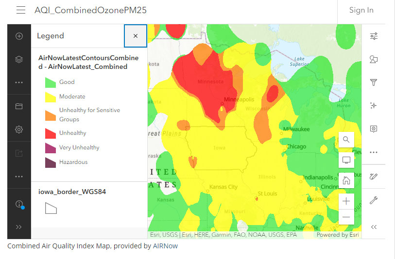 The D-N-R’s air quality measurements show air quality concerns only in a small area in the northwest and southwest corners of the state.
Today: Mostly sunny, with a high near 86. West wind around 6 mph.
Tonight: Partly cloudy, with a low around 59. Southwest wind around 6 mph.
Tomorrow: Sunny, with a high near 89. Southwest wind 3 to 8 mph.
Friday: Mostly sunny w/a 30% chance of showers and thunderstorms in the afternoon. High near 87.
Friday Night: A 50% chance of showers and thunderstorms. Low around 63.
Saturday: A 60% chance of showers and thunderstorms, otherwise partly sunny, with a high near 82.
Tuesday’s High in Atlantic was 84. The Low was 57. Last year on this date, the High in Atlantic was 96 and the Low was 66. The Record High was 97in 1987, and the Record Low was 41in 1933. Sunrise is at 5:45. Sunset is at 8:55.
Today: Sunny, with a high near 83. West wind around 11 mph.
Tonight: Partly cloudy, with a low around 55. West wind 6 to 9 mph.
Wednesday: Mostly sunny, with a high near 86. West northwest wind around 6 mph.
Thursday: Sunny, with a high near 88.
Thursday Night: A 20 percent chance of showers and thunderstorms. Partly cloudy, with a low around 62.
Friday: A 50 percent chance of showers and thunderstorms. Partly sunny, with a high near 85.
Monday’s High in Atlantic was 77. The Low was 47. Last year on this date, the High in Atlantic was 100 and the Low was 79. The Record High was 100 in 2022, and the Record Low was 37 in 1906. Sunrise is at 5:45. Sunset is at 8:54.
(Radio Iowa) – This week’s Iowa Crop and Weather report from the U-S-D-A rates 60 percent of Iowa topsoil either short or very short of moisture. State Climatologist Justin Glisan says abnormally dry conditions have expanded in the past two weeks. “In those more pervasive and dry areas, we’ve seen precipitation deficits really stack up,” Glisan says. “This is reflected in lower stream flows, but also diminishment in soil moisture.”
By last Thursday, 99 percent of the state reached some stage of drought or has been abnormally dry for 30 to 60 days according to the U-S-D-A’s Iowa Drought Monitor. Glisan says it appears surface temperatures in the eastern Pacific Ocean are rising — and that means a change in the weather pattern for thunderstorms that form over the ocean and later sweep into Iowa.
“I think there is good news on the horizon,” Glisan says. Weather models indicate the swing into the wetter pattern could arrive in Iowa by July, according to Glisan, just when corn and soybeans hit a major stage in development. “We need timely rainfalls throughout the teeth of the growing season,” Glisan says, “so seeing this potential shift into El Nino, which we are in now, and the potential for the weather patterns that set up, I am pretty confident that we are not going to see any yield loss because of early planting.”
Glisan made his comments during a recent appearance on “Iowa Press” on Iowa P-B-S. According to the U-S-D-A, the development of Iowa’s soybean crop is nine days ahead of normal and the corn crop is a week ahead of last year.
(Radio Iowa) – Some Iowa cities set record low temperatures this (Monday) morning. The National Weather Service in La Crosse received a report that the temperature fell to 35 in Elkader in northeast Iowa. There was a record low in Cedar Rapids of 40 degrees. It dipped to 41 in Mason City and Ottumwa, also records for this date. The low in Atlantic (43) fell five-degrees short of tying the record (38) set in 1903.
Alexis Jimenez is a meteorologist with the National Weather Service in central Iowa. “We saw low to mid 40s throughout much of the state,” Jimenez says. Temperatures for the rest of the day will be in the 70s. “It’ll be really a perfect day weather wise. You can’t get much better. You can’t ask for more in the middle of June, but we will see a warming trend starting tomorrow,” she says. “We’ll see temperatures climb into the 80s and then we’ll see temperatures close to 90 Thursday.”
The record low in Iowa for this date was set in 1903. The temperature fell to 30 degrees in Fayette according to federal records from the National Oceanic and Atmospheric Administration.


