
Atlantic (KJAN), .44
Massena, .50 (½ inch)
Adair-.43
Council Bluffs-.93
Harlan-.45
Lewis- .60
Lyman-1.0
Wiota-.49
Today: Partly sunny, with a high near 76. North wind around 8 mph.
Tonight: Partly cloudy, with a low around 52. North northwest wind 3 to 7 mph.
Sunday: Sunny, with a high near 80. Calm wind becoming west northwest around 6 mph in the morning.
Sunday Night: Clear, with a low around 58. West wind around 6 mph becoming south after midnight.
Monday: Sunny, with a high near 86. Southwest wind 9 to 13 mph, with gusts as high as 18 mph.
Monday Night: A 40 percent chance of showers and thunderstorms. Partly cloudy, with a low around 62. New rainfall amounts between a tenth and quarter of an inch, except higher amounts possible in thunderstorms.
Tuesday: A slight chance of showers, with thunderstorms also possible after 1pm. Sunny, with a high near 87. Chance of precipitation is 20%.
Friday’s High in Atlantic was 66. Our Low this morning, 57. We received .44″ rain Friday. Last year on this date, the High in Atlantic was 85, and the Low was 64. The Record High was 102 in 1937. The Record Low was 42 in 1908. Sunrise is at 5:53. Sunset is at 8:56.
(Radio Iowa) – Dry conditions are lessening — ever so slightly — in Iowa, according to the latest report from the U-S Drought Monitor. The new map shows roughly 87 of Iowa’s 99 counties are in some level of drought, that’s down from 89 counties last week. More than 80 counties are in either moderate or severe drought, while portions of 14 counties in western and southeastern Iowa are in extreme drought. Almost all of the remainder are considered abnormally dry, while moisture levels are only considered normal in parts of Osceola and Dickinson counties in northwest Iowa. 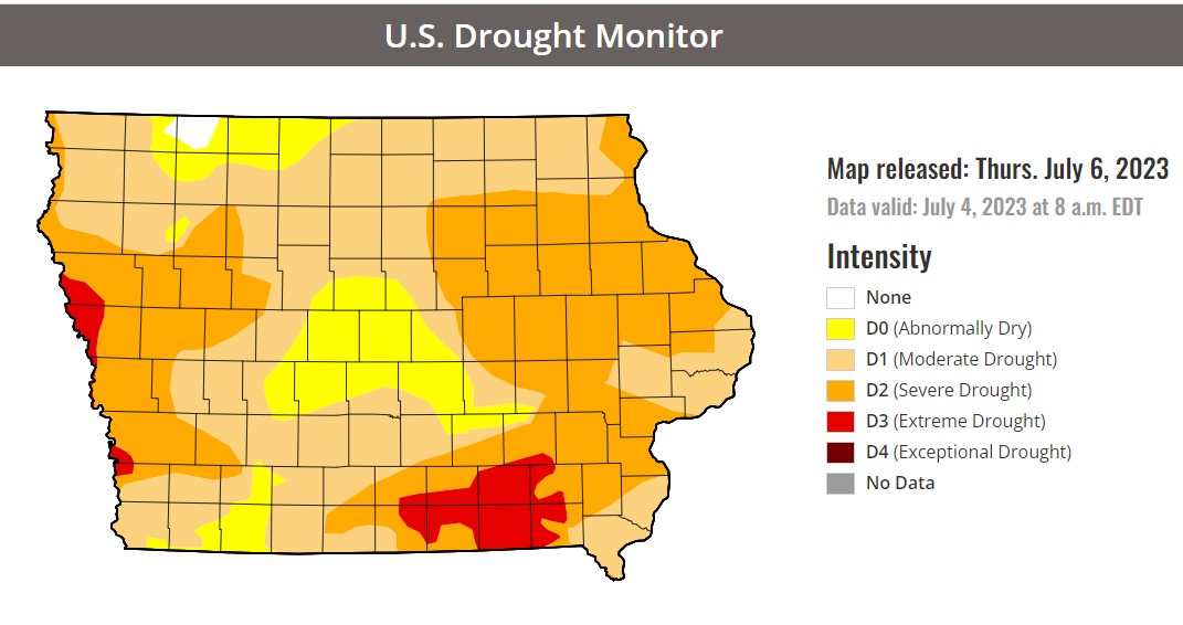
During June, which is typically Iowa’s wettest month, Iowa got less than three inches of rainfall statewide. About five-and-a-half inches would’ve been normal. (Click on the map to enlarge)
Today: Showers and thunderstorms before noon, then showers likely and possibly a thunderstorm between noon and 2pm, then a chance of showers and thunderstorms after 2pm. High near 71. East southeast wind 8 to 10 mph. Chance of precipitation is 80%. New rainfall amounts between a half and three quarters of an inch possible.
Tonight: A chance of showers and thunderstorms before 3am, then a slight chance of showers. Mostly cloudy, with a low around 55. East wind 7 to 9 mph becoming north northeast after midnight. Chance of precipitation is 40%. New rainfall amounts between a quarter and half of an inch possible.
Tomorrow: Partly sunny, with a high near 76. North northeast wind 7 to 9 mph.
Sunday: Sunny, with a high near 80.
Monday: Sunny, with a high near 85.
Thursday’s High in Atlantic was 77. Our Low this morning, 53. Last year on this date, the High in Atlantic was 84, and the Low was 72. The Record High was 107 in 1937. The Record Low was 41 in 1934. Sunrise is at 5:53. Sunset is at 8:56.
Today: Sunny, with a high near 75. North wind 3 to 8 mph.
Tonight: A 20 percent chance of showers and thunderstorms after 4am. Partly cloudy, with a low around 54. North wind around 6 mph becoming light and variable.
Friday: A 50 percent chance of showers and thunderstorms, mainly after 7am. Mostly cloudy, with a high near 75. Southeast wind 8 to 11 mph. New rainfall amounts between a tenth and quarter of an inch, except higher amounts possible in thunderstorms.
Friday Night: A 30 percent chance of showers and thunderstorms, mainly before 1am. Mostly cloudy, with a low around 57. Southeast wind around 9 mph becoming north northeast after midnight. New rainfall amounts of less than a tenth of an inch, except higher amounts possible in thunderstorms.
Saturday: Partly sunny, with a high near 77.
Sunday: Mostly sunny, with a high near 80.
(Radio Iowa) – You may have missed it over the long holiday weekend, but the experts confirm a rare derecho (dah-RAY-cho) blasted across far southeastern Iowa last Thursday. It was relatively minor compared to the derecho that swept over Iowa in August of 2020 which is considered the most costly thunderstorm in U-S history. State climatologist Justin Glisan says last week’s powerful, long-lasting wind storm began forming in northeast Missouri and caused plenty of damage across Iowa and two other states. “We saw several rounds of severe weather across southern Iowa including the start of a derecho which occurred in southeastern Iowa and then flowed through Illinois and Indiana,” Glisan says.
Wind gusts in that corner of Iowa exceeded 100-miles an hour, toppling trees and power lines and damaging roofs. Two people were reported hurt in the storm in Illinois. Glisan says the derecho put a severe end to a relatively calm month of June for Iowa. “Temperatures averaged right around 71 degrees,” he says, “and that’s a little over a degree above average with warmer conditions across the northwestern part of the state.” Iowa is seeing drought conditions worsen, week by week, and he says June brought little help — and little rainfall. “In terms of precipitation, rainfall, hail, June is the wettest month climatologically for much of the state,” Glisan says, “and we were definitely below average, just slightly under three inches statewide, and that’s about 2.4 inches below average.”

State Climatologist Justin Glisan
The long-range forecasts indicate July may not be as hot as we’re used to in Iowa. “We’re actually seeing an elevated signal for cooler temperatures across much of the upper Midwest and that’s surrounding and centralized on Iowa, which is a good signal to see on the precipitation side as well, above average chances of wetter conditions.”
The latest map from the U-S Drought Monitor shows only parts of two counties in northwest Iowa are seeing normal moisture levels, while the rest of the state is abnormally dry or experiencing drought, ranging from moderate to severe to extreme. Those extreme drought conditions are in far western Iowa and in south-central and southeast Iowa.
Atlantic-.04″ (at KJAN)
Early this morning: A 50 percent chance of showers and thunderstorms. Cloudy, with a steady temperature around 68. West northwest wind around 7 mph. New rainfall amounts of less than a tenth of an inch, except higher amounts possible in thunderstorms.
Today: A 40 percent chance of showers and thunderstorms, mainly before 3pm. Cloudy, then gradually becoming mostly sunny, with a high near 75. North wind 7 to 13 mph, with gusts as high as 18 mph. New rainfall amounts of less than a tenth of an inch, except higher amounts possible in thunderstorms.
Tonight: Mostly clear, with a low around 51. North wind 7 to 10 mph.
Thursday: Sunny, with a high near 76. North wind 7 to 9 mph.
Friday: A chance of showers, with thunderstorms also possible after 1pm. Mostly cloudy, with a high near 73. Chance of precipitation is 50%. New rainfall amounts of less than a tenth of an inch, except higher amounts possible in thunderstorms.
Saturday: A slight chance of showers and thunderstorms. Partly sunny, with a high near 80. Chance of precipitation is 20%.
Tuesday’s High in Atlantic was 90. Our Low this morning, 66. We received .04″ rain at the KJAN studios, overnight. Last year on this date, the High in Atlantic was 94, and the Low was 69. The Record High was 107 in 1911. The Record Low was 41 in 1972. Sunrise is at 5:51. Sunset is at 8:57.
(Radio Iowa) – The U-S-D-A’s weekly report on Iowa crops shows 61 percent of the state’s corn is rated good or excellent, a slight improvement from last week and soybean conditions rose to 53 percent good or excellent. The southern third of Iowa had above average rainfall last week. Topsoil moisture levels statewide are 17 percent very short and the subsoil ratings are even drier.
Last Thursday’s Drought Monitor shows parts of two counties in northwest and southwest Iowa are in extreme drought and in southeast Iowa, extreme drought conditions are reported in all or parts of seven counties.
Today (Independence Day): Sunny, with a high near 92. South wind 5 to 10 mph.
Tonight: Increasing clouds w/a 70% chance of showers and thunderstorms. Low around 64. S/SW winds becoming northerly at 5-10 mph. New rainfall amounts between a quarter and half of an inch possible.
Wednesday: Showers & thunderstorms, otherwise partly-to-mostly sunny. High near 75. N @ 10-20 mph. New rainfall amounts between a tenth and quarter of an inch, except higher amounts possible in thunderstorms.
Wednesday Night: Mostly clear, with a low around 52.
Thursday: Sunny, with a high near 76.
Friday: A 20 percent chance of showers after 1pm. Partly sunny, with a high near 78.
Monday’s High in Atlantic was 88. Our Low was 62. Last year on this date, the High in Atlantic was 94, and the Low was 72. The Record High was 111 in 1936. The Record Low was 41 in 1967. Sunrise is at 5:51. Sunset is at 8:57.


