
(Atlantic, Iowa) – A severe thunderstorm moved through the area early yesterday (Wednesday) morning. Emergency Management Coordinator Mike Kennon says although there were no reported injuries, widespread damages were evident. Winds in excess of 70 mph knocked down trees, large limbs and created some property damages with power outages. Strong winds also laid down field corn in areas.
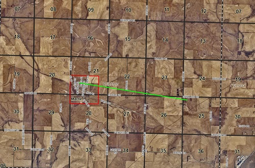
While performing Damage Assessments, Kennon noticed that some damages were more severe, very concentrated and seemed to run in a line. A drone was deployed and found that his suspicions were correct. There is a clear path of damage that runs along 4th Street in Marne to a cattle feeding operation at 580th and Eastland Road and ends southeast of the intersection of Eastland Road and 590th. This line is nearly 3 miles long. Similar damage was also noticed in the City of Cumberland and in a couple of other rural locations in Cass County.
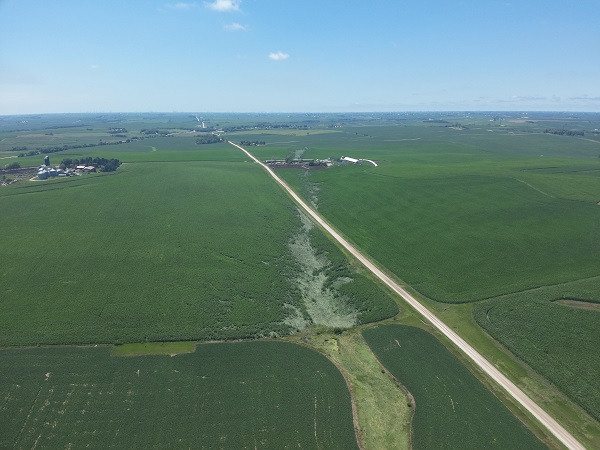
Drone picture taken by Cass County Sheriff’s Deputy, Ben Bartholomew.
Mike Kennon was interested in what the National Weather Service thought of this, so he submitted pictures and the drone video footage for their evaluation. Rod Donovan of the NWS-Des Moines said, “ It certainly appears there may have been some spin up circulations along the leading edge of the storm. Likely the radar beam started overshooting these features, so they were quite shallow features.”
The National Weather Service does not currently plan to perform a preliminary storm survey at this time.
[Council Bluffs, Iowa] – Emergency Management officials in Pottawattamie County are requesting the public report damages incurred to residential and business properties, as a result of the Wednesday, July 12th severe storms. The storms produced significant winds throughout the county, causing scattered structural damage, downed trees and power lines.
Pott. County Emergency Management Coordinator Doug Reed says “Although it doesn’t currently appear that a request for a disaster declaration is likely, we want to make sure we have as much data as possible before making that final decision. Other local or state-level assistance programs may be available to qualifying property owners depending on the amount or concentration of damage reports received.”

Pott. County EMA
Property owners can report their damage at pcema-ia.org. The system will ask for location and damage information as well as photos of the damage. Damage reports will be accepted through the end of the business day on Friday, July 13th.
Today: Areas of fog before 10am. Otherwise, partly sunny, with a high near 87. Southwest wind 5 to 11 mph.
Tonight: A 30 percent chance of showers and thunderstorms, mainly between 3am and 4am. Partly cloudy, with a low around 65. South southwest wind around 7 mph.
Tomorrow: A 50 percent chance of showers and thunderstorms. Partly sunny, with a high near 85. South southwest wind 8 to 11 mph becoming west northwest in the afternoon. New rainfall amounts of less than a tenth of an inch, except higher amounts possible in thunderstorms.
Saturday: Sunny, with a high near 85.
Sunday: A 30 percent chance of showers and thunderstorms, mainly after 1pm. Sunny, with a high near 85.
Wednesday’s High in Atlantic was 84. We received .29″ of rain during the day (with .12″ received prior to 7-a.m., for a total of .41″). Our Low was 60. Last year on this date the High was 88 and the Low was 58. The Record High on this date was 108 in 1936. The Record Low was 44 in 1897. Sunrise is at 5:57-a.m. Sunset is at 8:53-p.m.


(Will be updated as reports come in)
Numerous reports from across southwest and western Iowa, as well as eastern Nebraska, of trees and power lines down.
7:30-a.m., Union County EMA reports an estimated 50 mph gust of wind in Creston.
7:17-a.m., 65 mph wind gust reported by the public, 1 mile north of Fontanelle.
7:05-a.m., tree down across the road near Cumberland (location unclear)
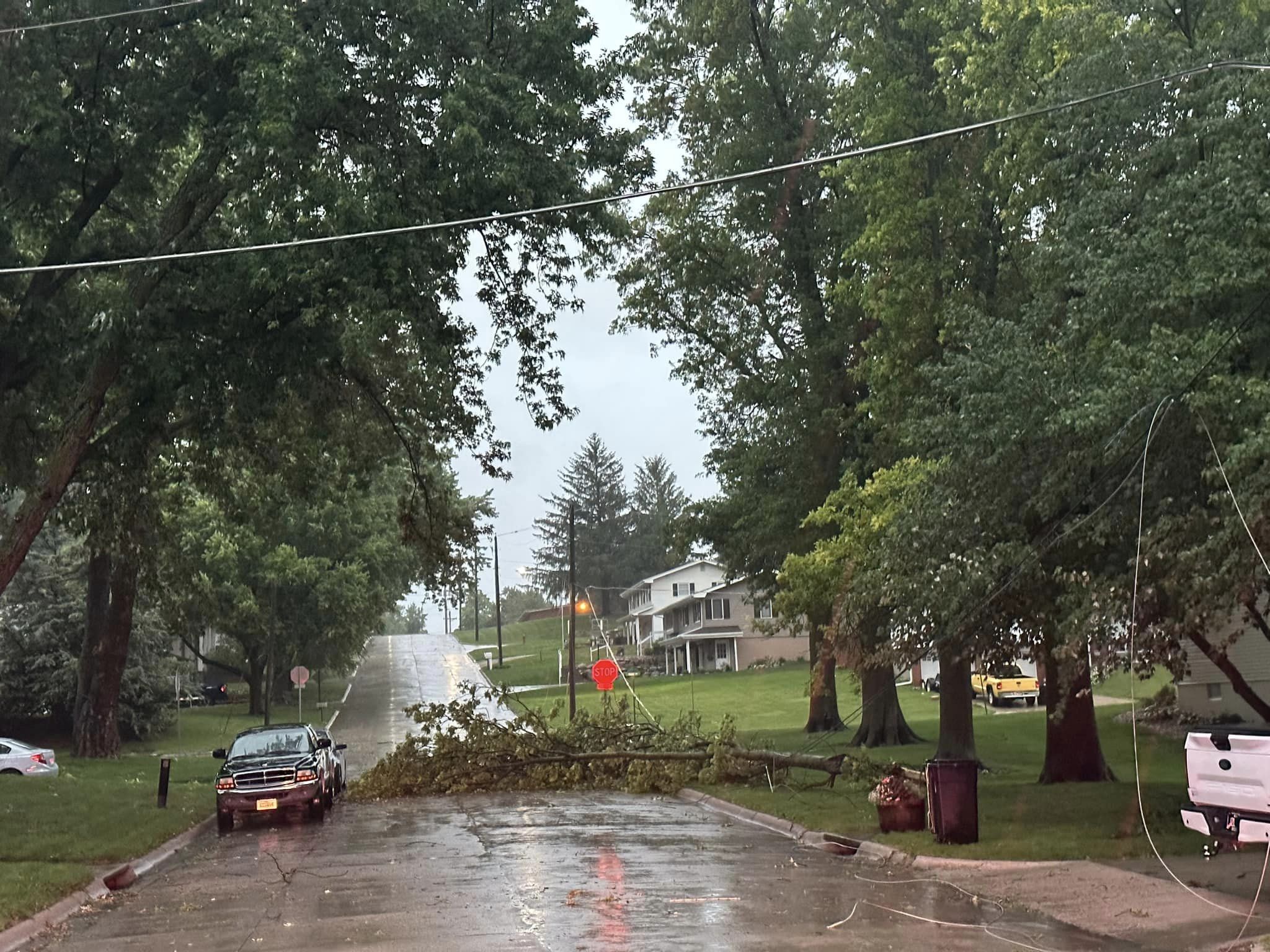
7:10-a.m. Tree down across the road at 3rd and Linn, in Atlantic.

3rd & Linn in Atlantic (Lori Murphy, photo)
7:16-a.m., Atlantic Fire dispatched for a tree fire along Hwy 71, just south of Memphis Road; Fire out now (7:26-a.m.). Tree down across the power line.
7:12-a.m, Power outage reported in SW/SE Atlantic by residents.
7:12-a.m., Tstm Wind Gust in Corning estimated at 70 mph (report from the Public)
6:38-a.m., Multiple trees damaged in Council Bluffs.
6:17-a.m., Thunderstorm wind damage 3 miles E/SE of Council Bluffs. Roof blown-off the Titan Hill Intermediate School.
6:12-a.m., Hail just under the size of pennies reported in Earlham.

Montgomery County EMA photo
Montgomery County EMA photo
Today: Strong to severe thunderstorms are possible early this morning. The main hazards will be damaging wind gusts, though hail and locally heavy rainfall are also possible; Showers and thunderstorms through mid-day. Some of the storms could produce heavy rainfall. High near 84. East southeast wind 10 to 15 mph becoming west this afternoon. New rainfall amounts between 1 and 2 inches possible.
Tonight: Partly cloudy, with a low around 64. Northwest wind 5 to 10 mph becoming northeast after midnight.
Tomorrow: Mostly sunny, with a high near 88. West wind 5 to 10 mph.
Tom. Night: A 50% chance of showers and thunderstorms, mainly after midnight. Low around 64.
Friday: A 50% chance of showers and thunderstorms, otherwise Mostly sunny, with a high near 83.
Saturday: Sunny, with a high near 85.
Tuesday’s High in Atlantic was 90. Our Low was 67. As of 7-a.m. (24-hour precip.) rainfall in Atlantic was .12″. Last year on this date the High was 85 and the Low was 56. The Record High on this date was 106 in 1939. The Record Low was 47 in 1895 & 1975. Sunset was at 5:56-a.m. Sunset is at 8:54-p.m.
Today: Mostly sunny, with a high near 87. North northeast wind 5 to 10 mph becoming south southeast in the afternoon.
Tonight: A round of strong to severe thunderstorms begins tonight. The main hazards will be damaging wind gusts, hail, and locally heavy rainfall. Low around 67. East wind 5 to 10 mph. New rainfall amounts between 1 and 2 inches possible.
Wednesday: Showers and thunderstorms likely, mainly before 7am. Partly sunny, with a high near 86. SE winds @ 5-10 becoming northerly in the afternoon. New rainfall amounts between a quarter and half of an inch possible.
Thursday: Mostly sunny, with a high near 86.
Friday: A 40 percent chance of showers and thunderstorms. Mostly sunny, with a high near 83.
Monday’s High in Atlantic was 85. Our Low this morning was 65. Last year on this date the High was 85 and the Low was 59. The Record High on this date was 104 in 1936. The Record Low was 43 in 1895. Sunset was at 5:55-a.m. Sunset is at 8:54-p.m.
Today: Sunny, with a high near 87. Southwest wind 10-20 mph.
Tonight: Partly cloudy w/a 30% chance of showers and thunderstorms. Low around 63. S/SW @ 5-15 w/gusts to near 20. New rainfall amounts of less than a tenth of an inch, except higher amounts possible in thunderstorms.
Tuesday: A slight chance of showers, otherwise mostly sunny. High near 87. NW @ 5-10 mph.
Tue. Night: Showers and thunderstorms likely. Some of the storms could produce heavy rain. Low 63. New rainfall amounts between 1 and 2 inches possible.
Wednesday: Partly sunny, w/a 50% chance of showers and thunderstorms. High near 83. New rainfall amounts between a tenth and quarter of an inch, except higher amounts possible in thunderstorms.
Wednesday Night: Partly cloudy, with a low around 64.
Thursday: Mostly sunny, with a high near 86.
Sunday’s High in Atlantic was 82. Our Low this morning, 52. Last year on this date the High was 87 and the Low was 70. The Record High on this date was 104 in 1930 & 1936. The Record Low was 46, in 1895 & 1996. Sunset is at 5:55-a.m. Sunset is at 8:55-p.m.
Today: Sunny, with a high near 82. Calm wind becoming west northwest around 6 mph in the morning. Tonight: Clear, with a low around 59. West wind 5 to 7 mph becoming south after midnight.
Monday: Sunny, with a high near 87. South southwest wind 10 to 15 mph, with gusts as high as 18 mph.
Monday Night: A 40 percent chance of showers and thunderstorms. Mostly clear, with a low around 64. South southwest wind 7 to 13 mph. New rainfall amounts of less than a tenth of an inch, except higher amounts possible in thunderstorms.
Tuesday: A 30 percent chance of showers and thunderstorms, mainly after 1pm. Sunny, with a high near 88. South southeast wind 6 to 9 mph. New rainfall amounts of less than a tenth of an inch, except higher amounts possible in thunderstorms.
Tuesday Night: Showers and thunderstorms likely, mainly after 1am. Some of the storms could produce heavy rainfall. Mostly cloudy, with a low around 64. Chance of precipitation is 70%. New rainfall amounts between 1 and 2 inches possible.
Wednesday: A chance of showers and thunderstorms before 1pm, then a slight chance of showers. Mostly sunny, with a high near 83. Breezy. Chance of precipitation is 40%.
Saturday’s High in Atlantic was 77. Our Low this morning, 50. Last year on this date the High was 87 and the Low was 67. The Record High on this date was 104 in 1930. The Record Low was 37, in 1895. Sunset was at 5:54-a.m. Sunset is at 8:55-p.m.


