
Today: Mostly cloudy w/a 50% chance of showers & thunderstorms this morning. A strong to severe storm with quarter
sized hail is possible. Gradually becoming sunny, with a high near 91. West wind 5 to 15 mph becoming south southeast this afternoon, & gusting to around 20 mph. New precipitation amounts between a tenth and quarter of an inch, except higher amounts possible in thunderstorms.
Tonight: Partly cloudy, with a low around 67. East southeast wind 6 to 9 mph.
Tomorrow: Partly sunny, with a high near 92. South southeast wind 6 to 9 mph.
Tom. Night: A 20 percent chance of showers and thunderstorms after 1am. Mostly cloudy, with a low around 71. East southeast wind 8 to 10 mph.
Wednesday: Sunny, with a high near 96.
Thursday: Sunny and hot, with a high near 97.
Sunday’s High in Atlantic was 88. Our Low was 59. We received .28″ rain this morning (Between 5:45-and 6:45-a.m.). Last year on this date, the High temperature in Atlantic was 86 & the Low was 59. The Record High was 110 in 1901. The Record Low was 42 in 1905. Sunrise today was at 6:06. Sunset is 8:45.
Today: Mostly sunny, with a high near 90. N/NW breeze @ 5-10-mph.
Tonight: P/Cldy w/a slight chance of showers after midnight. Low around 65.
Monday: A 20% chance of showers and thunderstorms, otherwise mostly sunny, with a high near 91. S @ 10-20.
Tuesday: Mostly sunny, with a high near 92. South wind 7 to 10 mph.
Wednesday: Mostly sunny, with a high near 93.
Saturday’s High in Atlantic was 87. The Low was 56. Last year on this date, the High temperature in Atlantic was 95 & the Low was 68. The Record High was 105 in 1901. The Record Low was 45 in 1904 & 1956. Sunrise today was at 6:05. Sunset is 8:46.
Friday’s High in Atlantic was 88 and this morning’s low 60. This day last year the high was 91 and the low 58. The record high for Sept. 2nd in Atlantic was 101 set in 2000 and the record low was 30 degrees set in 1893. Sunrise is at 6:47 am and sunset is at 7:52 pm.
Click to enlarge this map
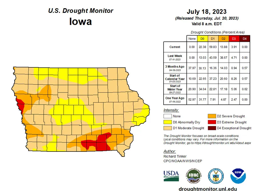
(Radio Iowa) – The new map from the U-S Drought monitor show some slight improvement following rains across the state. All of the state still has some sort of drought rating, but the area that was in extreme drought dropped below four percent in the last week. The severe drought areas dropped from nearly 39 percent to less than 14 percent. With those percentages dropping, nearly 60 percent of the state is now in moderate drought, and around 22 percent is abnormally dry. The worst drought conditions remain in northwest and southeast sections of the state.
Today: Mostly sunny, with a high near 81. Calm wind becoming north 5 to 7 mph in the morning.
Tonight: A 20 percent chance of showers and thunderstorms after 10pm. Partly cloudy, with a low around 61. North northwest wind around 6 mph becoming calm.
Saturday: A 30 percent chance of showers and thunderstorms, mainly after 1pm. Mostly sunny, with a high near 85. Southwest wind 5 to 8 mph becoming west northwest in the afternoon. New rainfall amounts of less than a tenth of an inch, except higher amounts possible in thunderstorms.
Saturday Night: A 20 percent chance of showers and thunderstorms before 1am. Partly cloudy, with a low around 61. West northwest wind 5 to 7 mph becoming south after midnight.
Sunday: Sunny, with a high near 87.
Sunday Night: Mostly clear, with a low around 63.
Monday: Mostly sunny, with a high near 91.
Thursday’s High in Atlantic was 82. Our Low this morning, 56. Last year on this date the High was 91 and the Low was 63. The Record High was 107 in 1934, and the Record Low was 44 in 1894. Sunrise is 6:03-a.m. Sunset is 8:48-p.m.
Today: Sunny, with a high near 81. North northwest wind 5 to 13 mph, with gusts as high as 20 mph.
Tonight: Partly cloudy, with a low around 59. North wind 5 to 9 mph.
Tomorrow: Mostly sunny, with a high near 80. Northwest wind 3 to 8 mph.
Saturday: A chance of showers and thunderstorms before 10am, then a chance of showers between 10am and 1pm, then a slight chance of showers and thunderstorms after 1pm. Sunny, with a high near 84. Chance of precipitation is 30%.
Sunday: Sunny, with a high near 87.
Wednesday’s High in Atlantic was 83. The Low was 62. Last year on this date the High was 89 and the Low was 58. The Record High was 109 in 1934, and the Record Low was 44 in 1953. Sunrise is 6:02-a.m. Sunset is 8:49-p.m.
Today: A 20 percent chance of showers and thunderstorms after 3pm. Partly sunny, with a high near 84. East southeast wind around 6 mph becoming light and variable.
Tonight: A 20 percent chance of showers and thunderstorms before midnight. Mostly cloudy, then gradually becoming mostly clear, with a low around 64. North northeast wind 5 to 7 mph becoming west northwest after midnight.
Thursday: Sunny, with a high near 81. North northwest wind 8 to 13 mph, with gusts as high as 18 mph.
Friday: Mostly sunny, with a high near 80. North northwest wind 5 to 9 mph.
Saturday: A 20 percent chance of showers and thunderstorms after 2pm. Sunny, with a high near 83.
Sunday: Sunny, with a high near 87.
Tuesday’s High in Atlantic was 79. The Low was 59. Last year on this date the High was 92 and the Low was 62. The Record High was 110 in 1934, and the Record Low was 47 in 1891 & 1947. Sunrise is 6:02-a.m. Sunset is 8:49-p.m.
Today: A 50 percent chance of showers and thunderstorms, mainly before 1pm. Cloudy, then gradually becoming mostly sunny, with a high near 77. East wind 5 to 10 mph. New rainfall amounts between a tenth and quarter of an inch, except higher amounts possible in thunderstorms.
Tonight: Partly cloudy, with a low around 61. East wind around 6 mph.
Wednesday: A 20 percent chance of showers and thunderstorms after 1pm. Partly sunny, with a high near 83. East southeast wind 5 to 7 mph becoming west northwest in the afternoon.
Thursday: Sunny, with a high near 80.
Friday: Sunny, with a high near 80.
Monday’s High in Atlantic was 76. We received .06″ rain. Our Low was 54. Last year on this date the High was 86 and the Low was 61. The Record High was 107 in 1936, and the Record Low was 44 in 1953. Sunrise is 6:01-a.m. Sunset is 8:51-p.m.
(Radio Iowa) – Smoke from the Canadian wildfires is being swept out of the state. John Gering of the Iowa Department of Natural Resources has looked at the latest map. “It does appear to be a north to south clearing,” he says. This latest round of smoke had settled at the surface level. That’s why alerts indicated air quality has been unhealthy for sensitive groups. “If it stays up high in the atmosphere, it’s not going to affect people and it’s not going to register on our monitors,” Gering says, “so it’s that combination of emissions, horizontal winds and vertical mixing.” The Iowa D-N-R’s STATEWIDE air quality alert ends at noon today (Monday). The alert has recommended that people reduce long or intense outdoor activities due to the fine particulates in the air.
“They’re about 30 times smaller than the diameter of a human hair,” Gering says, “so they get in your lungs and your lungs have a hard time expelling the small particles.” The fires carry chemicals which in the presence of sunlight form ozone, an odorless gas. Over the past five years, there have been an average of three to four air quality warnings related to high ozone concentrations in Iowa at ground level. By June 12th, there had been 124 — so that does not include this weekend’s conditions.
“Likewise we’ve had 22 exceedences of the fine particulate matter standard reported through July 12,” Gering says, “and there’s going to be some additional exceedences of that standard coming in, rolling in over the next few weeks.” Staff collect filters at monitors throughout the state and take them to the University of Iowa where they are manually weighed. Gering says that process takes a while, so the in-depth analysis of this weekend’s air quality won’t be completed for a couple of weeks.


