
Today: Patchy fog before 8am. Otherwise, sunny, with a high near 78. North northwest wind 5 to 7 mph.
Tonight: Mostly clear, with a low around 56. Light and variable wind becoming south around 6 mph in the evening.
Wednesday: Sunny, with a high near 85. Breezy, with a south southwest wind 9 to 18 mph, with gusts as high as 23 mph.
Wednesday Night: Mostly clear, with a low around 63. Breezy, with a south wind 10 to 18 mph becoming west northwest after midnight. Winds could gust as high as 29 mph.
Thursday: Sunny, with a high near 80. North northwest wind 8 to 13 mph, with gusts as high as 18 mph.
Thursday Night: Clear, with a low around 55.
Friday: Sunny, with a high near 84.
Yesterday’s high was 72 and the low was 53. This day last year the high was 69 and the low was 62. The all-time record high was 103 set in 1937. The record low was 40 set in 1929. Sunrise is 6:28 a.m. and sunset is 8:20 p.m.
Today: Mostly cloudy, with a high near 70. Windy, with a west northwest wind 10 to 15 mph increasing to 15 to 20 mph in the afternoon. Winds could gust as high as 30 mph.
Tonight: Mostly cloudy, then gradually becoming mostly clear, with a low around 53. Breezy, with a north wind 5 to 15 mph, with gusts as high as 25 mph.
Tuesday: Sunny, with a high near 78. Northwest wind 5 to 10 mph.
Tuesday Night: Mostly clear, with a low around 56. South wind 5 to 10 mph.
Wednesday: Sunny, with a high near 84. Breezy, with a south southwest wind 10 to 20 mph, with gusts as high as 25 mph.
Thursday: Sunny, with a high near 81.
Yesterday’s high was 78 and the low was 60. This day last year the high was 83 and the low was 60. The all-time record high was 107 set back in 1936 and the record low was 45 in 1929. Sunrise today is 6:27 a.m. and sunset is 8:21 p.m.
Today: Mostly cloudy w/a 50% chance of showers and thunderstorms. High near 80. East wind 5 to 10 mph becoming south in the afternoon, and gusting to near 20 mph. New rainfall amounts between a quarter and half of an inch possible.
Tonight: A 40 % chance of showers and thunderstorms. Low around 58. W/NW winds @ 10-20 mph. New rainfall amounts between a tenth and quarter of an inch, except higher amounts possible in thunderstorms.
Monday: Partly sunny & breezy, with a high near 73. W/NW winds 15-30 mph.
Tuesday: Sunny, with a high near 77.
Wednesday: Sunny & breezy, with a high near 84.
Saturday’s High in Atlantic was 87 and the low was 62. We received .25″ rain overnight (as of 7-a.m. today/24-hour rainfall). This day last year the high was 88 and the low was 56. The all-time record high was 101 set in 1913. The record low was 39 set in 1964. Sunrise is 6:26 a.m. and sunset is 8:23 p.m.
(Radio Iowa) – The new U-S Drought Monitor shows the areas of Iowa with extreme and severe drought dropped following recent rains. Iowa Ag Secretary Mike Naig says a lot of farmers are thankful for the rains. “You know, you’d still say, and then the drought monitor will still say, that we’re dry. And you know, 100 percent of the state of Iowa is in at least abnormally dry. And you’ve seen persistent drought in some places like along western Iowa, southeast Iowa, there’s a pocket. But once again, this year, we’ve seen timely rain,” Naig says.
He says the impact of the drought has not been totally washed away. “We’ve got some places in the state that certainly will, we’ll see some yield reduction because of that persistent dryness,” Naig says. “But as I’ve traveled the state, there’s a lot of places that look really good. So now’s when you need rain, you still need to finish this crop off. And it’s good to see a more active weather pattern.”

IA AG Sec Mike Naig (RI photo)
Naig was at the Iowa State Fair for its opening ceremonies Thursday. He touted the new “Choose Iowa” program. “This is something that the legislature funded this past year, it’s time for us as a state to have a branded program for Iowa-made, Iowa-raised, Iowa-grown products,” he says. “So you know, it’s everything from a farmer selling beef direct to a consumer or a vegetable producer who’s working with a restaurant working with a chef.” Naig says consumers have been asking for and want to consider local when they are buying food. “I see a lot of exciting opportunities here. And I think too, for small and beginning farmers, just more market opportunities for folks to sell. And again, consumers are going to win in this whole thing,” he says.
Food, beverages and other agricultural products that are grown, raised or made within Iowa and meet or exceed minimum criteria can carry the “Choose Iowa” logo.
Today: Sunny, with a high near 88. Southwest wind 5 to 7 mph.
Tonight: Mostly clear, with a low around 63. West southwest wind around 6 mph becoming light and variable.
Tomorrow: Sunny, with a high near 88. North northeast wind 5 to 7 mph.
Tom. Night: A 20 percent chance of showers and thunderstorms after 1am. Partly cloudy, with a low around 64. North northeast wind around 6 mph becoming southeast after midnight.
Sunday: A chance of showers and thunderstorms, then showers likely and possibly a thunderstorm after 1pm. Partly sunny, with a high near 82. Chance of precipitation is 70%. New rainfall amounts between a quarter and half of an inch possible.
Sunday Night: A 40 percent chance of showers and thunderstorms before 1am. Partly cloudy, with a low around 58. Breezy.
Monday: Sunny, with a high near 76. Breezy.
Thursday’s High in Atlantic was 83 and our low was 57. We received .15″ rain last night. This day last year the high in Atlantic was 91 and the low was 57. The all-time record High on Aug. 11th was 104 in 1894 and the record low was 40 in 1902. Sunrise is at 6:24 and sunset is 8:25.
(Radio Iowa) – The tree-planting program called Re-Leaf is holding a ceremony in Cedar Rapids this (Thursday) morning, marking the devastating derecho that swept across Iowa three years ago today. Winds peaked at 140 miles an hour and it was the most costly storm in U-S history. Cedar Rapids was especially hard hit, losing two-thirds of its canopy — or some 670-thousand trees. In this interview from August of 2020, state climatologist Justin Glisan said the storm started in southern South Dakota.
“The derecho itself held together for 770 miles over 14 hours before losing strength as it entered western Ohio,” Glisan says. Many Iowans had never even heard the term “derecho” before the powerful storm blasted across the state’s midsection, wiping out trees, power lines and crops. Three Iowans were killed, many were hurt. To be designated as a derecho, a storm must have a width of at least 60 miles and travel at least 400 miles. In this file interview, Dennis Todey, director of the U-S-D-A’s Midwest Climate Hub in Ames, said derechos are hard to predict. 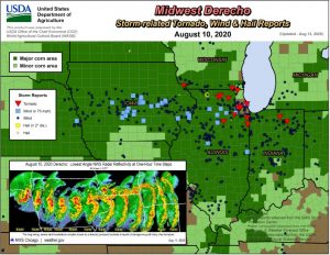
“Unfortunately, we can’t forecast these things too well in advance,” Todey says, “but once it set up and it was starting to look consistent, the Weather Service was right on top of it then and was doing warnings well ahead of it, letting people know this was a pretty nasty situation and had the potential for doing severe damage, which it did.” More than a half-million Iowa homes and businesses lost power during the storm, easily among the worst weather disasters for the state’s electric utilities. The governor declared 20 counties disaster areas. Todey says a derecho is very atypical to the storms Iowans are used to seeing during the summer months.

NWS photo near Shellsburg, August 10, 2020
“Unlike some thunderstorms which build up, rain out and then the cold air that spreads out from that shuts down the instability around a storm, this one is able to feed on itself,” Todey says. “The wind coming out ahead of it is able to lift warmer, moister air ahead of it and that keeps feeding back on that storm and maintain its strength all the way through.”
Derecho is a Spanish word that can be translated as direct or straight ahead. It was first coined by Dr. Gustavus Hinrichs at the University of Iowa in the late 1800s. Hinrichs, who started the first state weather service, is also among the researchers credited with the discovery of the atom and the Periodic Table of Elements.
Today: Areas of fog before 8am. Otherwise, mostly sunny, with a high near 84. Calm wind becoming south southwest 5 to 9 mph in the afternoon.
Tonight: A 40 percent chance of showers and thunderstorms, mainly between 10pm and 4am. Mostly cloudy, then gradually becoming mostly clear, with a low around 65. South wind 7 to 9 mph. New rainfall amounts between a tenth and quarter of an inch, except higher amounts possible in thunderstorms.
Friday: Sunny, with a high near 88. Southwest wind around 7 mph.
Saturday: Sunny, with a high near 86.
Sunday: Showers and possibly a thunderstorm. High near 80. Chance of precipitation is 80%.
Wednesday’s High in Atlantic was 81 and our low this morning, was 57. This day last year the high in Atlantic was 92 and the low was 56. The all-time record High on Aug. 10th was 105 in 1894 and the record low was 42 in 1967. Sunrise is at 6:23 and sunset is 8:27.


