
Tuesday: Sunny and hot, with a high near 100. Heat index values as high as 116. South southwest wind 10 to 13 mph.
Tuesday Night: Mostly clear, with a low around 76. South wind 11 to 16 mph, with gusts as high as 23 mph.
Wednesday: Sunny and hot, with a high near 102. Heat index values as high as 109. Southwest wind 9 to 14 mph, with gusts as high as 20 mph.
Thursday: Sunny and hot, with a high near 98. Southwest wind around 9 mph becoming north in the afternoon.
Friday: A slight chance of showers and thunderstorms before 1pm. Partly sunny, with a high near 86. North northeast wind 9 to 11 mph, with gusts as high as 18 mph.
Monday’s high was 94 and this morning’s low 68. This day last year the high was 83 and the low 56. The record high is 100 set in 1914 and the record low of 41 was set in 1904. Sunrise this morning at 6:36 am and sunset this evening is at 8:09 pm.
This could be the hottest week Iowans have endured in years, as near-record to record heat is likely. Forecasters say highs through Thursday will range from 95 to 105 degrees, with heat indices as high as 115. If the forecast holds, National Weather Service meteorologist Andrew Ansorge (an-SORE-ghee) says it will be the first time in a decade that August has had four or more consecutive days this hot in Des Moines.
Triple-digit temperatures are common in August, but he says highs are typically in the 80s by this late in the month. Southern California was just hit with its first tropical storm in more than 80 years, though it was a hurricane in the Pacific Ocean for a while. Ansorge says that’s one of the reasons temperatures will be near or above 100 degrees in Iowa most of this week, as the low pressure system is pushing record high heat from the Southwest to the Midwest.
All of Iowa is under an excessive heat warning through at least Wednesday night, and relief may not come until Friday. The National Weather Service says this may be Iowa’s hottest string of consecutive days since 2013. The service predicts above-normal temperatures until September.
An Excessive Heat Warning is in effect for all of the KJAN listening area until 9:00 pm Wednesday.
Today: Mostly sunny and hot, with a high near 97. Heat index values as high as 112. East southeast wind 6 to 10 mph becoming south in the afternoon.
Tonight: Clear, with a low around 75. South wind around 10 mph.
Tuesday: Sunny and hot, with a high near 102. Heat index values as high as 112. South southwest wind 9 to 13 mph.
Wednesday: Mostly sunny and hot, with a high near 102. Southwest wind 9 to 15 mph, with gusts as high as 23 mph.
Thursday: Mostly sunny and hot, with a high near 98. West southwest wind around 10 mph becoming north northeast in the afternoon. Winds could gust as high as 16 mph.
Friday: Mostly sunny, with a high near 85. North wind 10 to 15 mph, with gusts as high as 22 mph.
Sunday’s high was 92, this morning’s low is 68. This day last year the high was 83 and the low 56. The record high is 100 degrees set in 1936 and the record low is 40 set in 1956. Sunrise today is at 6:34 am. Sunset tonight is 8:11 pm. Tuesday’s sunrise is at 6:36 am.
Excessive Heat Warning
URGENT – WEATHER MESSAGE
National Weather Service Des Moines IA
939 AM CDT Sun Aug 20 2023
Audubon-Guthrie-Dallas-Polk-Jasper-Poweshiek-Cass-Adair-Madison-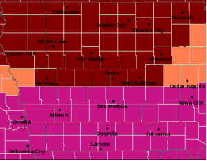
Warren-Marion-Mahaska-Adams-Union-Clarke-Lucas-Monroe-Wapello-
Taylor-Ringgold-Decatur-Wayne-Appanoose-Davis-
Including the cities of Audubon, Exira, Guthrie Center, Panora,
Bayard, Casey, Perry, Waukee, Adel, Des Moines, Newton, Grinnell,
Atlantic, Greenfield, Stuart, Adair, Fontanelle, Winterset,
Earlham, Indianola, Norwalk, Carlisle, Pella, Knoxville,
Oskaloosa, Corning, Creston, Osceola, Chariton, Albia, Ottumwa,
Bedford, Lenox, New Market, Mount Ayr, Lamoni, Leon, Corydon,
Seymour, Allerton, Humeston, Centerville, and Bloomfield
939 AM CDT Sun Aug 20 2023
…EXCESSIVE HEAT WARNING REMAINS IN EFFECT UNTIL 9 PM CDT
WEDNESDAY…
* WHAT…An extended period of dangerously hot conditions with
heat index values up to 114.
* WHERE…Much of the southern half of Iowa.
* WHEN…Until 9 PM CDT Wednesday.
* IMPACTS…Extreme heat and humidity will significantly
increase the potential for heat related illnesses,
particularly for those working or participating in outdoor
activities.
* ADDITIONAL DETAILS…The long duration of the heat can be
particularly hard on the very young, the elderly and those
with medical conditions.
PRECAUTIONARY/PREPAREDNESS ACTIONS…
Drink plenty of fluids, stay in an air-conditioned room, stay out
of the sun, and check up on relatives and neighbors. Young
children and pets should never be left unattended in vehicles
under any circumstances.
Take extra precautions if you work or spend time outside. When
possible reschedule strenuous activities to early morning or
evening. Know the signs and symptoms of heat exhaustion and heat
stroke. Wear lightweight and loose fitting clothing when
possible. To reduce risk during outdoor work, the Occupational
Safety and Health Administration recommends scheduling frequent
rest breaks in shaded or air conditioned environments. Anyone
overcome by heat should be moved to a cool and shaded location.
Heat stroke is an emergency! Call 9 1 1.
...EXCESSIVE HEAT WARNING REMAINS IN EFFECT UNTIL 9 PM CDT
WEDNESDAY for Cass, Audubon, Guthrie, Adair, Madison, Adams, Union, Taylor and Ringgold counties.
and until 10:00 p.m. Wednesday for Harrison, Shelby, Pottawattamie, Mills, Montgomery, Fremont, and Page Counties.
*An Excessive Heat Watch is in place until Wednesday evening for Crawford and Carroll Counties.*
*A Heat Advisory is in place for Monona County until Wednesday at 10:00 p.m.**

* WHAT...An extended period of dangerously hot conditions with
  heat index values up to 114.

* WHERE...Much of the southern half of Iowa.

* WHEN...Until 9 PM CDT Wednesday.

* IMPACTS...Extreme heat and humidity will significantly
  increase the potential for heat related illnesses,
  particularly for those working or participating in outdoor
  activities.

* ADDITIONAL DETAILS...The long duration of the heat can be
  particularly hard on the very young, the elderly and those
  with medical conditions.

PRECAUTIONARY/PREPAREDNESS ACTIONS...

Drink plenty of fluids, stay in an air-conditioned room, stay out
of the sun, and check up on relatives and neighbors. Young
children and pets should never be left unattended in vehicles
under any circumstances.

Take extra precautions if you work or spend time outside. When
possible reschedule strenuous activities to early morning or
evening. Know the signs and symptoms of heat exhaustion and heat
stroke. Wear lightweight and loose fitting clothing when
possible. To reduce risk during outdoor work, the Occupational
Safety and Health Administration recommends scheduling frequent
rest breaks in shaded or air conditioned environments. Anyone
overcome by heat should be moved to a cool and shaded location.
Heat stroke is an emergency! Call 9 1 1.
*Excessive Heat Warning in effect from August 19, 01:00 PM CDT until August 23, 09:00 PM CDT
*EXCESSIVE HEAT WATCH IS IN EFFECT FROM SATURDAY AFTERNOON
THROUGH MONDAY EVENING FOR CASS, CRAWFORD, CARROLL, AUDUBON,
GUTHRIE, ADAIR, MADISON, ADAMS, UNION, TAYLOR, AND RINGGOLD COUNTIES
*WATCH IN PLACE FOR ALL OTHER COUNTIES IN THE LISTENING AREA UNTIL WEDNESDAY EVENING*
* WHAT...Dangerously hot conditions with heat index values nearing
  105 or more possible for several days Saturday into next week.

* WHERE...Portions of south central and southwestern Iowa.

* WHEN...From Saturday afternoon through Monday evening.

* IMPACTS...Extreme heat and humidity will significantly
  increase the potential for heat related illnesses,
  particularly for those working or participating in outdoor
  activities.

* ADDITIONAL DETAILS...Hot conditions are expected to expand into
  northern Iowa by Monday and then likely extend further into
  next week across the entire area as well. Additional expansion
  of heat related headlines is very possible over most of the
  region as more certainty on coverage and duration is realized.
The final days of the Iowa State Fair promise to be sweltering, as Iowans are being warned about a late summer heat wave that’s approaching for the weekend. The past few evenings have felt almost like fall with lows in the 50s and 60s, but National Weather Service meteorologist Cory Martin says daytime high temperatures will be climbing again very soon.
Many of Iowa’s crops are at critical growth stages and Martin says there’s very little chance for rain, well into next week.
With high temps likely climbing into triple digits this weekend, Martin says it’s certainly possible the weather service will issue heat advisories, or even extreme heat warnings.
The long-range forecast indicates those high temperatures will last at least as far as next Tuesday, with the prediction of 95 degrees that day in Des Moines.


