
Today: Cloudy w/a 40% chance of rain. High near 47. East wind 10 to 20 mph. New precipitation amounts of less than a tenth of an inch are expected.
Tonight: Mostly cloudy w/a 20% chance of rain before 8pm. Low around 36. N/NE wind 10-20 mph.
Tomorrow: Mostly cloudy & breezy through mid morning, then gradual clearing. High near 45. N @ 15-30 mph.
Tom. Night: Mostly clear, with a low around 22. N/NW @ 5-15 becoming W/SW after midnight & gusting to near 20 mph.
Wednesday: Sunny & breezy, with a high near 55.
Thanksgiving Day: Mostly sunny & breezy, with a high near 42.
Friday: Mostly cloudy, with a high near 35.
Sunday’s High in Atlantic was 59. Our Low was 30. This day last year the high was 52 and the low 19. The record high for Nov. 20th in Atlantic was 75 in 1933. The record low was -1 in 1937 & 1985. Sunrise is at 7:14 am and sunset is at 4:57 pm. Rainfall overnight (thru 4:50-a.m. today) was just .02.”
Today: Mostly cloudy w/a 30% chance of rain, mainly after 5pm. High near 56. SW winds at 5-15 mph w/gusts to near 20.
Tonight: A 60% chance of rain overnight. Low around 41. E/SE winds around 10 mph. New precipitation amounts of less than a tenth of an inch are expected.
Tomorrow: Cloudy w/a 60% chance of rain through about Noon. High near 45. E winds @ 10-20 mph. New precipitation amounts of less than a tenth of an inch are expected.
Tom. Night: Mostly cloudy w/a slight chance of rain before midnight. Low around 33.
Tuesday: Mostly sunny, & windy with a high near 44. N/NW winds at 10-20 mph gusting to around 30.
Wednesday: Sunny, with a high near 48.
Saturday’s High in Atlantic was 65. Our Low was 21. This day last year the high was 31 and the low 12. The record high for Nov. 19th in Atlantic was 73 in 1930. The record low was -1 in 1914. Sunrise is at 7:13 am and sunset is at 4:57 pm.
Today: Sunny, with a high near 61. West wind 5 to 10 mph.
Tonight: Mostly clear, with a low around 34.
Sunday:Partly cloudy to cloudy with a chance of rain in the afternoon. High near 56. SE wind 5-to 10-mph w/gusts to near 20 mph.
Sunday Night: Cloudy, w/a 60% chance of rain after midnight. Low around 39. E/SE winds 10-20 mph. New precipitation amounts of less than a tenth of an inch are expected.
Monday: A 60% chance of rain through about Noon. Otherwise cloudy. High near 45. E/NE @ 10-20 mph. New precipitation amounts of less than a tenth of an inch are expected.
Monday Night: Mostly cloudy w/a slight chance of rain before midnight. Low around 32.
Tuesday: Mostly sunny & windy, with a high near 47.
Friday’s High in Atlantic was 52. Our Low was 21. This day last year the high was 26 and the low 11. The record high for Nov. 18th in Atlantic was 72 in 1999. The record low was 0 in 1891.
Today: Sunny, with a high near 49. North northeast wind 5 to 10 mph becoming light and variable.
Tonight: Clear, with a low around 28. South southwest wind 5 to 10 mph.
Tomorrow: Sunny, with a high near 60. West wind 5 to 10 mph.
Tom. Night: Partly cloudy, with a low around 35.
Sunday: Mostly cloudy w/a 30% chance of rain in the afternoon. High near 55. New precipitation amounts between a tenth and quarter of an inch possible.
Sunday Night: Cloudy &breezy,w/a 50% chance of rain. Low around 38.
Monday: Cloudy & breezy w/a 60% chance of rain through mid-day. High near 45.
Thursday’s High in Atlantic was 67. Our Low this morning was 23. This day last year the high was 34 and the low 11. The record high for Nov. 17th in Atlantic was 73 in 1941. The record low was -2 in 1959. Sunrise is at 7:11 am and sunset is at 4:59 pm.
(Radio Iowa) – Even though temperatures are in the 50s and 60s today (Thursday), there will be a time down the road, perhaps soon, when snow arrives in Iowa — and lots of it. Meteorologist Chad Hahn, at the National Weather Service in Johnston, says they’re launching new guidelines which stipulate how winter storm watches and warnings are issued, based on the amount of snow that’s predicted to fall.
For Iowa and all points north, Hahn says it’ll be six inches or more of snow, but as you go south, that criteria decreases to account for climatological differences. Hahn says the changes won’t be all that noticeable for the winter storm forecasts that are being issued in Iowa.
The old system used time restraints, so much snow over so many hours, and he says now, it’ll simply zero in on a winter event.
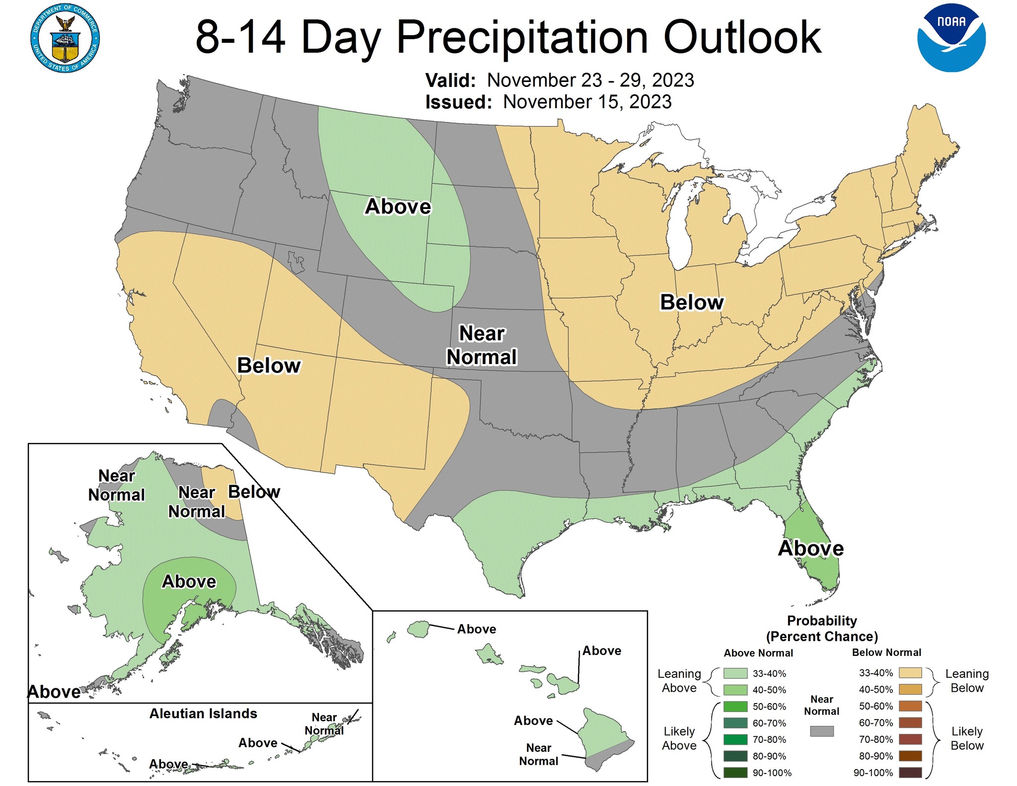
(Des Moines, Iowa) – The latest Iowa Drought Monitor was released this (Thursday) morning, showing both the Severe and Extreme Drought areas have expanded slightly. Unfortunately, there isn’t much help expected anytime soon. There are some light rain chances early next week, but the 8-to 14-day outlook is leaning toward below normal precipitation. (Click on the graphics to enlarge)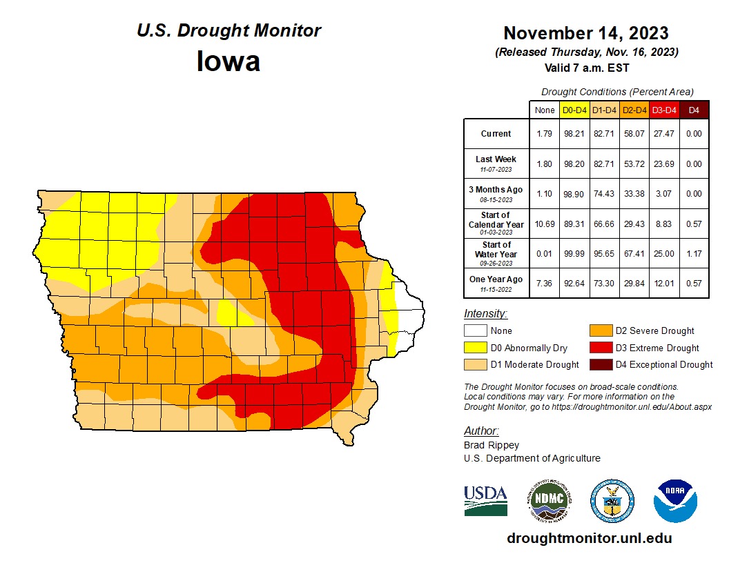
Area Counties: Sac-Crawford-Carroll-Audubon-Guthrie-Dallas-Cass-Adair-Madison-Adams-Union
1122 AM CST Thu Nov 16 2023
…Period of Gusty Winds Causing Elevated Fire Weather Conditions Today…
What…Breezy winds out of the southwest from 20 to 25 mph with gusts over 30 mph.
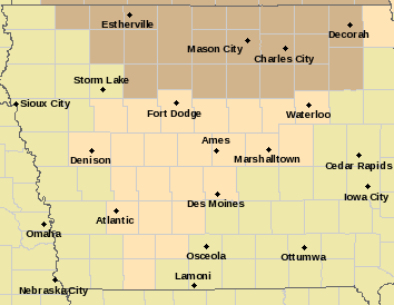
elevated fire weather (counties in flesh color); Wind Advisory for counties in brown.
When…Now until 3 pm
Impacts…Winds may cause fires to behave sporadically at times. Unsecured outdoor objects may be blown around and smaller tree branches may break.
Preparedness and Precautionary Actions…Use extra caution when driving, especially if operating a high profile vehicle.
Today: Partly sunny & windy. High near 65. S/SW winds @ 10-20 this morning gusting to near 40 this afternoon.
Tonight: Mostly cloudy w/a slight chance of rain this evening, then gradual clearing. Low around 29. W/SW winds 10-20 mph w/gusts as high as 25 mph. Chance of precipitation is 20%.
Tomorrow: Sunny, with a high near 47. North wind @ 5-10 mph becoming W/SW in the afternoon.
Tom. Night: Clear, with a low around 28. South southwest wind around 5 mph.
Saturday: Sunny, with a high near 58.
Saturday Night: Mostly clear, with a low around 32.
Sunday: Mo. Cldy w/a slight chance of rain after noon. High near 56.
Wednesday’s High in Atlantic was 69. The Low was 30. This day last year the high was 27 and the low 14. The record high for Nov. 16th in Atlantic was 73 in 2001. The record low was 1 in 1955. Sunrise is at 7:09 am and sunset is at 4:59 pm.
Today: Sunny, with a high near 69. Calm wind becoming southeast around 6 mph in the morning.
Tonight: Mostly clear, with a low around 45. South wind 6 to 13 mph, with gusts as high as 20 mph.
Tomorrow: Increasing clouds, with a high near 66. Windy, with a south southwest wind 14 to 24 mph, with gusts as high as 34 mph.
Tom. Night: Mostly cloudy, with a low around 29. Blustery, with a west southwest wind 13 to 16 mph becoming north in the evening. Winds could gust as high as 23 mph.
Friday: Sunny, with a high near 48.
Saturday: Sunny, with a high near 58.
Tuesday’s High in Atlantic was 69. The Low was 29. This day last year the high was 32 and the low 20. The record high for Nov. 15th in Atlantic was 75 in 2001. The record low was -7 in 1940. Sunrise is at 7:08 am and sunset is at 5:00 pm.
The National Weather Service issued a statement saying elevated fire weather conditions are expected…due to combination of windy conditions, low relative humidities, and cured agriculture fields and prairie grasses.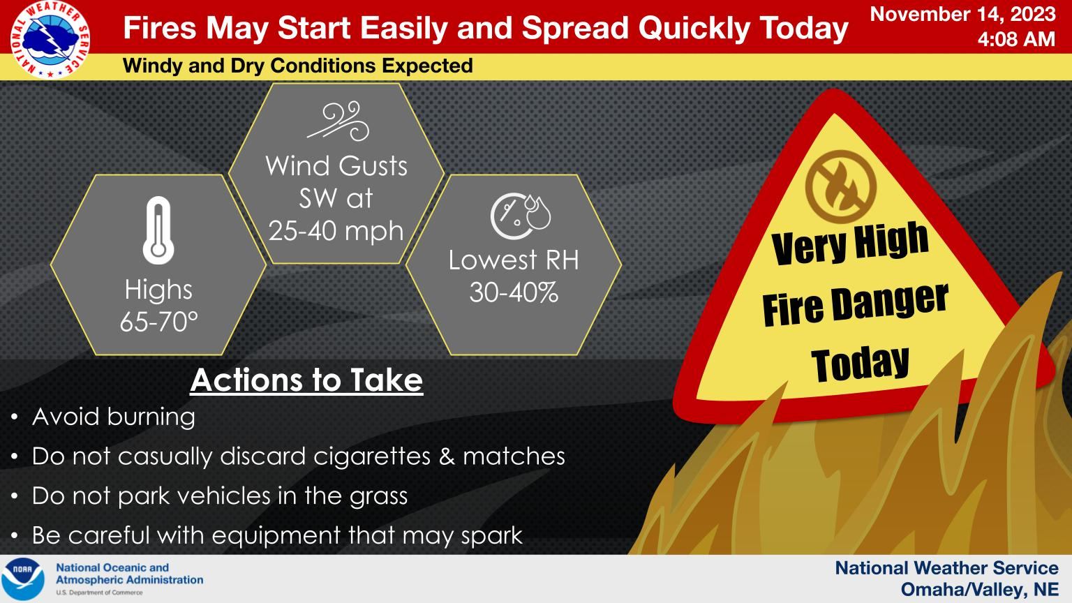 Strong and gusty winds, gusts up to 35 to 45 mph, will be experienced across eastern Nebraska and western Iowa today (Tuesday) through Thursday. Any fire that does start may spread quickly. The gusty winds may cause hazardous travel conditions for high profile vehicles on east west roadways, as well.


