
(Radio Iowa) – To some Iowans, it just isn’t the holiday season if there isn’t snow on the ground. If a white Christmas is on your wish list, you’ll have the best shot of finding flakes across Iowa’s northern-most counties. National Weather Service meteorologist Brad Small says they’ve studied the data spanning back decades and have compiled a map showing the probabilities of having snow on the ground on December 25th.
“Iowa can probably be generally weighted into four different tiers actually, with about a 60-plus-percent chance toward the Minnesota border, and then it steps down, Highway 20 corridor 50-percent, then 40, and then it gets down into the 30s as you get closer to the Missouri border,” Small says. “So it kind of behaves as you’d expect, with better chances the farther north you go.”
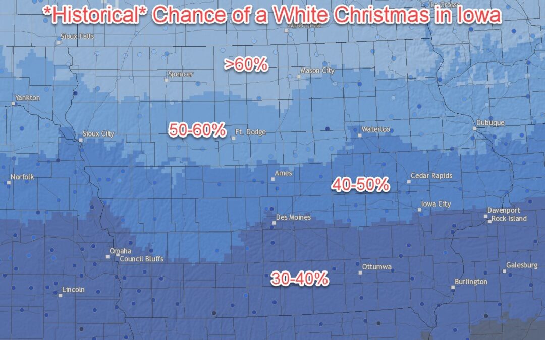
National Weather Service graphic
Since Christmas is still 19 days away, Small says it’s difficult to predict whether we’ll have a significant snowfall in Iowa by then. “It’s a little too far out to put too much on the end of the month,” Small says. “Probably the historical probabilities work better than anything else, at this point. There are some snow chances this weekend. Confidence in where that occurs and how much is pretty low, and it doesn’t look like to be a major system, so it’s potential, even if we do get snow this weekend, it could melt before Christmas.”
(Radio Iowa) – The weather is going to cooperate if you still have some outdoor work to do this week. National Weather Service meteorologist, Alexis Jimenez (hih-MEN-ezz), says temperatures are forecast to be double the norm. “Where our normal high temperatures are usually in the upper 30s around this time of year, we’re going to have temperatures reaching near 60 degrees, especially by Thursday. We can start seeing some records breaking,” she says.
The warmth will spread from the western side of the state. “The warmest will especially be in western Iowa on Wednesday, and Thursday it’s going to be much of Iowa will be near 60,” Jimenez says. If you are working outside, be prepared for windy conditions. “It’ll be a little bit breezy. The afternoon hours we’re expecting some gusts up to 30 miles per hour at times as we get through the middle part of the week,” she says. “So just be careful with that portion of the weather, but as far as temperatures go it’s gonna be pretty nice out there.”
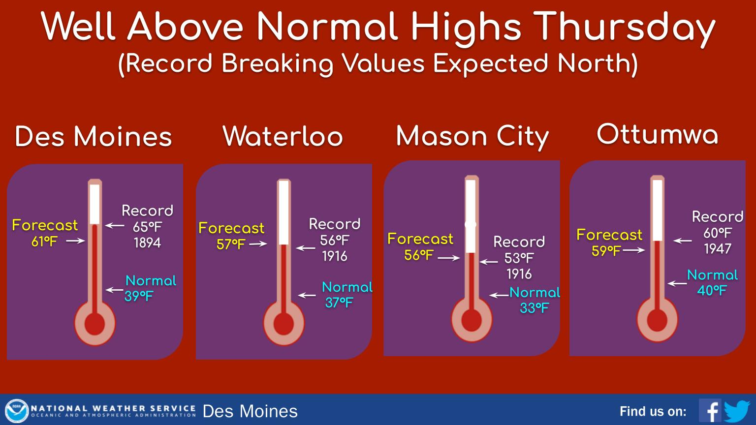 As is always the case with warm weather in December, enjoy it while you can. “Those warm temperatures will last up until we get a cold front moving through on Saturday, where our highs will fall back down into the upper 30s,” according to Jimenez.
She says there is a chance for some rain in southeast Iowa on Saturday, and maybe some snow chances on the backside of it there as well.
Today: Sunny & breezy, with a high near 52. S/SW wind 10-20 mph, with gusts to near 30 mph.
Tonight: Mostly clear, with a low around 33. S/SW @ 10-20 mph.
Tomorrow: Sunny & breezy, with a high near 60. S/SW @ 10-20 mph.
Tom. Night: Mostly clear, with a low around 34. S/SW @ 10 becoming west after midnight.
Friday: Partly sunny, with a high near 54.
Friday Night: Cloudy & windy w/a 40% chance of rain before 3am, then a chance of rain and snow. Low around 30.
Saturday: Mostly cloudy & windy w/a 30% chance of rain and snow, mainly before noon. High near 39.
Tuesday’s High in Atlantic was 41. The Low was 13. Last year on this date, the High in Atlantic was 44 and the Low was 14. The Record High on December 6th in Atlantic, was 69 in 2001. The Record Low was -12 in 2005. Sunrise is at 7:31. Sunset at 4:50.
Today: Mostly cloudy, then gradually becoming sunny. Breezy. High near 39. N/NW winds 5-15 mph w/gusts to 25.
Tonight: Mostly clear, with a low around 23.
Tomorrow: Mostly sunny & breezy, with a high near 50. S/SW wind 10-20 w/gusts to around 25 mph.
Tom. Night: Mostly clear, with a low around 34. S/SW wind 10-20 mph.
Thursday: Sunny & breezy, with a high near 60.
Thu. Night: Mostly clear & breezy, with a low around 34.
Friday: Mostly sunny, with a high near 53.
Monday’s High in Atlantic was 39. The Low was 26. We received a trace of snow Monday morning. Last year on this date, the High in Atlantic was 46 and the Low was 21. The Record High on December 5th in Atlantic, was 66, in 2001. The Record Low was -14 in 2005. Sunrise is at 7:30. Sunset at 4:50.
(Radio Iowa) – State Climatologist Justin Glisan says the initial, long-term forecast for December indicates warmer temperatures and more precipitation, but there’s nothing to suggest there’s an amped up threat of a tornado outbreak like the one two years ago. “December 15th, 2021, that was an extreme event,” Glisan says. “We had a serial derecho and 63 tornadoes — the largest tornado outbreak for Iowa for any month and the largest December outbreak for the United States in the observational record.”
The latest Drought Monitor nearly all of Iowa has some level of drought, with some areas in extreme drought. Glisan says there is the potential for more precipitation to fall in December, but the old adage that it’s too dry to rain is true in SOME cases when thunderstorms hit dry pockets of air. “We saw this in western Iowa as the drought started in May and June of 2020. You would have thunderstorms approach the state and then just either break up or go around because there was no low level moisture to work with,” Glisan says. “Now in these larger scale low pressure systems they’re able to have more access to large scale moisture pools and hence you do see wider spread snowfalls or rainfalls.”
The seasonal outlook indicates abnormally wetter conditions along the southern coast of the U-S and that may provide the moisture weather systems sweeping across Iowa draw from and generate rain or snow.
Today: Patchy fog between 9am and 10am. Otherwise, mostly cloudy, with a high near 42. Light and variable wind becoming S/SW @ 10-20 mph.
Tonight: Cloudy to Partly Cloudy. Low around 27. SW winds @ 10-15 becoming northwesterly after midnight & gusting to around 20 mph.
Tomorrow: Mostly cloudy through mid morning, then gradual clearing. High near 42. N/NW @ 15-25 mph.
Tom. Night: Mostly clear, with a low around 20.
Wednesday: Mostly sunny & breezy. High near 51. S/SW @ 10-20.
Wed. Night: Mostly clear & breezy, with a low around 35.
Thursday: Sunny & breezy, with a high near 59.
Sunday’s High in Atlantic was 39. The Low was 22. Last year on this date, the High in Atlantic was 46 and the Low was 20. The Record High on December 4th in Atlantic, was 66, in 1998. The Record Low was -8 in 1905. Sunrise is at 7:29. Sunset at 4:50.
Crawford-Carroll-Greene-Audubon-Guthrie-Cass-Adair-Adams-Union-
Taylor-Ringgold Counties…
552 AM CST Sun Dec 3 2023
…Reduced Visibility in Fog…
What…Fog with visibilities around or under a mile
Where…Portions of southwest Iowa
When…Now through mid-morning
Impacts…Drivers should be alert for reduced visibility at times.
Preparedness and Precautionary Actions…If driving this morning, please use low beam headlights.
Today: Mostly cloudy w/areas of fog this morning, and a 30% chance of snow later this afternoon. High near 41. South winds at 5 to 10 mph becoming light and variable this afternoon. Little or no snow accumulation is expected.
Tonight: Mostly cloudy w/a 30% chance of snow, mainly before 8pm. Little or no snow accumulation is expected. Low around 22.
Monday: Partly sunny. High near 42. W-NW wind @ 5 to 15 mph becoming S/SW in the afternoon w/gust to 20 mph.
Monday Night: Partly cloudy, with a low around 27.
Tuesday: Mostly sunny, with a high near 42. NW @ 10-20 mph.
Tuesday Night: Mostly clear, with a low around 21.
Wednesday: Mostly sunny & breezy, with a high near 53.
Saturday’s High in Atlantic was 37. The Low was 28. Last year on this date, the High in Atlantic was 31 and the Low was 8. The Record High on December 3rd in Atlantic, was 64, in 2017. The Record Low was -13 in 1919. Sunrise is at 7:28. Sunset at 4:50.
Friday’s High in Atlantic was 39. The Low was 20. Last year on this date, the High in Atlantic was 60 and the Low was 9. The Record High on December 2nd in Atlantic, was 65, in 2021. The Record Low was -10 in 1985. Sunrise is at 7:27. Sunset at 4:50.
(Atlantic, Iowa – KJAN) – Weather data for the month of November, 2023 in Atlantic, show the Average High for the month was 54, which was almost 10-degrees warmer than normal. The Average Low was 24, which was 3 degrees warmer than the norm. Rainfall for the month amounted slightly more than one-quarter of an inch (.28″), which was the result of combined rain and melted snow (2.0″). The total liquid value was nearly 1.6-inches below what we would typically receive during the month. The data was compiled at KJAN, the official National Weather Serving reporting site for Atlantic.
Looking ahead, we find the Average High for the month of December, in Atlantic, should be 33 degrees, while the Low should average out to 14. Precipitation (rain & or melted snow) is typically just 1.11 inches.
Weather data is compiled and recorded at KJAN, the official National Weather Service reporting site for Atlantic.


