
Today: [UPDATED] Mostly sunny, with a high near 51. Light south wind increasing to 6 to 11 mph in the morning.
Tonight: Mostly cloudy, with a low around 31. South wind around 7 mph.
Friday: A 20 percent chance of rain after noon. Mostly cloudy, with a high near 49. South wind 5 to 10 mph.
Friday Night: A 30 percent chance of rain. Cloudy, with a low around 30. South southwest wind around 6 mph. New precipitation amounts of less than a tenth of an inch possible.
Saturday: A 20 percent chance of rain before noon. Partly sunny, with a high near 45.
Sunday: Sunny, with a high near 47.
Monday: Sunny, with a high near 41.
Wednesday’s High in Atlantic was 49. The Low was 17. Last year on this date, the High in Atlantic was 34 and the Low was 26. The Record High on December 14th in Atlantic, was 59 in 1975. The Record Low was -19 in 1901 & 1972. Sunrise is at 7:38. Sunset at 4:50.
Today: Mostly sunny, with a high near 46. S @ 5 mph this afternoon.
Tonight: Mostly clear, with a low around 25. South southeast wind around 5 mph.
Tomorrow: Mostly sunny, with a high near 51. South wind 5 to 10 mph.
Tom. Night: Mostly cloudy, with a low around 30. South wind 5 to 10 mph.
Friday: Mostly cloudy, with a high near 49.
Friday Night: Mostly cloudy w/a 20% chance of rain. Low around 32.
Saturday: Partly sunny, with a high near 44.
Tuesday’s High in Atlantic was 39. The Low was 16. Last year on this date, the High in Atlantic was 45 and the Low was 28. The Record High on December 13th in Atlantic, was 65 in 1921. The Record Low was -20 in 1961. Sunrise is at 7:37. Sunset at 4:50.
Today: Increasing clouds, with a high near 37. North wind 5 to 10 mph.
Tonight: Cloudy w/a 20% chance of snow before 3am. Low around 23. E/SE wind around 5 mph.
Tomorrow: Sunny, with a high near 45. East wind 5 to 10 mph becoming south in the afternoon.
Tom. Night: Mostly clear, with a low around 24. South southeast wind around 5 mph.
Thursday: Mostly sunny, with a high near 48.
Thu. Night: Mostly cloudy, with a low around 31.
Friday: Mostly cloudy, with a high near 47.
Monday’s High in Atlantic was 50. The Low was 17. Last year on this date, the High in Atlantic was 38 and the Low was 30. The Record High on Dec. 12th was 62 in 1921 & 1968. The Record Low was -20 in 1932. Sunrise 7:36. Sunset 4:50.
Today: Sunny, with a high near 45. Light and variable wind becoming west southwest 5 to 7 mph in the morning.
Tonight: Mostly clear, with a low around 20. West southwest wind 6 to 8 mph becoming north northwest after midnight.
Tomorrow: Partly sunny, with a high near 35. North northwest wind 5 to 8 mph.
Tom. Night: Mostly cloudy, with a low around 22. Light and variable wind becoming southeast around 6 mph after midnight.
Wednesday: Partly sunny, with a high near 42.
Thursday: Mostly sunny, with a high near 49.
Sunday’s High in Atlantic was 43. The Low was 16. Last year on this date, the High in Atlantic was 38 and the Low was 16. The Record High on December 11th in Atlantic, was 64 in 1965. The Record Low was -14 in 1917. Sunrise is at 7:36. Sunset at 4:50.
Today: Increasing clouds, with a high near 39. Northwest wind 5 to 10 mph becoming south southwest in the afternoon.
Tonight: Partly cloudy, with a low around 19. Southeast wind around 6 mph.
Monday: Sunny, with a high near 44. East southeast wind 5 to 8 mph becoming west southwest in the afternoon.
Monday Night: Partly cloudy, with a low around 23. Southwest wind 6 to 9 mph becoming north northwest after midnight.
Tuesday: Partly sunny, with a high near 37. North northwest wind 6 to 9 mph.
Tuesday Night: Mostly cloudy, with a low around 18.
Wednesday: Mostly sunny, with a high near 41.
Saturday’s High in Atlantic was 38. We received a trace of snow (just a light dusting). The Low was 19. Last year on this date, the High in Atlantic was 39 and the Low was 15. The Record High on December 10th in Atlantic, was 58 in 1891. The Record Low was -14 in 1917. Sunrise is at 7:35. Sunset at 4:50.
(National Weather Service) – Breezy winds out of the northwest will gust 30 to 45 mph throughout the rest of the afternoon, tapering off this evening. This may result in loose objects such as holiday decorations being blown around. It may also make for difficult travel with high profile vehicles, especially during periods of light snow which may reduce visibility at times.
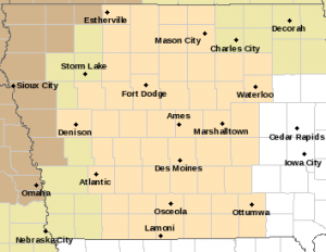
Special Weather Statement for counties in flesh color on this map: Wind Advisory for counties in light brown. https://www.weather.gov/dmx/
..WIND ADVISORY IN EFFECT UNTIL 6 PM CST THIS EVENING FOR HARRISON COUNTY in the KJAN listening area.
* WHAT…Northwest winds 20 to 25 mph with gusts up to 40 mph.
* IMPACTS…Gusty winds will blow around unsecured objects. Tree limbs could be blown down and a few power outages may result.
PRECAUTIONARY/PREPAREDNESS ACTIONS…
Winds this strong can make driving difficult, especially for high profile vehicles. Use extra caution.
Secure outdoor objects.
Friday’s High in Atlantic was 56 (6 degrees shy of tying the record High). The Low was 33. Last year on this date, the High in Atlantic was 37 and the Low was 32. The Record High on December 9th in Atlantic, was 62 in 1946 and 2020. The Record Low was -17 in 1917 & 2005. Sunrise is at 7:35. Sunset at 4:50.
(Radio Iowa) – It’s pretty rare Iowans get to run around in sweatshirts or light jackets in December, but unseasonably warm weather settled on the state late this week. Meteorologist Rod Donavon, at the National Weather Service, says Lamoni had the state’s hot spot with a record high temperature of 62-degrees on Thursday, one of many. “We did have several record highs, including Waterloo at 57, Mason City at 55, Ottumwa at 61,” Donavon says. “In addition, we had basically this entire area was in the upper 50s to low 60s, so a very mild day and well above normal.”
Today’s (Friday) forecast calls for cooler weather than yesterday, but still very comfortable for this time of year. “We are having a few more clouds passing across the state today,” Donavon says, “so it’s still going to be pretty mild high temperatures in the 50s, which is still within that 10- to 15-degree above-normal range.”
Much colder weather will move in tonight and overnight, bringing the chance of scattered rain or light snow across various parts of the state on Saturday. Highs for the weekend will be back around normal, in the 30s and 40s.
Today: Increasing clouds, with a high near 54. West wind 5 to 10 mph.
Tonight: Cloudy to partly cloudy, with a low around 31. W/NW wind 10-20 mph.
Tomorrow: Mostly cloudy & windy. High near 38. W/NW @ 15-25 mph.
Tom. Night: Partly cloudy & blustery, with a low around 19. NW @ 10-20 w/gusts to around 25 mph.
Sunday: Sunny, with a high near 38.
Sunday Night: Partly cloudy, with a low around 20.
Monday: Sunny, with a high near 44.
Thursday’s High in Atlantic was 61 (3 degrees shy of tying the record High). The Low was 37. Last year on this date, the High in Atlantic was 38 and the Low was 25. The Record High on December 8th in Atlantic, was 67 in 1946. The Record Low was -18 in 1917 & 1976. Sunrise is at 7:33. Sunset at 4:50.
Today: Sunny, with a high near 60. South wind 8 to 15 mph, with gusts as high as 21 mph.
Tonight: Mostly clear, with a low around 34. South wind 7 to 11 mph becoming west after midnight. Winds could gust as high as 18 mph.
Friday: Increasing clouds, with a high near 54. West wind 6 to 9 mph becoming north in the afternoon.
Friday Night: A chance of rain before midnight, then a slight chance of rain and snow. Mostly cloudy, with a low around 29. West northwest wind 7 to 13 mph, with gusts as high as 20 mph. Chance of precipitation is 30%. Little or no snow accumulation expected.
Saturday: Partly sunny, with a high near 39. Breezy.
Saturday Night: Partly cloudy, with a low around 19. Blustery.
Sunday: Mostly sunny, with a high near 38.
Wednesday’s High in Atlantic was 53. The Low was 29. Last year on this date, the High in Atlantic was 44 and the Low was 14. The Record High on December 7th in Atlantic, was 64 in 1894. The Record Low was -15 in 2005. Sunrise is at 7:32. Sunset at 4:50.


