
Today: A 40 percent chance of rain, mainly before 10am. Patchy fog before 1pm. Otherwise, mostly cloudy, with a high near 52. Light and variable wind becoming southwest around 6 mph in the morning. New precipitation amounts of less than a tenth of an inch possible.
Tonight: Mostly cloudy, with a low around 37. Calm wind becoming south around 5 mph after midnight.
Saturday: Partly sunny, with a high near 56. Light south wind increasing to 8 to 13 mph in the morning. Winds could gust as high as 18 mph.
Sat. Night: A 50 percent chance of rain, mainly after midnight. Cloudy, with a low around 44. Breezy, with a south southeast wind 10 to 16 mph, with gusts as high as 24 mph. New precipitation amounts between a tenth and quarter of an inch possible.
Sunday: Rain. High near 53. Breezy. Chance of precipitation is 100%. New precipitation amounts between a half and three quarters of an inch possible.
Sunday Night: Rain. Low around 38. Breezy. Chance of precipitation is 80%.
Christmas Day: Rain likely. Mostly cloudy, with a high near 47. Breezy. Chance of precipitation is 70%.
Monday Night: Rain likely, mainly before midnight. Cloudy, with a low around 31. Blustery. Chance of precipitation is 70%.
Thursday’s High in Atlantic was 55. The Low was 42. We received .02″ rain/drizzle over the past 24-hours (ending today at 7-a.m.). Last year on this date, the High in Atlantic was -10 and the Low was -14. The Record High on Dec. 22nd was 65 in 1933,and the Record Low was -27 in 1989. Sunrise is 7:42. Sunset is 4:52.
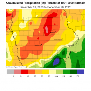
(Des Moines, Iowa) – The Iowa Department of Natural Resources says the current drought is the longest in Iowa since the 1950s, with abnormally dry and drought conditions extending into the 188th week in a row, according to the latest data available.Following the 16th driest November on record, precipitation for December is currently about 60 percent of average, which is normally 1.37 inches. Portions of southeast Iowa recorded above normal rainfall for the month, leaving most of the state with below average precipitation.
Depending on potential rainfall during the coming weekend, December could finish with average levels This would help stabilize, but not improve, drought conditions. Tim Hall, the Hydrology Resources Coordinator for the Iowa DNR, says “At this point, any moisture we get in the state will be helpful. With conditions as dry as they are coming out of 2023 there is a real concern for hydrologic conditions moving into 2024. Low stream flows and dry soil conditions could lead to water supply challenges in the coming year.”
 However, the dry winter months will make drought recovery challenging. January is normally the driest month of the year in the state, with an average of less than one inch of moisture. Iowa State Climatologist, Dr. Justin Glisan says “Strong El Niño conditions are projected to persist through winter. In an El Niño winter, precipitation can be highly variable. Warmer than normal temperatures could result in more rain than snow during the winter months.”
The Iowa Drought Team, made up of staff from the Departments of Homeland Security and Emergency Management, Agriculture and Land Stewardship, and Natural Resources will continue to meet over the winter months to prepare for potential continuation and worsening of drought conditions. The next Water Summary Update, which will include a review of the 2023 conditions, will be published in January.
Today: A 20 percent chance of rain after 5pm. Patchy fog between 8am and 10am. Otherwise, cloudy, with a high near 50. South wind 5 to 8 mph.
Tonight: A 50 percent chance of rain, mainly after 1am. Patchy fog after 1am. Otherwise, cloudy, with a low around 43. South wind 3 to 6 mph. New precipitation amounts of less than a tenth of an inch possible.
Friday: A 40 percent chance of rain before noon. Areas of fog before 1pm. Otherwise, mostly cloudy, with a high near 51. South wind around 6 mph becoming west southwest in the afternoon. New precipitation amounts of less than a tenth of an inch possible.
Friday Night: Mostly cloudy, with a low around 37. Calm wind becoming south around 6 mph after midnight.
Saturday: Partly sunny, with a high near 55.
Saturday Night: Rain likely, mainly after midnight. Cloudy, with a low around 47. Breezy. Chance of precipitation is 60%.
Sunday: Rain and possibly a thunderstorm. High near 52. Breezy. Chance of precipitation is 90%.
Sunday Night: Rain, mainly before midnight. Low around 39. Chance of precipitation is 80%.
Christmas Day: Rain likely. Mostly cloudy, with a high near 48. Chance of precipitation is 70%.
Wednesday’s High in Atlantic was 49. The Low was 21. Last year on this date, the High in Atlantic was 21 and the Low was -11. The Record High on Dec. 21st was 5 in 1941,and the Record Low was -22 in 1989. Sunrise is 7:42. Sunset is 4:52.
Today: Increasing clouds, with a high near 48. Southeast wind 5 to 10 mph.
Tonight: Cloudy, with a low around 34. East southeast wind around 5-10 mph.
Tomorrow: Cloudy w/a slight chance of rain. High near 50. South southeast wind 5-10 mph.
Tom. Night: Cloudy w/a slight chance of rain. Low around 40.
Friday: Partly sunny. High near 55. S/SW @ 5.
Saturday: Mostly cloudy, with a high near 56.
Sunday: Cloudy & breezy, w/rain. High near 57.
Tuesday’s High in Atlantic was 48. The Low was 21. Last year on this date, the High in Atlantic was 12 and the Low was 0. The Record High on Dec. 20th was 61 in 1941,and the Record Low was -25 in 1901. Sunrise is 7:42. Sunset is 4:52.
Today: Mostly sunny, with a high near 44. Wind chill values as low as 10. Breezy, with a south wind 13 to 20 mph, with gusts as high as 38 mph.
Tonight: Mostly clear, with a low around 27. South wind 7 to 13 mph, with gusts as high as 23 mph.
Wednesday: Partly sunny, with a high near 50. South wind around 7 mph.
Wed. Night: Mostly cloudy, with a low around 36. Southeast wind 5 to 7 mph.
Thursday: A 20 percent chance of rain after noon. Mostly cloudy, with a high near 51.
Thu. Night: A 20 percent chance of rain before midnight. Mostly cloudy, with a low around 40.
Friday: Partly sunny, with a high near 55.
Monday’s High in Atlantic was 34. The Low was 13. Last year on this date, the High in Atlantic was 35 and the Low was 5. The Record High on December 19th in Atlantic, was 58 in 1966. The Record Low was -33 in 1983. Sunrise is at 7:41. Sunset is at 4:51.
Today: Sunny, with a high near 34. Breezy, with a north northwest wind 15 to 20 mph decreasing to 7 to 12 mph in the afternoon. Winds could gust as high as 26 mph.
Tonight: Mostly clear, with a low around 18. Wind chill values as low as 10. Light and variable wind becoming south 6 to 11 mph after midnight.
Tuesday: Partly sunny, with a high near 43. Wind chill values as low as 10. Breezy, with a south wind 14 to 20 mph, with gusts as high as 30 mph.
Wednesday: Mostly sunny, with a high near 49.
Thursday: Mostly cloudy, with a high near 52.
Sunday’s High in Atlantic was 43. Our Low this morning was 22. Last year on this date, the High in Atlantic was 27 and the Low was 4. The Record High on December 18th in Atlantic, was 66 in 1976. The Record Low was -28 in 1983. Sunrise is at 7:41. Sunset is at 4:51.
Today: Mostly cloudy, then gradually becoming sunny, with a high near 44. West southwest wind 7 to 14 mph becoming north northwest in the afternoon. Winds could gust as high as 21 mph.
Tonight: Mostly clear, with a low around 22. Blustery, with a north northwest wind 10 to 20 mph, with gusts as high as 31 mph.
Monday: Sunny, with a high near 33. Wind chill values as low as 10. Breezy, with a north northwest wind 8 to 18 mph, with gusts as high as 30 mph.
Monday Night: Mostly clear, with a low around 15. Wind chill values as low as 10. Light and variable wind becoming south 6 to 11 mph after midnight.
Tuesday: Partly sunny, with a high near 41. Breezy, with a south wind 13 to 18 mph, with gusts as high as 28 mph.
Tuesday Night: Partly cloudy, with a low around 29. Breezy.
Wednesday: Partly sunny, with a high near 50. Breezy.
Saturday’s High in Atlantic was 40. The Low was 30. We received .11″ rain/drizzle over the 24-hour period ending at 7-a.m. today (12/17). Total precipitation was .19″ from Friday through Saturday. Last year on this date, the High in Atlantic was 22 and the Low was 4. The Record High on December 17th in Atlantic, was 65 in 1939. The Record Low was -18 in 1951. Sunrise is at 7:40. Sunset is at 4:51.
Today: Mostly cloudy w/a 20% chance of rain early this morning; A 70% chance of rain later this afternoon. High near 45. South wind 5 to 10 mph. New precipitation amounts of less than a tenth of an inch possible.
Tonight: Rain. Low around 36. Light and variable wind becoming northwest 5 to 10 mph after midnight. New precipitation amounts between a quarter and half of an inch possible.
Saturday: Rain, mainly before noon. Steady temperature around 37. Northwest wind 10-20 mph, New precipitation amounts of less than a tenth of an inch possible.
Saturday Night: Partly cloudy, with a low around 24. Northwest wind 5 to 10 mph.
Sunday: Sunny, with a high near 44. Breezy.
Sunday Night: Mostly clear, with a low around 19. Blustery.
Monday: Sunny, with a high near 36. Breezy.
Monday Night: Mostly clear, with a low around 20.
Tuesday: Mostly sunny, with a high near 43. Breezy.
Thursday’s High in Atlantic was 55. The Low was 16. Last year on this date, the High in Atlantic was 27 and the Low was 19. The Record High on December 15th in Atlantic, was 72 in 2021. The Record Low was -19 in 1901. Sunrise is at 7:39. Sunset at 4:51.
Today: [UPDATED] Mostly sunny, with a high near 51. Light south wind increasing to 6 to 11 mph in the morning.
Tonight: Mostly cloudy, with a low around 31. South wind around 7 mph.
Friday: A 20 percent chance of rain after noon. Mostly cloudy, with a high near 49. South wind 5 to 10 mph.
Friday Night: A 30 percent chance of rain. Cloudy, with a low around 30. South southwest wind around 6 mph. New precipitation amounts of less than a tenth of an inch possible.
Saturday: A 20 percent chance of rain before noon. Partly sunny, with a high near 45.
Sunday: Sunny, with a high near 47.
Monday: Sunny, with a high near 41.
Wednesday’s High in Atlantic was 49. The Low was 17. Last year on this date, the High in Atlantic was 34 and the Low was 26. The Record High on December 14th in Atlantic, was 59 in 1975. The Record Low was -19 in 1901 & 1972. Sunrise is at 7:38. Sunset at 4:50.


