
(Radio Iowa) – Another winter storm is headed for Iowa but forecasters say it shouldn’t bring anywhere near as much snow as the two monster storms of last week. A Winter Weather Advisory is posted for most of Iowa from this (Thursday) afternoon through Friday morning. National Weather Service meteorologist Brad Small says this latest blast won’t drop the heavy, wet snow that caused so much consternation for Iowans in last week’s first winter wallop.
“It’ll be the light fluffy variety, probably amounting to about one-to-three inches before it’s done by late evening,” Small says. “The bad news is though, that will be followed by sharply increasing winds, not to the extent we saw with the previous blizzard, but still sufficient to cause some blowing and drifting snow and low visibilities tonight and into early Friday morning.”
Small says it’s about to get really cold, again, though we just have to get through the weekend.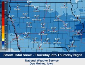
“We’re going to see lows well below zero, even in the teens below zero, depending on the part of the state you’re in, Friday night and Saturday night,” Small says. “It doesn’t look too long-lasting though. We should rebound next week for a period of above-normal temperatures. As a matter of fact, for starting the next work week, Monday morning, much of the state will probably be at freezing or just above.”Small says temperatures in the 30s next week will likely mean an end to the snow, at least temporarily, though it’s something of a trade-off.
“Just barely enough for a cold, miserable rain, nothing extreme, but it’ll be a soggy mess next week with melting snow and a little bit of rain on top of it,” Small says. “No travel impacts probably, but kind of a mess when we go the other direction after this snow and cold.” Parts of Iowa saw more than 25 inches of snow combined in last week’s two storms.
Today: Snow, mainly after 2pm. High near 17. Wind chill values as low as zero. Northeast wind 6 to 14 mph, with gusts as high as 18 mph. New snow accumulation of 1 to 3 inches possible. WINTER WEATHER ADVISORY REMAINS IN EFFECT FROM NOON TODAY TO 6 AM CST FRIDAY
Tonight: A 40% chance of snow, mainly before 8pm. Areas of blowing snow. Cloudy, then gradually becoming partly cloudy, with a low around -5. Wind chill values as low as -25. Blustery, with a northwest wind 14 to 18 mph, with gusts as high as 26 mph. New snow accumulation of less than a half inch possible. WIND CHILL ADVISORY REMAINS IN EFFECT FROM MIDNIGHT TONIGHT TO NOON CST FRIDAY
Friday: Areas of blowing snow before 9am. Mostly sunny and cold, with a high near 4. Wind chill values as low as -25. Northwest wind 11 to 14 mph, with gusts as high as 20 mph.
Saturday: Sunny and cold, with a high near 0.
Sunday: Partly sunny, with a high near 24. Windy.
Wednesday’s High in Atlantic was 21. The Low was 4. Last year on this date, the High in Atlantic was 35 and the Low was 29. The Record High for Jan. 18th in Atlantic, was 61 in 1951. The Record Low was -28, in 1984. Sunrise today: 7:43. Sunset: 5:18.


Today: A 20 percent chance of snow after 5pm. Mostly cloudy, with a high near 20. Wind chill values as low as -15. West southwest wind 5 to 8 mph becoming northeast in the afternoon.
Tonight: A 30 percent chance of snow, mainly before 11pm. Cloudy, with a low around 5. Wind chill values as low as -5. North northeast wind 3 to 7 mph. New snow accumulation of less than a half inch possible.
Tomorrow: Snow likely after noon. Mostly cloudy, with a high near 12. Wind chill values as low as -10. Northeast wind 7 to 13 mph. Chance of precipitation is 70%. New snow accumulation of 1 to 2 inches possible.
Tom. Night: A 20 percent chance of snow before midnight. Patchy blowing snow. Mostly cloudy, with a low around -7. Blustery, with a northwest wind 14 to 17 mph, with gusts as high as 23 mph.
Friday: Mostly sunny and cold, with a high near 3. Blustery.
Saturday: Sunny and cold, with a high near -1.
Tuesday’s High in Atlantic was 5. The Low was -9. Last year on this date, the High in Atlantic was 40 and the Low was 29. The Record High for Jan. 17th in Atlantic, was 57 in 1989. The Record Low was -21, in 1984. Sunrise today: 7:43. Sunset: 5:17.
Today: Sunny and cold, with a high near 6. W/SW winds 10-25 mph. Wind chill values as low as -35. **WIND CHILL WARNING until Noon today; WIND CHILL ADVISORY from Noon today until 9-a.m. Wednesday**
Tonight: Mostly clear, with a temperature falling to near -2 by 9pm, then rising to around 4 during the remainder of the night. SW winds 10-20. Wind chill values as low as -20.
Wednesday: Partly sunny, with a high near 17. W/SW winds 5-10 becoming northerly. Wind chill values as low as -10.
Thursday: Snow likely after noon. Mostly cloudy, with a high near 11. Chance of precipitation is 60%.
Friday: Mostly sunny and cold, with a high near 2. Blustery.
Monday’s High in Atlantic was -3. The Low was -9. Last year on this date, the High in Atlantic was 52 and the Low was 32. The Record High for Jan. 16th in Atlantic, was 64 in 1990. The Record Low was -25, in 2009. Sunrise today: 7:44. Sunset: 5:16.
(Radio Iowa) – Snow is NOT in Iowa’s forecast — until late Wednesday and Thursday. Meteorologist Allan Curtis at the National Weather Service office in the Des Moines metro says it will be nothing like what Iowa has endured over the past few days. “Certainly not 10 inches of snow like we saw the last couple of storm,” Curtis says. The National Weather Service reports 25-and-a-half (25.5) inches of snow fell in the Quad Cities from Monday through Friday of last week. Dubuque recorded 24-point-seven inches of snow during the same period. Nearly two feet fell in Waterloo from Monday through Friday. Those are all record amounts for a five day period. Curtis says the snow that has piled up will stay a while.
“Even if we got warm — 30 or 40 degrees — we would need at least a couple of weeks of that to make a real dent in the people’s general snow pack in their yards,” Curis says. “There are areas — edges of driveways, parking lots, rural areas — that have feet of snow and it’s going to take even longer for that, so for better or worse, I hope people are prepared to see this snow stick around for a number of weeks.” Today’s (Monday’s) high will below zero. By six o’clock, when tens of thousands of Iowans will be arriving at Caucus sites around the state, wind chills will flirt with 30 below zero.
“Really, the take away there is when traveling, please be careful because if you get stuck, that’s when the wind chill and the cold really become a concern for people,” Curtis says. “Just dress appropriately. Take your time.” There is a wind chill warning in effect for Iowa until noon on Tuesday.
Today (Monday) M.L.King Day: Mostly cloudy and cold, with a high near -3. W/NW winds 10-25 mph. Wind chill values as low as -35. **WIND CHILL WARNING continues until Noon Tuesday***
Tonight: Mostly clear, with a low around -15. W/NW winds 10-15. Wind chill values as low as -35.
Tomorrow: Sunny and cold, with a high near 4. W @ 10-20 mph. Wind chill values as low as -35.
Wednesday: Partly sunny, with a high near 18.
Thursday: A 30 percent chance of snow after noon. Partly sunny and cold, with a high near 9.
Sunday’s High in Atlantic was -9. The was -20. Last year on this date, the High in Atlantic was 48 and the Low was 33. The Record High for Jan. 15th in Atlantic, was 61 in 1990. The Record Low was -23, in 1905. Sunrise today: 7:44. Sunset: 5:15.
**WIND CHILL WARNING UNTIL NOON, TUESDAY**
Today: Mostly sunny and cold, with a steady temperature around -17. W/NW winds 10-25 mph. Wind chill values as low as -45.
Tonight: Mostly cloudy, with a low around -19. W/NW @ 10. Wind chill values as low as -35.
M.L.King Day: Mostly cloudy and cold, with a high near -5. W/NW @ 10-25 mph. Wind chill values as low as -30.
Monday Night: Partly cloudy, with a low around -15. W/NW @ 10-20 mph.
Tuesday: Sunny and cold, with a high near 5.
Tuesday Night: Mostly clear, with a low around -7.
Wednesday: Partly sunny, with a high near 17.
Saturday’s High in Atlantic was -1. Our Low this morning was -19. We received a trace of snowfall yesterday. Last year on this date, the High in Atlantic was 41 and the Low was 4. The Record High for Jan. 14th in Atlantic, was 54 in 1914. The Record Low was -29, in 1957. Sunrise today: 7:44. Sunset: 5:13.
Early this morning: Patchy blowing snow. Mostly cloudy, with a steady temperature around -1. Wind chill values as low as -25. Blustery, with a northwest wind around 18 mph, with gusts as high as 26 mph. BLIZZARD WARNING REMAINS IN EFFECT UNTIL 6 AM.
Today: A 40 percent chance of snow, mainly before 1pm. Patchy blowing snow. Mostly cloudy and cold, with a temperature falling to around -9 by 5pm. Wind chill values as low as -35. Windy, with a northwest wind 20 to 26 mph, with gusts as high as 37 mph. New snow accumulation of less than a half inch possible. WINTER WEATHER ADVISORY REMAINS IN EFFECT FROM 6 AM TO 6 PM CST SATURDAY; WIND CHILL WARNING REMAINS IN EFFECT UNTIL NOON CST TUESDAY.
Tonight: Patchy blowing snow before 2am. Mostly cloudy, with a low around -19. Wind chill values as low as -40. Windy, with a west northwest wind 15 to 23 mph, with gusts as high as 32 mph.
Sunday: Mostly sunny and cold, with a high near -10. Wind chill values as low as -40. West northwest wind 11 to 14 mph, with gusts as high as 20 mph.
M.L.King Day: Mostly cloudy and cold, with a high near -4. Blustery.
Tuesday: Sunny and cold, with a high near 1. Breezy.
Friday’s High in Atlantic was 10. Our Low this morning (24-hour Low ending at 7-a.m.), was -3. Snowfall from 7-a.m. Friday through 7-a.m. today amounted to 3.5-inches, for a total of 7.8 inches. Last year on this date, the High in Atlantic was 31 and the Low was 16. The Record High for Jan. 13th in Atlantic, was 62 in 1987. The Record Low was -24, in 1916. Sunrise today: 7:45. Sunset: 5:12.
Today: **Winter Storm Warning until 10-a.m., then a Blizzard Warning until 6-a.m. Saturday** Snow, mainly before 3pm. Widespread blowing snow, mainly between 3pm and 4pm. High around 10, with wind chill values as low as -15. N/NW winds 20-35 mph. New snow accumulation of 2 to 4 inches possible.
Tonight: Patchy blowing snow. Mostly cloudy, with a low around -5. NW @ 20-40 mph. Wind chill values as low as -25.
Saturday: Areas of blowing snow. High around Zero. NW @ 25-40 mph. Wind chill values as low as -35.
Saturday Night: Patchy blowing snow before 2am. Mostly cloudy, with a low around -17. NW @ 15-30 mph.
Sunday: Mostly sunny and cold, with a high near -8. Blustery.
Sunday Night: Mostly cloudy, with a low around -20.
M.L.King Day: Partly sunny and cold, with a high near -5. Blustery.
Thursday’s High in Atlantic was 20. Our Low this morning (as of 7-a.m.) was 8. Snowfall as of 7-a.m. was 4-inches at KJAN. Last year on this date, the High was 27 and the Low was 16. The Record High for Jan. 12th in Atlantic, was 57 in 1961 & 1987. The Record Low was -37, in 1974. Sunrise today: 7:45. Sunset: 5:11.


