
(Iowa DNR Water Summary Update) – Drought watches have been issued for northwest and southeast Iowa following a winter marked by a lack of rain and snow, according to the latest Water Summary Update from the Iowa Department of Natural Resources. Iowa experienced a notably dry winter, with worsening drought conditions expanding across much of the state through February. This deterioration has resulted in the northwest and southeast drought regions of Iowa being placed under a drought watch. While seasonal streamflows currently remain within normal ranges, soil moisture levels continue to decline statewide.
Iowa’s preliminary statewide February precipitation totaled 0.38 inches, or 0.79 inches below normal. Monthly totals ranged from no accumulation at several southern and northwestern stations to 1.26 inches in New Hampton, with southeastern Iowa experiencing the driest conditions as precipitation measured between 0.75 and 1.75 inches. The preliminary statewide average temperature for February was 31.3 degrees, which is 7.2 degrees above normal.
The U.S. Drought Monitor (USDM) currently shows that most of Iowa is abnormally dry or experiencing drought conditions, with portions of southeast Iowa carrying a severe drought designation. According to Iowa’s Drought Plan, all drought regions saw conditions deteriorate in February as soil moisture remained critically dry due to growing moisture deficits and the resurgence of drought. 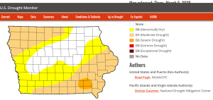
The National Weather Service’s Climate Prediction Center’s March outlook indicates above-average precipitation across the entire state, and an increased likelihood of above-average temperatures. The seasonal outlook suggests continued drought in far northwestern Iowa, and a drought-free or drought removal is likely for the remainder of the state.
“Following a winter of persistent moisture deficits, Drought Regions in northwest and southeastern Iowa are now under a drought watch. The lack of both precipitation and a significant snowpack has led to substantial soil drying across the state. While the seasonal outlook predicts drought will persist in far Northwest Iowa through May, the rest of the state shows a favorable trend for improvement,” said Jessica Reese McIntyre, DNR Environmental Specialist.
The report is prepared by technical staff from Iowa DNR, the Iowa Department of Agriculture and Land Stewardship, IIHR—Hydroscience and Engineering, and the U.S. Geological Survey, in collaboration with Iowa Homeland Security and Emergency Management Department.
Today: Sunny, with a high near 70. S/SW winds @ 5 to 10 mph becoming east in the afternoon.
Tonight: Mostly clear, with a low around 42.
Tomorrow: Mostly sunny, with a high near 65. NE wind 5 to 15 mph, with gusts as high as 20 mph.
Tom. Night: Mostly cloudy w/a 30% chance of rain, mainly after midnight. A low around 34. N/NE winds 10-25 mph.
Wednesday: A slight chance of rain or rain-snow mix in the morning; Becoming Partly sunny & windy. High around 50.
Wednesday Night: Mostly clear, with a low around 26.
Thursday: Partly sunny & windy, with a high near 61.
Sunday’s High in Atlantic was 70. The Low was 37. Last year on this date (March 9th), the High in Atlantic was 63 & the Low was 21. The Record High was 76 in 1986, & the Record Low was -10 in 1912. Sunrise: 7:42; Sunset: 7:19.
Today: Sunny & breezy, with a high near 68. Winds SW @ 10-to 25 mph.
Tonight: Mostly clear, with a low around 42. S/SW winds 15-to 25 mph.
Monday: Sunny, with a high near 71. Southwest wind around 10 mph.
Monday Night: Mostly clear, with a low around 45.
Tuesday: A slight chance of rain after 1pm, otherwise mostly sunny, with a high near 66. S winds @ 10-15 becoming northerly & gusting to near 20 mph.
Tue. Night: Rain changing to snow after midnight. A low around 34.
Wednesday: Snow-rain mix ending by 7-a.m.; Becoming Partly sunny & windy, with a high near 46.
Wednesday Night: Mostly clear, with a low around 25.
Saturday’s High in Atlantic was 49. We received a Trace of rain after 7-a.m. in the form of drizzle/mist. The Low was 30. Last year on this date (March 8th), the High in Atlantic was 51 & the Low was 21. The Record High was 76 in 1986, & the Record Low was -12 in 1982. Sunrise: 7:44; Sunset: 7:18.
From official National Weather Service spotter reports:
(NWS) – Severe storms that blew rapidly through parts of western Iowa and southeastern Nebraska, brought large hail to some locations. The National Weather Service in Valley, NE, said hail ranging in size from a quarter (1″ diameter) to ping pong ball-size hail (1.5″ in diameter) was reported to have fallen one-mile west of Blencoe, in Monona County between 8:40- and 8:45-p.m., Friday. Half-dollar size hail fell near Elliott, in Montgomery County, at around 6:12-p.m., and quarter-size hail fell near Emerson, in Mills County, at around 6:05-p.m.
Pea-to penny-size hail was reported in Dallas and Kossuth Counties in Iowa. Hail the size of quarters to golf ball-size fell in multiple areas in Nebraska, as well.
Through it all, there were no reports of damage or injuries.
Today: Cloudy & breezy through mid morning, then gradual clearing, with a high near 49. Winds NW @ 10-25 mph.
Tonight: Mostly clear, with a low around 33. S/SW winds 10-25 mph.
Sunday: Sunny & breezy, with a high near 64. SW winds 10-25 mph.
Sunday Night: Clear & breezy, with a low around 42.
Monday: Sunny, with a high near 68.
Tuesday: A slight chance of afternoon showers & thunderstorms after noon, otherwise mostly sunny, with a high near 64.
Wednesday: Partly sunny & breezy, with a high near 51.
Friday’s High in Atlantic was 71. We received .13″ rain at KJAN. The Low was 30. Last year on this date March 7th), the High in Atlantic was 37 & the Low was 19. The Record High was 78 in 2000, & the Record Low was -11 in 1982. Sunrise: 6:45; Sunset: 6:17.
TORNADO WATCH 16 IS IN EFFECT UNTIL 1000 PM CST FOR THE FOLLOWING LOCATIONS
IOWA COUNTIES INCLUDED ARE:
ADAIR ADAMS AUDUBON BOONE CALHOUN CARROLL CASS CLARKE DALLAS DECATUR FREMONT GREENE GUTHRIE HAMILTON MADISON MILLS MONTGOMERY PAGE POLK POTTAWATTAMIE RINGGOLD SHELBY STORY TAYLOR UNION WARREN WEBSTER.
* Primary threats include…
A few tornadoes and a couple intense tornadoes possible Scattered large hail likely with isolated very large hail events to 2 inches in diameter possible Scattered damaging wind gusts to 70 mph possible
SUMMARY…Severe storms are expected to develop near a northeast/southwest-oriented cold front, with additional development possible into this evening 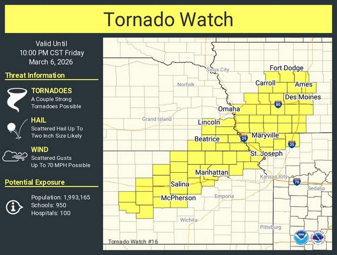
PRECAUTIONARY/PREPAREDNESS ACTIONS…
REMEMBER…A Tornado Watch means conditions are favorable for tornadoes and severe thunderstorms in and close to the watch area. Persons in these areas should be on the lookout for threatening weather conditions and listen for later statements and possible warnings.
Official NWS Spotter reports:
Other reports (from local media):
Cass County residents located 4 miles West & 7-miles SW of Atlantic, each reported 1.00″
SE of Bridgewater, 1.25″
Marne, 1.10″
Shenandoah, .97″
Clarinda, .80″
North of Neola, .60″
Stanton, 1.70″
Villisca, 1.00″
Lenox, .80″
Today: Showers and thunderstorms likely this morning & again later this afternoon. Some severe storms are possible late today. Large hail, damaging winds & isolated tornadoes are possible. A high near 68. Winds S/SW @ 10 to 25 mph. New rainfall amounts between a tenth and quarter of an inch, except higher amounts possible in thunderstorms.
Tonight: Showers and thunderstorms. Low around 31. Winds S @ 15-25 mph becoming NW after midnight. New precipitation amounts between a quarter and half of an inch possible.
Saturday: Mostly cloudy through mid morning, then gradual clearing. Breezy. A high near 50. NW @ 5-15 mph w/gusts to around 25.
Saturday Night: Mostly clear, with a low around 34. SW winds 10-20 mph.
Sunday: Sunny & breezy, with a high near 64.
Sunday Night: Mostly clear, with a low around 43.
Monday: Sunny, with a high near 67.
Thursday’s High in Atlantic was 58 (that was a 24-hour high, w/temps rising overnight into early this morning). We received .73″ rain overnight (thru 7-a.m. today), at KJAN. The Low was 42. Last year on this date (March 6th), the High in Atlantic was 38 & the Low was 13. The Record High was 76 in 2017, & the Record Low was -20 in 1960. Sunrise: 6:47; Sunset: 6:16.
Today: Cloudy through mid morning, then gradual clearing, with a high near 63. S/SE winds 5 to 10 mph in the afternoon.
Tonight: A chance of showers and thunderstorms after 11-p.m. Low around 48. New rainfall amounts between a quarter and half of an inch possible. A few of the storms could produce large hail.
Friday: Showers and some thunderstorms. High near 70. S/SW winds 15 to 25 mph. New rainfall amounts between a quarter and half of an inch possible. Large hail and damaging wind gusts will be possible, along with a few tornadoes mainly in southern Iowa.
Friday Night: Rain before 3am, then a slight chance of rain and snow. Some thunder is also possible. Low around 30. Little or no snow accumulation expected.
Saturday: Mostly sunny, with a high near 49.
Saturday Night: Clear, with a low around 33.
Sunday: Sunny, with a high near 64. Breezy.
Monday: Sunny, with a high near 71.
Wednesday’s High in Atlantic was 54. The Low was 39. Last year on this date (March 5th), the High in Atlantic was 26 & the Low was 12. The Record High was 74 in 1921, & the Record Low was -31 in 1960. Sunrise: 6:49; Sunset: 6:15.


