


Winter Storm & High Wind Watches in effect Sunday into part of Monday
March 14th, 2026 by Ric Hanson
Area Counties: Monona-Harrison-Shelby-Pottawattamie-Mills
WINTER STORM WATCH FROM SUNDAY MORNING THROUGH LATE SUNDAY NIGHT.
* WHAT…Blizzard conditions possible. Total snow accumulations between 1 and 3 inches possible. Winds could gust as high as 60 mph.
HIGH WIND WATCH FROM SUNDAY MORNING THROUGH LATE SUNDAY NIGHT...
* WHAT…Northwest winds 30 to 40 mph with gusts up to 60 mph possible.
Area Counties: Cass-Adair-Madison-Sac-Crawford-Carroll-Audubon-Guthrie-Dallas-Adams-Union-Taylor-Ringgold… 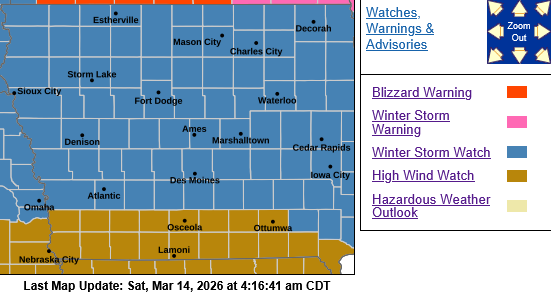
WINTER STORM WATCH IN EFFECT FROM SUNDAY MORNING THROUGH MONDAY MORNING…
* WHAT…Blizzard conditions possible. Total snow accumulations between 2 and 4 inches possible. Winds could gust as high as 60 mph.
Area Counties: Sac-Crawford-Carroll-Audubon-Guthrie-Dallas-Cass-Adair-Madison-Adams-Union-Taylor-Ringgold…
HIGH WIND WATCH IN EFFECT FROM SUNDAY AFTERNOON THROUGH LATE SUNDAY NIGHT...
* WHAT…North winds 30 to 40 mph with gusts up to 55-60 mph possible.
FOR THE WINTER STORM WATCH:
* IMPACTS…Roads, and especially bridges and overpasses, will likely become slick and hazardous. Visibilities may drop below 1/4 mile due to falling and blowing snow. Whiteout conditions are possible and may make travel treacherous and potentially life-threatening.
PRECAUTIONARY/PREPAREDNESS ACTIONS…
Prepare for possible blizzard conditions. Continue to monitor the atest forecasts for updates on this situation. Persons should consider delaying all travel. Motorists should use extreme caution if travel is absolutely necessary.
FOR THE HIGH WIND WARNING:
* IMPACTS...Damaging winds could blow down trees and power lines.
Widespread power outages are possible. Travel could be difficult,
especially for high profile vehicles.
Keep up with the latest forecast at https://www.weather.gov/dmx/

