


(UPDATE) Winter Storm Watch Sunday-Monday for parts of western/west central Iowa
March 13th, 2026 by Ric Hanson
Sac-Carroll-Guthrie-Dallas Counties…
POTENTIAL WINTER STORM PRODUCING BLIZZARD CONDITIONS SATURDAY NIGHT THROUGH SUNDAY NIGHT…
A potentially significant winter storm will impact parts of the Upper Midwest this weekend, mainly from late Saturday night through Sunday night, with lingering impacts from blowing snow lasting into
Monday morning. A swath of heavy snowfall and strong winds may result in blizzard conditions and significant impacts, especially on Sunday. There is still some uncertainty in how far south into Iowa
the heaviest snowfall may occur, but the most likely areas to see the higher snowfall amounts are over northern Iowa, though blizzard conditions with lesser snow as far south as along the I-80 corridor
is possible.
WINTER STORM WATCH REMAINS IN EFFECT FROM 7-p.m. SUNDAY THROUGH 10-a.m. MONDAY…
* WHAT…Accumulating snow and blizzard conditions are possible. Total snow accumulations up to 3 inches possible. Winds could gust as high as 45 mph. 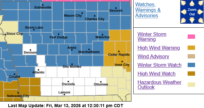
Monona-Harrison-Shelby-Pottawattamie Counties: WINTER STORM WATCH & HIGH WIND WATCH from 7-a.m. Sunday through 1-a.m. Monday.
* IMPACTS…Plan on slippery road conditions. Widespread blowing snow could significantly reduce visibility. The hazardous conditions could impact the Monday morning commute. Gusty winds
could bring down tree branches.
For the HIGH WIND WATCH: Northwest winds 30 to 40 mph with gusts up to 60 mph possible.
* IMPACTS…Damaging winds could blow down trees and power lines. Widespread power outages are possible. Travel could be difficult, especially for high profile vehicles.
PRECAUTIONARY/PREPAREDNESS ACTIONS…
Monitor the latest forecasts for updates on this situation.

