


Blizzard/Winter Storm Warnings/High Wind Warnings & Winter Advisory issued for Sunday, March 15th
March 14th, 2026 by Ric Hanson
1134 AM CDT Sat Mar 14 2026
…BLIZZARD CONDITIONS SUNDAY INTO MONDAY MORNING…
A significant winter storm will impact parts of the Upper Midwest this weekend, mainly from Sunday through Monday morning. Widespread snow will fall across Iowa with higher amounts of 6+ inches possible north and east. Winds will gust 55-65+ mph, resulting in significant drifting of snow and visibility reductions. Travel will become very dangerous, if not impossible at times across parts of northern and eastern Iowa. Precipitation will begin as rain on Sunday morning and
transition to a wintry mix, which may produce a light glaze of ice, before transitioning fully to snow.
Crawford-Carroll-Audubon-Guthrie-Dallas-Cass-Adair-Madison Counties:
…BLIZZARD WARNING IN EFFECT FROM 1 PM SUNDAY TO 7 AM CDT MONDAY…
* WHAT…Blizzard conditions expected. Total snow accumulations between 2 and 4 inches. Winds gusting as high as 55 to 65 mph.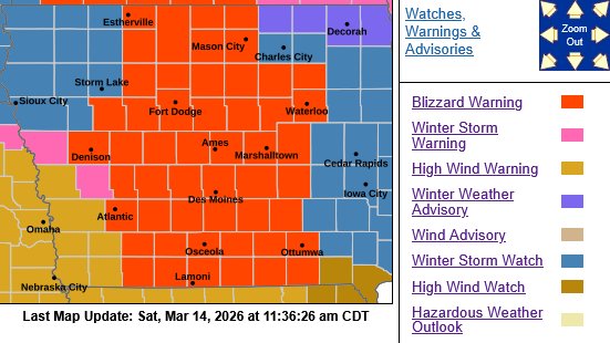
* IMPACTS…Plan on slippery road conditions. Widespread blowing snow could significantly reduce visibility. The hazardous
conditions could impact the Monday morning commute. Strong winds could cause tree damage and result in power outages.
PRECAUTIONARY/PREPAREDNESS ACTIONS…
Travel should be restricted to emergencies only. If you must travel, have a winter survival kit with you. If you get stranded, stay with your vehicle. For the latest travel conditions, check the Iowa 511 app, www.511ia.org, or dial 511.
Sac-Crawford-Carroll-Audubon-Guthrie-Dallas-Cass-Adair-Madison-Adams-Union-Taylor-Ringgold Counties….
…HIGH WIND WARNING IN EFFECT FROM 1 PM SUNDAY TO 4 AM CDT MONDAY…
Monona-Harrison-Shelby-Pottawattamie-Mills-Montgomery-Fremont-
Page Counties: HIGH WIND WARNING IN EFFECT FROM 7 AM SUNDAY TO 1 AM CDT MONDAY.
* WHAT…North winds 30 to 40 mph with gusts up to 55-65 mph possible.
* IMPACTS…Damaging winds will blow down trees and power lines. Power outages are possible. Travel will be difficult, especiallyfor high profile vehicles. With snowfall, white-out conditions are expected at times.
PRECAUTIONARY/PREPAREDNESS ACTIONS…
Remain in the lower levels of your home during the windstorm, and avoid windows. Watch for falling debris and tree limbs. Use caution if you must drive.
Monona-Shelby Counties….
…WINTER STORM WARNING IN EFFECT FROM 7 AM TO 9 PM CDT SUNDAY…
* WHAT…Strong winds with snow expected to cause periods of whiteout conditions. Visibility will drop below a quarter mile at times. Total snow accumulations up to three inches. Winds gusting 55 to 65 mph, a few gusts to 70 mph possible.
* IMPACTS…Blowing snow will significantly reduce visibility. Plan on slippery road conditions. Very strong winds may cause damage to trees and isolated to scattered power outages.
PRECAUTIONARY/PREPAREDNESS ACTIONS…
If you must travel, keep an extra flashlight, food, and water in your vehicle in case of an emergency. The latest road conditions for the state you are calling from can be obtained by calling 5 1 1.
Harrison-Pottawattamie-Mills-Montgomery-Page Counties…
…WINTER WEATHER ADVISORY IN EFFECT FROM 7 AM TO 9 PM CDT SUNDAY…
* WHAT…Very strong winds with periods of snow will lead to greatly reduced visibility. Occasional whiteout conditions possible with visibility below a quarter mile. Total snow accumulations up to two inches. Winds gusting 55 to 65 mph, a few gusts to 70 mph possible.
* IMPACTS…Blowing snow could significantly reduce visibility. Slippery roads possible. Very strong winds may cause damage to trees and isolated to scattered power outages.
PRECAUTIONARY/PREPAREDNESS ACTIONS…
Slow down and use caution while traveling. The latest road conditions for the state you are calling from can be obtained by
calling 5 1 1.

