


Blizzard & High Wind Warnings remain in effect today through Monday morning
March 15th, 2026 by Ric Hanson
…BLIZZARD CONDITIONS SUNDAY INTO MONDAY MORNING…
A significant winter storm will impact parts of the Upper Midwest today into Monday morning. Widespread snow will fall across Iowa with higher amounts of 6+ inches possible north and east. Winds will gust 55-65+ mph, resulting in significant drifting of snow and visibility reductions. Travel will become very dangerous, if not impossible at times across parts of northern and eastern Iowa. Precipitation will begin as rain this morning and transition to a wintry mix, which may produce light ice accumulations, before transitioning fully to snow.
Area Counties: Crawford-Carroll-Audubon-Guthrie-Dallas-Cass-Adair-Madison-Adams-Union-Taylor-Ringgold…A BLIZZARD WARNING REMAINS IN EFFECT FROM 1 PM THIS AFTERNOON TO 7 AM CDT MONDAY…
* WHAT…Blizzard conditions expected. Total snow accumulations between 2 and 5 inches. Winds gusting as high as 55-65 mph.
Sac County: BLIZZARD WARNING from 7-a.m. today until 7-a.m. Monday
* IMPACTS…Travel could be very difficult. Plan on slippery road conditions. Widespread blowing snow could significantly reduce visibility. Visibilities may drop below 1/4 mile due to falling and blowing snow. The hazardous conditions could impact the Monday morning commute. Very strong winds could cause tree damage and result in power outages.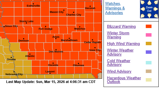
PRECAUTIONARY/PREPAREDNESS ACTIONS…
Travel should be restricted to emergencies only. If you must travel, have a winter survival kit with you. If you get stranded, stay with your vehicle. For the latest travel conditions, check the Iowa 511 app, www.511ia.org, or dial 511.
A WINTER WEATHER ADVISORY is in effect for Harrison-Pottawattamie-Mills-Montgomery-Page Counties from 7-AM Today until 9-p.m. and a COLD WEATHER ADVISORY is in effect on Monday from 1-a.m. until 10-a.m.
* WHAT…Very strong winds with periods of snow will lead to greatly reduced visibility. Occasional whiteout conditions are possible with visibility below a quarter mile. Total snow accumulations up to two inches. Winds gusting to 65 mph.
* IMPACTS…Blowing snow could significantly reduce visibility. bSlippery roads possible. Very strong winds may cause damage to trees and isolated to scattered power outages.
A HIGH WIND WARNING is in effect FOR: Crawford-Carroll-Audubon-Guthrie-Dallas-Cass-Adair-Madison-Adams-Union-Taylor-Ringgold Counties FROM 1-P.M. TODAY UNTIL 7-A.M. MONDAY, and from 7-a.m. today until 1-a.m. Monday for Monona-Harrison-Shelby-Pottawattamie-Monona-Mills-Montgomery-Fremont and Page Counties.

